Focus on Ferries to East
Bay/Delta Region
An Integral Part of the
Solution
BY TOM STEWART AND MARINA
GOTTSCHALK

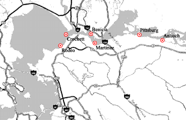
Colorful and historic cities along the eastern portion of San
Pablo Bay and extending into the Delta have been identified as possible sites to
access a water-oriented transportation system that will serve the entire Bay
Area if completed. With the work of the Water Transit Initiative Task Force
(Task Force) at an end and the establishment of the San Francisco Bay Area Water
Transit Authority (Authority) to evaluate planning and engineering feasibility
and funding, Contra Costa and Solano counties are poised to participate in the
expansion of high-speed ferry service offering a viable alternative to
congestion-choked residents of the area.
Yet significant questions remain for the counties and the
region generally. The study, Vision and Conceptual Design for a Bay Area
High-Speed Water Transit System, completed by the Task Force in February
1999, envisioned an initial, critical mass phasing that would include both the
cities with already established ferry service (Richmond and Vallejo), as well as
cities planned for
With the number of existing and potential water transit
routes and terminal locations in Contra Costa and Solano counties along the
eastern and northern portions of San Pablo Bay and into the Delta, moving
forward with water-oriented transportation solutions is of critical importance
to residents of both counties. At the same time, these counties face unique
challenges and potentials given the demographics, topographies and economies
that define their unique character and charm. As an accompaniment to this
article, profiles of a number of these communities are incorporated in an
attempt to define what this energetic and distinctive region has to offer its
residents or visitors to the area.
With the exception of Vallejo and Richmond, large cities with
established ferry routes to San Francisco, the remaining cities vary in size,
infrastructure and proximity to other transportation alternatives (mass transit,
highway and rail). Common to all, however, is their identification in the Vision
and Conceptual Design report by the Task Force as potential sites for water
transit terminal locations.
Why were these locations selected? A part of the answer lies
in their historical context prior to the construction of the major bridges and
highways, in many cases dating back to the days of the Gold Rush and, later on,
for the transport of people, goods and services, and agricultural products.
Benicia, Crockett, Rodeo and Martinez served as ferry terminals before the
construction of the Benicia-Martinez and Carquinez bridges, I-80 and I-680. With
the construction of the bridges and highways, the ferry terminals and routes
were abandoned, but ultimately, as the population of the Bay Area expanded, the
need to reevaluate these former transportation routes as the once high-speed
super-highways slowed to gridlock during commuting periods. This condition is
only expected to worsen as the population continues to grow and expand outward
beyond the Bay Area.
Developing a critical mass sufficient to support ferry
service is an ongoing issue of concern. One of the proposals presented to the
Task Force during its public hearing process and unique to this region is a
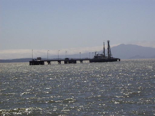
proposal from the Coastal Corporation, owner of the former Pacific Refining
Company wharf located off the Rodeo shoreline.
In conjunction with decommissioning its refinery that closed
in 1995, Coastal looked at opportunities to utilize its wharf, formerly used to
load and unload petroleum products, for an alternative public purpose instead of
demolishing the structure. Ralph Edwards, Coastalís director of environmental
services and regulatory affairs, sees the wharf as a possible solution to
address the issues of ridership, cost, and timing along the eastern portion of
San Pablo Bay and into the Delta, as well as expediting the feasibility of
providing ferry service to that area.
The wharf, a 7,200-square-foot (60í x 120í),
free-standing structure along the shipping channel in San Pablo Bay,
approximately one mile from the shore, was constructed in the 1960ís on
property leased from the State Lands Commission. When faced with demolition or
preservation, Edwards opted for alternatives that would use the wharf for some
form of public benefit, recognizing that once demolished, a structure of that
magnitude would never again be constructed on San Pablo Bay given current
environmental regulations.
Coastalís concept for the wharf is as a potential transfer
point between smaller vessels providing service to communities located along San
Pablo Bay and up into the Delta, to high speed vessels serving major
destinations within the Bay Area. The wharf would function as a point of arrival
and departure, with passengers collected from vessels serving smaller
communities that might not be economically feasible for construction of a
terminal and a larger vessel. Once off-loaded at the wharf, the passengers would
board high-speed ferries to major ports that would increase as new routes are
established and existing routes expanded. Considering the size and capacity of
the wharf, beyond constructing a shelter for riders awaiting ferries, it could
also accommodate a restaurant or other public amenities.
"Itís a question of the cost to demolish the structure
versus preserving it for public use," Edwards said. "After talking
with a number of public agencies and looking around for about a year, we heard
about the work of the Task Force and felt there was a connection."
Edwards outlined the various benefits the wharf could
potentially provide, these include:
"Now that the Authority has been formed, we are hopeful
that they will seriously consider what may well be the best solution to the
challenges of providing ferry service to this region," he said.
To understand how this region fits into the proposed water
transportation system and some of the unique features of this area, an interview
was conducted with an expert on the subject who has been involved with the
proposal for expanded ferry service since its inception and has a history in the
area of water transportation.
Michael Fajans is a project manager with Pacific Transit
Management Corporation (PTM), his water transit-related experience includes
serving as a consultant on a number of projects, among them development and
subsequent update of the Regional Ferry Plan for the Metropolitan Transit
Commission (1991-92 and 1999), the City of Vallejo Specific Plan (1991-92), the
cities of Benicia and Martinez, and as a subcontractor to Dames & Moore on
the Vision and Conceptual Design for the Task Force (1999). In speaking with Mr.
Fajans, he was asked the following questions:
How do the studies that will be done by the Authority differ
from what was done by the Task Force?
The initial study performed for the Task Force was
preliminary in nature and did not go into the level of detail that will be done
by the Authority. The charge of the Authority, beyond its establishment,
appointing a Board of Directors and hiring staff, is to begin the planning and
engineering studies mandated by the legislature that are required to establish a
water transit system to serve the Bay Area. The Authority needs to look at
anything remotely feasible; and any alternatives that have not already been
considered should be submitted to the Authority for evaluation.
Based on your experience, do you see ferry service expanding
in the Bay Area as envisioned by the Task Force?
Yes. Over the next 10 to 20 years, vessel technology will
continue to improve, ferries will get faster and roads will get slower. Itís
just a matter of time before the decision is obvious. My hope is that it will be
sooner rather than waiting for conditions to deteriorate.
Is ferry service cost competitive as compared to other
alternatives?
Absolutely. The quality of life in the Bay Area will
be threatened if we do not find transportation alternatives that allow
reasonable transit times as compared to sitting in traffic. The assumption that
people will abandon other forms of mass transit does not make sense if we look
at the ridership on existing ferry service routes. Most of those people got out
of cars to ride the ferries. At the same time, we need to make sure that we do
not supplant an existing mass transit alternative, but rather strive to
interconnect all the existing systems so that they are as seamless as possible.
An interesting sidelight is the anticipated patronage for the Vallejo ferry.
Initially, it was thought that visitors to Marine World would make up the bulk
of the ridership. Once people discovered there was an alternative to driving to
San Francisco, they opted to ride the ferry instead, despite the fact that this
was during the era of run times averaging 75 minutes.
In providing ferry service, what are some of the unique
challenges facing this region?
One of the issues is providing service to smaller communities
that may not have the population base (or demand) to support the cost associated
with constructing a terminal and purchasing a high-speed vessel. For that
reason, any alternative that would provide a passenger base, such as a transfer
point for passengers or smaller collecting vessels, provided it does not
substantially increase transit time, should be considered.
What do you think of the former Pacific Refining
Company wharf as a collecting and transfer point for vessels serving terminals
along the western portion of Contra Costa County and into the Delta?
Itís worth a look at the concept. The issue to consider is
whether the wharf proposal could help to address the issue of passenger count
that is needed to support the cost of providing high-speed ferry service. As I
discussed earlier, one of the fundamental considerations is having a sufficient
number of riders to justify service. Again, any alternative that could assist in
achieving the critical mass needed to establish and maintain service should be
investigated.
The major decisions regarding water transit in the Bay Area
have yet to be made. While the Authority has been formed, a full compliment of
Board members have not been appointed and staff hired, and the issue of funding,
a major hurdle, has yet to be faced. At the same time, the Authority is charged
by the legislature with the responsibility for engineering and planning and the
future has never looked brighter for the return of ferries to the Bay in numbers
and frequencies matching or exceeding historical levels.
In its deliberations, the Authority will need to look, as
Michael Fajans suggested, at "any alternative that could assist in
achieving the critical mass needed to establish and maintain serviceÖ"
Water transportation and unique proposals, such as the wharf put forth by
Coastal Corporation, deserve to be evaluated as potential solutions to
transportation issues facing the Bay Area.