The
large, intriguing building in Point Richmond adjacent The Tunnel is
the Richmond Municipal Natatorium, or the Plunge, Richmond’s
indoor swimming pool built in 1911 as an exploratory oil well.
Instead of oil, they found water, a pool was built, and has remained
open since 1924. Next to the plunge is The Tunnel, which opened in
1915 to allow for passage through Nicholl Knob. The Tunnel is graced
by one of John Wehrle’s murals. John Wehrle is a Richmond muralist
who adds a sense of whim to the Richmond street scene at other sites
as well, like the 150’ mural at the Macdonald Avenue I-80
underpass off San Pablo, which depicts a mirror image of the street
with a ghost trolley and passengers from 1908 materializing across
from the freeway onramp. He has done another one at Barrett and San
Pablo Avenue, depicting Ohlone and early Californios interacting
with current residents on a street scene of storefronts with
historical references. Beyond the mural, The Tunnel leads to Miller
Knox Regional Park, Ferry Point, the Red Oak Victory (which
is slated to move closer to the Rosie the Riveter Memorial), and
eventually ends at the Brickyard Marina.
Miller Knox Regional
Shoreline houses the Golden State Model Railroad Museum where you
can watch 5 working model trains in action and. You can hike the to
the
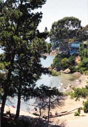 |
| Keller
Beach |
top of Nicholl Knob in the
hills for fabulous views of the bay. Keller Beach provides shoreline
access, with a sandy beach. At the southern end, Ferry Point, also
an East Bay Regional Park, has a nice walk out to the original pump
house building and pier from the old Santa Fe Terminal. This was the
western terminus of the Atchinson, Topeka and Santa Fe railroad,
which from 1900, ran ferries, tugs, and barges to San Francisco and
China Basin. Santa Fe continued barging freight cars to China Basin
well into the 1980s. For a short time in the late 1920’s, the
Southern Pacific’s Golden Gate Ferry Terminal was located nearby,
just west of Richmond Terminal #1, at the foot of Dorman Drive.
Richmond Terminal #1 is visible to the south from the shoreline, and
from Ferry Point you can see the bough of the Red Oak Victory,
which is being lovingly restored here. The ship is open for tours
weekends through the Richmond Museum. Some of the volunteers working
to restore the Red Oak Victory are women who helped build the
ships.
You can continue around the
corner into the Brickyard Cove, home of the Brickyard Cove Marina
and the Richmond Yacht Club. It has been built around the kilns and
smokestack of the Richmond Pressed Brick Company, the last to close
down of Richmond’s local brickyards. Richmond Pressed Brick
Company was around at the turn of the century, and supplied brick
for the rebuilding of San Francisco after the 1906 earthquake. The
brick kilns and smokestack have been preserved by the developers for
character. All’s Fair restaurant in the Brickyard Marina offers
tasty waterfront meals.
From Point Richmond, you can
take surface streets to Western Drive. From the base of the
Richmond-San Rafael Bridge, this 4-mile, paved road leads past some
of the area’s more colorful history-an old Chinese shrimp village,
a whaling station, and a castle that housed Richmond’s first and
only winery, before heading through the Point Molate US Naval Fuel
Depot, and out to the San Pablo Yacht Harbor. From here the boat
departs to take you to historic East Brother Light Station. Western
Drive also delivers great views of the Bay and the Richmond-San
Rafael Bridge. The bridge was completed in 1956, built in part as a
result of a series of ferry strikes that badly maimed regional
transportation. In addition to carrying traffic, the bridge now
houses a colony of nesting cormorants. With up to 300 nests in this
group, biologists have scaled the bridge and learn more about
cormorant behavior. They contemplate that the cormorants are here,
in part, to feed on the humming toadfish that migrate in the bay in
the summer months, providing a food source for the cormorants, who,
at that time of year, are feeding their young.
Along Western Drive, you
will pass Castro Point, site of the Richmond-San Rafael Ferry
Terminal from 1915 until Richmond-San Rafael Bridge was opened.
Nearby Point Molate Beach Park, is the site of a Chinese Fishing
Village that bustled here from the 1860s to 1912. In its heyday, the
village consisted of about 30 shacks and several wharves, where
shrimp were harvested and either sold locally, and dried and sent to
China. Traces of the village have since been reclaimed by the bay.
Off shore is Red Rock, also known as Golden Rock in the past, in
reference to the legend of treasure hidden here in the days when
pirates patrolled the bay. This was also the site of the Red Rock
Fishing Resort in days gone by. Back on Western Drive, you soon
enter the Naval Depot. A sign directs you to stop at the Visitor
Center if you plan to do anything but pass through to the Yacht
Harbor. They have historic photographs of the area worth checking
out. Nearby is Winehaven. ("Our castle," boasts Mary,
lifetime Point Richmond resident and docent at the Richmond History
Association museum.) This fabulous brick building indeed maintains
the architectural lines of a castle. From 1906 to 1919, Winehaven
was one of the world’s largest wineries. Conveniently located near
shipping lanes and rail service, grapes were brought here from all
over California, and wine made here was shipped all over the world.
Winehaven produced over 60 wines, as well as brandy and champagne.
In its heyday, it’s ships carried barrels of wine across the bay
daily to San Francisco. Prohibition officially halted operations in
1919. The buildings are national historic landmarks, and were used
by the Navy fuel depot from 1941 to demilitarization in 1995.
Western Drive continues
along the shoreline to Point Orient, where the East Brother Light
Station comes into view, then climbs up and over a hill to the San
Pablo Yacht Harbor. Overlooking the San Pablo Bay, and isolated from
the rest of the world by hills covered with sticky monkey flower and
coyote bush, the harbor is delightfully worlds away from modern
times. The harbor changed hands recently, which has triggered a
remodel of The Galley restaurant here. It will be re-opening soon
for harborside meals. This harbor is near the site of a former
whaling station, but, the station buildings (to the west of the
harbor) have since burned to the waterline. Now stumps in the water
there are all that’s left of Point San Pablo’s whaling days. The
whaling station here at Point San Pablo was in business from 1956
until 1971, and whales caught in the Pacific were brought here for
processing. San Francisco was, by the late 1800s, the world’s
largest whaling port, but the whaling industry collapsed when
petroleum replaced whale oil, and steel replaced whale bone. Whaling
everywhere ended when the fishery was closed down by the federal
government’s ban on commercial whaling in 1971. There was also a
small sardine port and processing point near the tip of Point San
Pablo during the 1940s which thrived until that fishery collapsed.
You can still try your hand at fishing with one of the sportfishing
outfits out of Point San Pablo Yacht Harbor.
If you are continuing on to
the East Brother Light Station, you can see the remains of the
whaling station from the boat, the last whaling station on the west
coast. The boat delivers you to a 5-foot ladder which you must
negotiate from the bobbing boat to the island. Upon your successful
completion of the journey, you will be pampered at the inn by the
exquisite accommodations and gourmet food offered at the 1878
lighthouse. Or, if you’ve just come for the day, you can bring a
picnic, have a lighthouse tour, and relax for the afternoon. The
lighthouse was manned by Lighthouse Services personnel until it was
automated in 1969. It was decommissioned and restored by local
preservationists in 1980.
If you’d like to see more
of San Pablo Bay, you can take AC Transit, or the bike surface
streets to Point Pinole Regional Shoreline, which is, with over
2,000 acres, one of the bigger East Bay Regional Parks. Here you can
hike 11 miles of trails, watch for colonies of monarch butterflies
who migrate here to flock the eucalyptus trees, or take the shuttle
to the pier which juts over 1,200 feet out into San Pablo Bay. From
the pier, you can appreciate this large open shoreline, a breath of
fresh air in the lair of the East Bay’s oil refineries. Like most
of the bayshore, this little peninsula has an interesting past. The
Giant Powder Company moved here in 1892 and set up the company town
of Giant, along with its plant to produce explosives used throughout
the world in major earth moving efforts. Since 1960, when the
company left, the company town became part of a residential
development, and mother nature has taken over the rest. All that
remains are some in-cognito, blast-protecting concrete bunkers.
Though I hope Point Pinole,
the shoreline along Western Drive, and the enclave of Point Richmond
don’t change much at all, because they are charming the way they
are, Richmond’s southern waterfront is very much emerging. As the
Rosie the Riveter National Historical Park takes shape alongside the
ever developing Bay Trail, coupled with the restoration of ferry
service, the Richmond waterfront will draw increasing attention to
the natural and cultural attributes of this hard working town. And
well deserved attention it will be. Richmond’s waterfront setting
is beautiful, and Richmond’s role in the wartime shipyards is a
fascinating story worthy of the national interest it has begun to
receive. Enjoy your visit to Richmond.
