Summertime, and the bikin’ is easy, thanks to new Bay Trail maps that give bicyclists, as well as walkers, skaters and wildlife watchers, a fresh look at sites and adventures along San Francisco and San Pablo Bays. A total of 40 miles have been added since the last Bay Trail maps were published in 2003. With easy access by ferry to many Bay Trail points, hiking and biking the Bay Trail is the perfect summer experience.
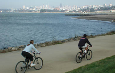
Photo by Jay Jones
By Marjorie Blackwell
Published: July, 2007
A total 290 miles of Bay Trail have been completed — more than half the 500 mile total route that eventually will link the shoreline of all nine Bay Area counties and 47 cities that touch the Bays.
Here are some favorite Bay Trail hiking and biking trips you can combine with ferry rides.
San Francisco to Marin County Ferry Loop: This bike ride begins at Pier 41, travels through Fisherman’s Wharf, Marina Green and Crissy Field, crosses the Golden Gate Bridge and heads down to Sausalito. From there you can catch a ferry back to San Francisco, or you can continue on another 13 miles to Tiburon, passing by the Richardson Bay Audubon Center, and board the ferry back to San Francisco in downtown Tiburon.
Angel Island: Ride a ferry from Oakland, San Francisco or Tiburon to this island park in the middle of the San Francisco Bay for a hike or bike ride on the wide, paved Perimeter Road that loops around the top of the island. Enjoy lunch in the grassy picnic area before your ferry ride home.
Heron’s Head Park: From the San Francisco Ferry Building, bicycle south along the Embarcadero; connect to Terry Francois Boulevard and Illinois Street, then turn left on Cargo Way in Hunters Point. Follow the gravel pathway to the edge of an emerging shorebird habitat that gives firsthand views of wetland restoration in progress. Interpretive signs tell the story of native flora and fauna that have reclaimed the area. You can continue south across the bicycle/pedestrian bridge and follow the shoreline path as it wraps around the edge of the PG&E Hunters Point Power Plant, now closed. The trail leads to a cove at India Basin Shoreline Park.
Vallejo Waterfront Trail: From the Vallejo Ferry terminal, head north on foot or bicycle along the waterfront promenade. The paved trail stretches for 1.5 miles along the shoreline, passing marinas, the Vallejo Yacht Club and River Park marshes.
New Bay Trail segments completed in the past two years offer several hiking and biking routes that easily can be combined with ferry rides:
West Oakland: Bike lanes now run from Jack London Square through West Oakland to Emeryville, connecting with the Bay Trail that stretches along the Bay shoreline through Eastshore State Park all the way to Richmond, an ambitious round-trip ride of 28 miles.
Middle Harbor Shoreline Park: From the Oakland ferry terminal, head north on 7th Street to Middle Harbor Road. Pass through the intersection and take first right into the park’s parking lot. From there you can walk or bike through this new 37-acre shoreline park that offers stunning views of the Bay Bridge and San Francisco as well as close-up views of the massive cranes and ships at work in the Port of Oakland.
New Bay Trail Maps
The new set of six colorful Bay Trail maps features 290 miles of completed trail and showcases attractions in all nine Bay Area counties. The back sides of the maps feature 40 recommended routes to inspire and guide shoreline recreation. Details for each route include directions, distance, trail surface, natural and historic points of interest, and parking and transit information. The six-map set is priced at $15, and individual maps are $3.50 plus tax and shipping. To order, visit www.baytrail.org or call the Association of Bay Area Governments at (510) 464-7900. The Bay Trail maps also are sold at the Bay Crossings store in the San Francisco Ferry Building.
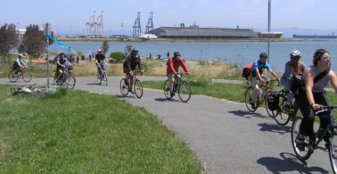
Photo by Laura Thompson
