I knew it was not going to be a cruise with deck chairs and little umbrellas in my drinks. But in early July, I had the chance to fulfill a childhood dream with a voyage on a "bulk carrier" freighter. The CSL Acadian was chartered from British Columbia to the Bay Area to carry 70,000 tons of sand and gravel for use as concrete in the new east section of the Bay Bridge.
By Tom Paiva
Published: August, 2007
Upon my arrival in Vancouver, I learned that change is the only constant when it comes to freighter schedules. The ship had been set to sail from a bulk terminal at the Port of Vancouver, an easy taxi ride from downtown. On the day before, however, it was repositioned to sail from Port McNeill, a town hundreds of miles away on the remote northern tip of Vancouver Island. After a ferry ride and a long rental-car trip, the ship was delayed for another day and I spent the night at a fishing lodge in Quatsino, British Columbia. Otters, bears and eagles seemed more at home there than people.
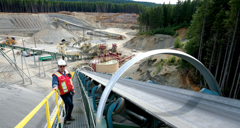
The delays actually proved helpful because I was able to tour the ultra-modern quarry operation where our load originated. Before my trip, I wondered why 70,000 tons of sand and gravel would travel 1,200 miles when we have so much sand in California. However, during my tour I learned that this particular sand is highly desirable for structural concrete in major projects worldwide. It is especially strong and yet flexible when made into concrete�qualities that will help the new Bay Bridge withstand tremors. This sand sells for about $38 per ton; local California sand is $20 per ton.
The next day, we were scheduled to sail in the early evening. Sharla, the ship�s agent�she adeptly handles all of the local logistics�called around 8 a.m. and said the ship�s departure had been moved up to 11 a.m. I had to scramble to check out of the fishing lodge, get rid of the rental car, and hitch a ride with Sharla for the final 20 miles from Quatsino to Port McNeill.
By early afternoon, two tugs came alongside the Acadian as the pilot arrived to guide the ship through the Queen Charlotte Straits. As required by law, Captain Symonov passed control of his vessel to a Canadian pilot who steered the ship through the unique waters of that area. The sky was densely overcast, as it usually is in this part of the world, making the sea equally dark and gray. The cold 20-knot headwind wind combined with our 12-knot speed to amplify the 45-degree damp chill. The monochrome colors were a fitting start for our sea voyage.
The Acadian flies Bahamian flags, a financial decision that allows the Canadian shipping line to use a non-Canadian crew. This particular crew of 28 were all Ukrainians save for one Canadian cadet. Russian was the language spoken on board unless I was involved in the conversation. The crew�s English was good�especially the officers��and they answered all of the dozens of questions I asked. The food also had a Ukrainian touch, with borscht or fish soup available at every meal. We had a nice surprise when the Canadian pilot came aboard with several fish they had caught off the pilot boat while waiting for the freighter to arrive. It was a welcome gift and we ate fresh fish for a couple of days.
Freighters take the fastest sea route and do not hug the coastline; we typically sailed more than 100 miles out at sea. On the first day, the open Pacific Ocean hit us with 20-foot swells and gale force winds of 40 mph, but the unfazed bridge crew said 30-foot swells and 50-plus mph winds are commonplace. We were lucky that the winds were at our stern, from the northwest, which kept the rolling and pitching down to around 6 degrees. As a landlubber, I could barely walk without holding on and was grateful for the pressure-point wristband that deferred my inevitable seasickness.
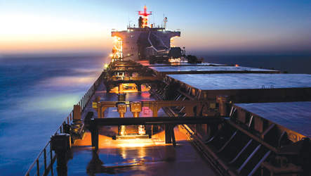
By the third day, the seas were a lot calmer, the sky bright blue, and the weather in the mid-70s. While leaning on the guardrail, I felt as though I actually was on a cruise! Because the ship was nearly fully loaded, it was only about 20 feet from the lower deck to the water, giving me a more intimate view of the sea than is typical of a cruise ship. Sea spray would frequently splash onto the deck as we sailed along at 15 knots. Twilight, which was at 10 p.m. this time of year, was an especially amazing time to be on deck. There were no vessels within 70 miles, and as the ship slowly rolled, I felt at one with the sea.
On the fourth and last day at sea, I awoke to dense fog and the regular blast of the foghorn as we were sailing down the northern California coast. I could not even see the bow from the bridge. The officer on duty watched the radar carefully and listened for other ships� foghorns.
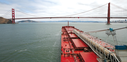
By midday, the fog lifted and I saw land for the first time in three days. It was Point Arena, and an hour later we were at Point Reyes; I knew that my adventure was soon coming to an end. A pod of whales came alongside the ship as we approached the pilot station, which is some 12 miles from the Golden Gate. At this point, a San Francisco-based pilot came aboard to guide us safely through the Golden Gate to our anchorage in the Bay. Coming in by ship under the Golden Gate, past Alcatraz, beside the unique City skyline, and finally under the Bay Bridge was a rare way to see the place I call home.
In the end, the voyage was something few get to experience. Whenever I drive the new Bay Bridge in the future, I will always recall the extraordinary adventure I had accompanying the sand and gravel that make the bridge a strong and enduring symbol of our magnificent region.
Tom Paiva is a professional photographer with his own business shooting architecture and maritime related photography for over 15 years. He earned a BFA from the San Francisco Academy of Art. Visit his website at www.tompaiva.com.
Tom Paiva Photography
310-559-9545
310-430-0552 cell
All images copyright Tom Paiva Photography