Beyond industrial Oakland and suburban Walnut Creek lie areas of the East Bay popping with adventures. With spring temperatures and fresh colors in the hills, now’s the time to go.
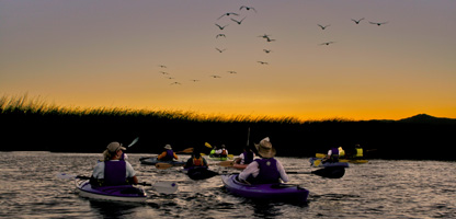
Peilcan Crossing, Suisun. Photo by Derrick Davidson
By weekendsherpa.com
Published: May, 2008
Suisun Sundowner
Monterey and Point Reyes might get all of the kayaking fanfare, but the Suisun Estuary near Fairfield holds its own with them. In fact, it’s the biggest wildlife estuary in the lower 48 and remains largely untapped by the kayak and canoe crowd. The estuary was once a major transportation canal used by the Patwin Indian tribe, and its magic was not lost on Trish Abbatiello of Sunset Bay Kayaks. For the past nine years, she has rented kayaks to some of the lucky folks who have discovered this watery oasis. Her new shop is in the heart of old Suisun City, right across the street from the put-in. Go on a naturalist-led tour or take to the water on your own. We recommend the self-guided 1.5-hour Sunset Kayak. As the sun sinks on the horizon, you’ll paddle south past houseboats and the marina, heading toward pyramid-shaped Mount Diablo. Take the first right into Peytonia Slough and follow it west toward the setting sun. Keep an eye out for beavers, ducks, and pelicans. When you’re ready, paddle out of the slough and back to the dock, where Trish will be waiting to help you unload. It’s modern-day service amid an ancient Northern California secret.
TIP: After changing out of wet shorts and shoes, grab a bite down the street at Main Street Bar and Grill. The downstairs has white tablecloths and candles, while the upstairs is more casual, with a long bar and TVs. The menu ranges from New York steaks to salmon fillets.
Bring a windbreaker or fleece and a change of clothes, including socks and shoes.
Sunset Bay Kayaks, 607 Main St., Suisun City; 707-429-5925. $15 per person for the Sunset Kayak. $30 per person for a Naturalist Tour.
Main Street Bar and Grill, 627 Main St., Suisun City; 707-428-6270.
Ring around the Mountain
It offers one of the biggest views in the West: an eye-candy panorama that includes more than 200 miles of California landscape. Which is why the Grand Loop on Mount Diablo should be on your to-do list this spring. This 6.5-mile trek around the East Bay’s tallest peak is grand in more than just its beauty: it’s a real thigh burner with substantial uphill stretches, so be sure to bring lots of water—and energy. Starting from the Juniper Campground parking area at 3,000 feet, the loop leads clockwise around the mountain, then climbs right up to the summit. From the path, a rich green landscape unfolds across the coastal range and down to the bay. Along the way, lupine, poppies, and lilies add color. The final leg of the ascent (the Prospectors Gap and North Peak trails) is especially steep. But keep at it; the scenery from the top is—need we repeat?—absolutely grand.
This exposed trail gets firecracker hot in summer, so we recommend hiking it before then. And the trail gets steep, so wear shoes with good tread. Directions: Park at Juniper Campground off of Summit Rd. There are two paved roads; walk down the one on the right to Deer Flat Rd. Continue on Deer Flat Rd. for 1.5 miles until you reach Deer Flat. Go right on Meridian Ridge Rd. Continue on this for about a mile through Murchio Gap and up to Prospectors Gap Trail (an Eagle Peak side-trip can be made at Murchio Gap). Continue up the Prospectors Gap Trail for 1.3 miles until you reach Prospectors Gap (a North Peak side-trip can made here). Go right, up the North Peak Trail toward Mount Diablo’s summit. Reach Devil’s Elbow after 1 mile and go right, up the Summit Trail to the lower summit parking lot. Walk to the back of the lot and descend the Juniper Trail 1 mile back to your car.
Foothill Ramble
Thanks to active groups like Save Mount Diablo, much of the area surrounding this East Bay icon has been preserved from development, leaving a playground of expansive hiking and mountain biking trails. Hop on your mountain bike to explore the western side of the mountain through the rolling hills of the Shell Ridge Open Space, just outside of Walnut Creek. This 11-mile loop, for intermediate and advanced riders, links three unique sections of open space, and has 10—yes, 10—creek crossings, so expect wet toes. A good map is essential (see below). (Beginners and those averse to wheeling through the creeks can opt for a shorter out-and-back route.) The first few miles along the Briones-to-Mount Diablo Trail ramble along wide fire roads with a few climbs and descents and gate pass-throughs; this part of the ride features plenty of surrounding greenery, grazing cows, and pockets of poppies in the hills. Big oak trees provide rare shade on this mostly exposed stretch, which passes through Diablo Foothills Regional Park before entering Mount Diablo State Park. To pedal the full 11-mile route, energetic riders can link together Wall Point Rd, Dusty Rd., and Stage Rd.—get ready for those ten creek crossings. Refreshing!
Because of exposed trail sections, this ride is best done early in the day or when cooler temperatures are in the forecast. Save Mount Diablo has an excellent map
29-year-old WeekendSherpa.com founder and managing editor
