Clipper Cove, a place name that appears on no chart, is one of the most popular anchorages in all of San Francisco Bay. It is bounded by Treasure Island on the north and Yerba Buena Island on the south.
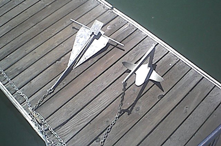
Danforth anchor on the left and a Bruce anchor on the right.
By Captain Ray
Published: August, 2008
There is a narrow causeway on the west side of the cove connecting the two islands and providing road access to Treasure Island from the Bay Bridge. Yerba Buena Island is a natural island, but Treasure Island was build by the City of San Francisco to be the site of the 1939 Golden Gate International Exposition. Afterward it was used as an airport for the PanAm Clippers, the flying boats that crossed the Pacific before jet passenger travel. The cove was created to be a taxiway for the aircraft and this is the origin of its name. San Francisco later traded the island to the U.S. Navy; it served as a Navy base until the 1990s when the Navy closed the base and the island was returned to City control.
Boats enter the cove from the east, and while there will encounter protected flat water for anchoring when the wind is from any direction other than east. I’ve never seen it completely empty, and I have seen as many as 60 to 70 boats anchored there on summer weekends. The bottom is mud and offers good holding for Danforth type anchors most of the year. Occasionally, in late summer and early autumn, I have had difficulty getting a Danforth to hold. When this happens, I switch to a Bruce and have had great success. I suspect that there is a bloom of grasses on the bottom at that season, and the Danforth—unlike the Bruce—isn’t heavy enough to cut through it to the mud below.
At first glance, access to the cove certainly looks straightforward. The entrance appears to be over one quarter of a mile wide. The chart, however, tells a very different tale. That seemingly wide open entrance is constricted by a bar with some quite shallow spots. The bar extends almost three-quarters of the way across the opening, from the point on the south side—where the new Bay Bridge tower is being constructed—toward the end of the pier on the north side. The chart shows a minimum depth of three feet.
Over the years, I’ve seen 10 or 12 boats aground on this bar. Sometimes, of course, the tide will be high enough so that there are no issues, but at other times it will be low enough so there are. The safest way into Clipper Cove is to stay close to the pier. The white and blue buoy that you see on the way in is an abandoned mooring and not an aid to navigation, but passing between it and the pier will help keep you in deeper water. Once you’re halfway down the pier you can come to port and shape your course to clear the corner of the island and the dinghy dock.
It seems that shoaling has gotten worse in the past few years. There will be times when boats drawing 5 ˝ feet or more may not be able to get into Clipper Cove—or get out, should you be in! So when entering Clipper Cove, proceed slowly, monitor your depth sounder (if your vessel is equipped with one), and have another destination in mind just in case.
Ray Wichmann,
is a US SAILING-certified Ocean Passagemaking Instructor, a US SAILING Instructor Trainer, and a member of US SAILING’s National Faculty. He holds a 100-Ton Master’s License, was a charter skipper in Hawai’i for 15 years, and has sailed on both coasts of the United States, in Mexico, the Caribbean, and Greece. He is presently employed as the Master Instructor at OCSC Sailing in the Berkeley Marina.