Like treasure hunts? Then head for the hills near Auburn and have an adventure that could be straight from a sequel to The Goonies.
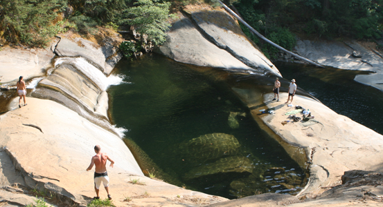
University Falls near Auburn is a series of natural rock waterslides, separated by giant pools of cool mountain water. Photo courtesy of WeekendSherpa.com/Brad Day
By weekendsherpa.com
Published: August, 2008
The Goonies II
A 2.5-mile, unmarked hike (or bike and hike) with twists, turns, and the eerie remains of a truck wreck takes treasure-seekers to watery riches: a series of three natural rock waterslides, separated by giant pools of cool mountain water. Known as University Falls, this whoop-and-holler triple wonder would thrill even the likes of Mikey, Mouth, Data, and Chunk. Muster the courage to speed down the first slide. Then catch your breath and hit the next two while you listen for your own squeal. (There is a fourth slide, but it’s dicey and not recommended.) Hidden trails. Old car wrecks. Natural waterslides. And you… Join the adventure.
Arrive early (before 10 a.m.) or late (after 3 p.m.) to avoid the boom box-and-cooler crowd. As with all swimming holes, swim at your own risk; there are no lifeguards at University Falls and there have been accidents. University Falls is 30 miles (50 minutes) from Auburn. Head to Auburn on I-80, then take Hwy 49 south to the town of Cool. Go east on Hwy 193 to Georgetown. Go left onto Main St. (at the Napa store); this is Wentworth Springs Rd. Take this about 12 miles. Just after passing through the town of Quintette, find parking on the left. From here, allow 90 minutes to walk in. Walk past the bright yellow gate; 200 feet past the gate, continue straight on the fire road. Go left at the next fork (sign 12N67B). Go right at the bend (look for blue arrows on the rocks). Follow this trail down and make a hairpin right onto the trail that follows the Pilot Creek water canal; continue about .5 mile. Look for the obvious side trail that descends to the left and take it. After 100 feet, go right at the first fork (look for blue paint on the tree). This descends to the falls. Dog-friendly!
Take Me Down to Lazy River
Being lazy ain’t so bad, especially if it’s along the banks of the San Lorenzo River, near Felton in the Santa Cruz Mountains. Here, swimming holes are as abundant as the redwoods, so take your pick. A simple hike gets you to all of them. Most people head to Garden of Eden (via the 0.7-mile Ox Trail, just south of Henry Cowell Redwoods State Park). This is a great spot, with lots of giant rocks and two deep swimming holes. But be prepared: it can turn into a waterfront version of High School Musical 3. For a more secluded and quiet section of the river, take the first spur trail off of Ox Trail, after crossing the railroad tracks. As you descend, a summertime oasis slowly reveals itself: a wide sandy beach, offering sun, shade, and relative solitude (pictured). The gently flowing river is also a great place for pool toys (inner tubes or inflatable recliners are ideal). Bring a book, some munchies, and a beach blanket. Lazy days are here again.
The parking pullout is on east side of Hwy 9, 1.2 miles south of the Henry Cowell Redwoods State Park entrance. Look for the Ox Parking Lot sign and walk down the Ox Trail. To reach the Garden of Eden, cross the railroad tracks, continue .25 mile and look for the signed spur trail on the left. To find the other, more secluded beach, cross the railroad tracks, go 50 feet and take a spur trail to the left. Look for a brown State Property sign on a 20-foot tall tree stump; this sign is by the correct spur trail. No dogs.
Basstastic!
Behold the Northern California coast: rugged, inspirational, and freakin’ freezing. Where can you enjoy a shoreside swim without risking hypothermia? Try Bass Lake in Point Reyes National Seashore. It’s a scenic 2.7-mile coastal hike up from the parking lot, and the water’s warm (warmer than the Pacific, at least) and clean. The up-again, down-again rope swing was up-again when we last visited in early July. Be careful getting to it—poison oak encroaches the trail. A plunge into the Bass won’t freeze your ass—but watch the posterior-poking nettles when you’re changing in the bushes. We’re also assuming you don’t mind the occasional free-spirited skinny-dipper.
BONUS: Pack a picnic and inflatable raft and make it your own backyard pool.
From Hwy 1 in Marin, take your first left after Stinson Beach toward Bolinas. Make two left turns to stay on Olema Bolinas Rd. From the town of Bolinas, turn right on Mesa Rd. and follow it 4.6 miles; the parking lot is past the Bird Observatory at the end of the road. Take the Coast Trail, and follow it 2.7 miles until you see Bass Lake on your left. No dogs.
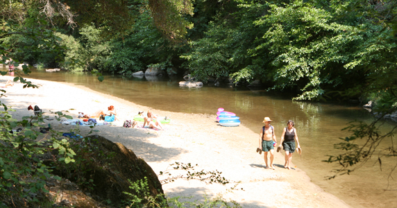
This wide sandy beach along the gently flowing San Lorenzo River is a summertime oasis offering sun, shade and relative solitude. Photo courtesy of WeekendSherpa.com/Brad Day
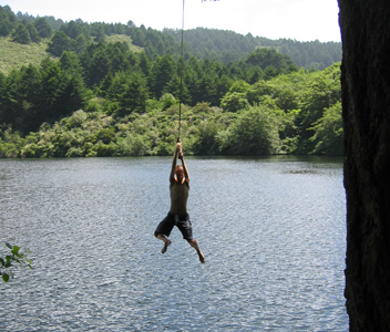
The famous up-again, down-again rope swing at Bass Lake in Point Reyes National Seashore. Photo courtesy of WeekendSherpa.com/Brad Day
