It’s harvest time in Napa. Celebrate the region’s wild side with three big-view hikes and two under-the-radar wineries. Hike, sniff, swirl, and sip. Repeat as needed.
A spectacular view of green hills and vineyards from the overlook at Table Rock Trail. Photo by Brad Day/WeekendSherpa.com
By weekendsherpa.com
Published: October, 2008
Table with a View
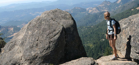
For a little hike with big views, pack the wine and cheese and head for Table Rock Trail in northern Napa’s Robert Louis Stevenson State Park. The shaded trail rises moderately for 1 mile before reaching an overlook with pop-up-book vistas of green hills and vineyard-latticed valleys, not to mention the Mayacamas Mountain Range. Simply sit back and savor the views or scramble over and around the overlook’s Volkswagen-sized boulders before returning the way you came. Afterwards, visit one of the best mom and pop wineries in Napa—Vincent Arroyo. While many boutique Napa wines start at $50 a bottle, Vincent Arroyo’s prices average in the low $30s. The two resident black labs, JJ and Bodega, will welcome you to this off-the-beaten-path winery that’s been making award-winning petite syrahs since the early ‘80s. Vincent Arroyo tastings are generally by appointment, but don’t let that stop you—they happily welcome drop-ins, too.
TIP: Hikers with good shoe-traction and plenty of water can continue another 1.3 miles to the trail’s namesake destination—Table Rock, a high-in-the-sky exposed flatbed of volcanic rock with 360-degree views. (Be forewarned: Trail markings are sparse.)
To reach the Table Rock Trailhead: From Calistoga, travel north on Hwy 29 for 7 miles. The turnout for parking is on the right side of the road, .25 mile after the Robert Louis Stevenson State Park sign. It can get extremely hot in the summer and into early fall; it’s best to hike in the morning. No dogs.
Vincent Arroyo Winery, 2361 Greenwood Ave., Calistoga; 707-942-6995. Open 7 days a week from 10:00 a.m. to 4:30 p.m. Tastings are complimentary, unless you have a group of seven or more; then it is $5 per person. Greenwood Ave. is off of Hwy. 29; .7 mile north of the intersection with Silverado Trail.
Bald Beauty
For one of the biggest, most spectacular views of Napa, head to Sonoma. That’s right. Bald Mountain in Sugarloaf Ridge State Park offers worlds-away views that straddle two of the world’s premier wine-growing valleys. On clear days, the peaks of the Sierra Nevadas glint on the horizon and Mount Saint Helena looks close enough to touch; below, the golden hills and green valleys of Napa and Sonoma roll away. Descend via the same route, or make a partial loop by dropping down Gray Pine Trail to a mostly canopied section that crosses a creek, dips through forests, and pops out onto an open ridge with broad views. On the drive back, toast your successful ascent with a stop at Kaz, the smallest—and quite possibly the friendliest—winery in Sonoma. (The winery closes at 5:00 p.m., so be sure to time your hike accordingly.) Richard Kaz Kasmier is the big guy at this family-run winery, which makes only 60 barrels of delicious organic wine a year. Buy one of their uniquely labeled bottles and Kaz will happily sign it for you.
With numerous stretches of exposed trail, this hike is best done in the milder temperatures of spring or fall. To reach Sugarloaf Ridge State Park: From Highway 12 in Sonoma Valley, go east on Adobe Canyon Rd. in Kenwood. Drive 3.5 miles to the park entrance. The trailhead is at the back of the left-side parking lot. Hike about 1 mile on Lower Bald Mountain Trail; continue up the paved Bald Mountain Trail for 1.5 miles. At the end of the pavement, turn right and continue on the Bald Mountain Trail. The trail curves around the summit; turn right on Gray Pine Trail and take a spur trail to the summit. Descend the way you came, or continue down the Gray Pine Trail .8 mile to Red Mountain Trail. Turn right and go about 1 mile to the Headwaters Trail; turn left. Go .5 mile to the Vista Trail; turn right. Go about .5 mile until it connects back with the Bald Mountain Trail. The park may not have maps; print one out beforehand from www.parks.sonoma.net/sugarloafmap.html. Allow four to five hours for the hike. No dogs.
Kaz Vineyard & Winery , 233 Adobe Canyon Rd., Kenwood; 877-833-2536. Open Friday to Monday from 11:00 a.m. to 5:00 p.m. Tastings are $5.
Redwood Respite
Escape Napa’s hustle and bustle via a little slice of open space filled with some of the easternmost coastal redwood trees in the state. Located just north of St. Helena on Napa Valley’s busy Highway 29, Bothe-Napa Valley State Park features a hiking loop with lots of variety and rewarding views. Start the hike alongside Ritchey Creek, where redwood groves and large maple trees with autumn-gold leaves shade the way. The path eventually veers and rises steadily; near the summit, the trees give way and the trail becomes exposed. The best views are from just below Coyote Peak, where a break in the forest creates a wide-angle panorama of St. Helena and the Vaca Mountain Range. Complete the loop by descending the south side of the peak, which links up again with the Ritchey Canyon Trail.
Bothe-Napa Valley State Park is located 5 miles north of St. Helena on Hwy. 29. The Coyote Peak loop trail is about 4.5 miles. Park at the trailhead, on the right of the road just past the visitor center. Start hiking on the Ritchey Canyon Trail. Follow this along Ritchey Creek until you reach Redwood Trail. Follow this to the Coyote Peak Trail. A signed spur trail goes to the summit. After taking the spur trail, continue on the Coyote Peak Trail to the South Fork Trail and go right. Cross Ritchey Creek, and turn right on Redwood Trail. Cross the creek again to Ritchey Canyon Trail and continue all the way back to the parking lot. Dog are allowed in the park, but not on the trails.
29-year-old WeekendSherpa.com founder and managing editor Brad Day grew up in California and has spent his entire life adventuring in Northern California’s great outdoors. WeekendSherpa.com is a San Francisco based online publication that sends out a free weekly (Thursdays) email newsletter giving insiders’ information on enjoyable and economical things to do in the Bay Area/Northern California outdoors, including hiking, biking, and just plain relaxing...as long as it gets you out there! www.weekendsherpa.com.
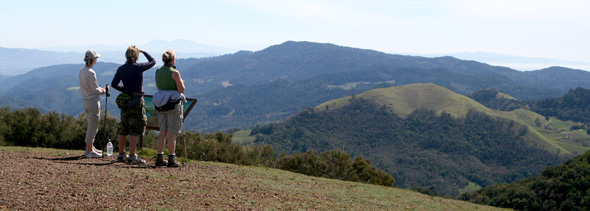
Bald Mountain in Sugarloaf Ridge State Park. Photo by Brad Day/WeekendSherpa.com
