Covering 740 acres and rising to a height of almost 800 feet, Angel Island is the second-largest island in San Francisco Bay—only Alameda is larger.
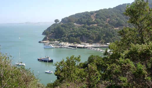
From 1891 until 1947, Ayala Cove— then known as Hospital Cove—was used as a quarantine station. Photo by Joel Williams
By Captain Ray
Published: March, 2009
Covering 740 acres and rising to a height of almost 800 feet, Angel Island is the second-largest island in San Francisco Bay—only Alameda is larger. This month and next, I’d like to relate the story of Angel Island’s varied history to you.
During the last ice age, which ended about 10-12,000 years ago, the area that is now San Francisco Bay was a large coastal valley, rich with rivers and dotted with hills. This valley is a downward deflection of the earth’s crust between the San Andreas Fault to the west and the Hayward Fault to the east. With each earthquake, it settles a little more. (In 1989, the Loma Prieta earthquake caused the bay to become approximately three inches deeper.) As the ice age ended, sea levels rose and the ocean flooded this valley; one of the hilltops is now Angel Island.
The first humans to visit the island were the Miwok. It is unknown if the Miwok had permanent villages on the island; however, there were temporary camps at several locations around the island used seasonally to hunt deer, otters, seals, and sea lions, collect shellfish, fish for salmon, and gather acorns and other seed crops. Evidence of Miwok presence has been found at Ayala Cove, China Cove, Camp Reynolds, and Fort McDowell.
In November 1769, Gaspar de Portola sighted San Francisco Bay from the crest of the Santa Cruz Mountains. Lt. Juan de Ayala, sent from Mexico to explore and chart the bay, passed through the Golden Gate in August of 1775. He anchored his ship, the San Carlos, on the north side of Angel Island in the cove that now bears his name. This is believed to have been the first European contact with the island. He named it Isla de Los Angeles (Island of the Angels). In doing so, he was following the Spanish explorers’ common practice of naming places after the closest religious feast day to the discovery.
Little was done with the island during the early nineteenth century, although it did serve as a cattle ranch. After the Mexican-American War in 1846, illegal settlers squatted on the ranch, and sandstone—quarried on the east side of the island—was used for construction around the bay. That area is known today as Quarry Point.
With the advent of the Civil War (1861-1865), the long history of military fortifications on Angel Island began. There was fear that the Confederacy would try to disrupt the flow of gold and silver from the Sierra Nevada or attempt an attack on military facilities inside the bay. If Confederate ships were able to get into the bay, the arsenal at Benicia and the navy yard at Mare Island would be vulnerable. Camp Reynolds was constructed on the west shore along with batteries at Point Stuart, Point Knox, and Point Blunt. After the war, the fort was transformed into a recruit depot; it also served as an operations base during the Indian Wars. In 1886, more batteries were constructed on the southwest side of the island to defend the Golden Gate.
From 1891 until 1947, Ayala Cove—then known as Hospital Cove—was used as a quarantine station. Ships arriving from overseas were fumigated with live steam and their immigrant passengers inspected for disease. An old warship, the USS Omaha, was moored in the cove to provide the superheated steam. Many buildings were constructed, including laboratories, staff housing and a 400-bed detention barracks. It was in these barracks that the passengers waited until their 14-day quarantine was over. After the quarantine station was abandoned, most of these structures were torn down. However, the old bachelor officers quarters is now used as the state park museum.
Next month, I’ll talk about the ways Angel Island has been used in the twentieth century, including the immigration detainees, prisoners of war, and Nike missiles.
Ray Wichmann,
is a US SAILING-certified Ocean Passagemaking Instructor, a US SAILING Instructor Trainer, and a member of US SAILING’s National Faculty. He holds a 100-Ton Master’s License, was a charter skipper in Hawai’i for 15 years, and has sailed on both coasts of the United States, in Mexico, the Caribbean, and Greece. He is presently employed as the Master Instructor at OCSC Sailing in the Berkeley Marina.