For most of us, the only time we might think about Yerba Buena Island is while we’re driving through the tunnel that connects the eastern and western spans of the Bay Bridge.
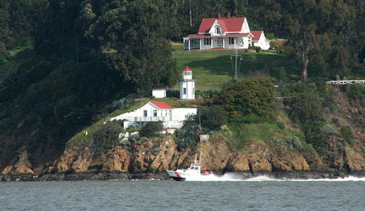
The unique octagonal lighthouse and the fog signal—still operational on the southern end of the island—were completed in 1875. The beautiful house just above these installations was constructed for the lighthouse keeper and now serves as the home of a Coast Guard admiral. Photo courtesy of USCG
By Captain Ray
Published: May, 2009
The first interesting part of its history is the island’s name. The derivation of the name Yerba Buena, a variant of hierba buena (meaning ‘good herb’ in Spanish), is from the common name of a mint plant that grew abundantly in the area, including the steep slopes of the island. The first California legislature, meeting in 1850, included the island within the boundaries of San Francisco County and at that time, they gave it the name Yerba Buena, which had been the name of San Francisco until 1847. In 1895, however, the United States Geographic Board changed the name to Goat Island, because Captain Gorham Nye had, decades earlier, stocked the island with goats that he sold to visiting vessels. Because the local populace continued to use the name Yerba Buena, the Board reversed itself and officially restored the island’s name in 1931. Before all of that, early Spanish settlers called it Sea Bird Island, and, in his book Two Years Before the Mast, Richard Henry Dana referred to it as Wood Island.
The military considered fortifying the island during the Civil War. There was concern that on some dark and foggy night, Confederate ships might be able to slip past the cannons at Fort Point and Alcatraz and into the bay. However, nothing ever came of this idea. Instead, aids to navigation became more important, and the unique octagonal lighthouse and the fog signal—still operational on the southern end of the island—were completed in 1875. The beautiful house just above these installations was constructed for the lighthouse keeper and now serves as the home of a Coast Guard admiral (see photo).
In the early 1930s, a quite remarkable tunnel was bored through Yerba Buena Island to connect the two spans of the Bay Bridge. While only slightly more than a quarter-mile long, it is one of only a very few double-decker tunnels in the world, and it has the largest diameter of any vehicular tunnel in the world. The Works Progress Administration utilized the stone quarried from the tunnel in the construction of Treasure Island.
The east shore of the island was once the site of a Native American fishing village. Today it is the home of a United States Coast Guard Base. From its docks, the Coast Guard dispatches 225-foot seagoing buoy tenders to maintain aids to navigation from the Oregon to the Mexican borders. Like all Coast Guard vessels, they display the distinctive blue, white and orange bow stripes, but these tenders are quite distinctive. Unlike all other Coast Guard vessels that are painted white, buoy tenders are painted black (see photo). Look for them the next time you cross the Bay Bridge or pass close the Yerba Buena Island on the ferry.
Sitting atop the island is a complex of antennas that are used by the Vessel Traffic Service (VTS). This complex was established in 1972 to “provide active monitoring and navigational advice for vessels in particularly confined and busy waterways.” Of the 12 VTS systems now operating within the United States, VTS San Francisco was the first to be established. Using a system of radar installations, video cameras and reports from the vessels themselves, VTS monitors shipping throughout the San Francisco Bay, the Delta, and the offshore approaches to the Golden Gate. VTS also broadcasts a “vessel traffic report” on marine radio every half hour.
Smile! The ferry you’re riding is being monitored by VTS as you read this.
Ray Wichmann, is a US SAILING-certified Ocean Passagemaking Instructor, a US SAILING Instructor Trainer, and a member of US SAILING’s National Faculty. He holds a 100-Ton Master’s License, was a charter skipper in Hawai’i for 15 years, and has sailed on both coasts of the United States, in Mexico, the Caribbean, and Greece. He is presently employed as the Master Instructor at OCSC Sailing in the Berkeley Marina.
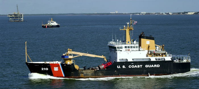
From US Coast Guard docks on the east side of Yerba Buena Island, 225-foot seagoing buoy tenders are dispatched to maintain aids to navigation from the Oregon to the Mexican borders. Unlike all other Coast Guard vessels that are painted white, buoy tenders are painted black. Photo courtesy of USCG
