The 23rd Annual Bay Area Decisionmakers Conference brought together experts, advocacy groups, business leaders, and representatives from a number of state regulatory agencies to discuss California’s preparations for the 16-inch increase in sea levels expected by 2050 due to climate change.
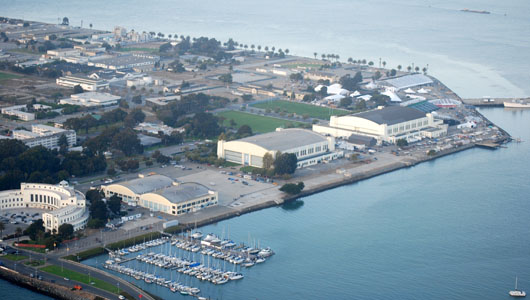
Engineers have factored sea level rise into planning developments for Treasure Island. Photo by Joel Williams
By Bill Picture
Published: May, 2010
The one-day event, held last month in Oakland, provided its 300-plus attendees with a unique opportunity to learn about new policies taking shape—including a Governor-mandated adaptation plan—that will affect new and existing development along California’s 840 miles of coastline. The conference was organized by the Bay Planning Coalition, a coalition-building group working to help strike a balance between commerce, recreation and environmentalism in the Bay Area.
“Sea-level rise is an especially important issue in the Bay Area,” says Thayer of the California State Land Commission. “Most of the communities here have waterfront, and the shoreline per capita rate is high, so the potential for impact is definitely up there.”
Slowing down the process was the fact that, until recently, there was no consensus among the scientific community about the exact rate of sea-level rise. Without a solid number to work with, there was no way of knowing just how serious the impact on affected communities would be. Thus, those communities were afraid to take action, as that action could end up not being good enough.
While predictions still vary, a 16-inch increase by 2050, with an additional 39 inches by 2100, are agreed upon by enough scientists that state and local agencies can begin planning accordingly.
Where is the water coming from?
The sea level fluctuates naturally. However, that rate of increase appears to be quickening. The reason for that, according to scientists, is the man-made warming of the Earth. Higher temperatures are expanding ocean water and melting glaciers. As a result, the seas are rising.
“Even if you don’t believe that climate change is real, or that climate change has anything to do with sea-level rise, there’s no arguing with the fact that the sea level is rising,” says Matthew Heberger, Research Associate at the Pacific Institute. “We have the numbers to prove it.”
The San Francisco Bay is home to the longest continually operating tide gauge in North America. According to that gauge, the water in the Bay has risen about eight inches over the last one hundred years.
“And any oceanographer you talk to will tell you that the rate at which it’s rising is picking up,” Heberger adds. “More and more evidence is coming in, and it’s definitely getting worse.”
So what is going to happen?
The truth is, no one is exactly sure. However, the long list of possible scenarios is enough to make anyone look for higher ground.
Naturally, any structure built at or below sea level is vulnerable. Large portions of Santa Clara County are already below sea level, some as much as thirteen feet; and San Francisco’s entire Embarcadero is currently at sea level.
“So it doesn’t take much to figure out what could happen if the sea level continues to rise,” says Joe LaClair, chief planning officer for the San Francisco Bay Conservation and Development Commission, which oversees development along the San Francisco Bay shoreline.
It’s doubtful that homeowners along the coast will step out of bed one morning and into a foot of water. Storm-driven flooding is a much likelier scenario. In a report to Congress, the Federal Emergency Management Agency (FEMA) estimated that, for every one foot that the sea level rises, coastal communities can expect 36 – 58 percent more damage annually due to storm flooding due to increases in the sizes of flood plains.
“Every time the sea level rises, so does the flood risk,” says Matthew Heberger of the Pacific Institute. “And climatologists are predicting that storms will become more and more intense, so we better do something,” adds LaClair.
Surface water and ground water are likely to increase in salinity as the sea level rises. Estuaries would also be affected, as some aquatic plants and animals cannot tolerate high salinity.
Some wetlands and mudflats could be lost. It will depend on whether sediment deposit can keep up with the rising sea level, which is nearly impossible to predict. The loss of these areas would certainly affect bird migratory patterns, as the Bay Area is a key stop along the Pacific Flyway. (For a detailed discussion of climate change’s impact on Bay wetlands, see page 14.)
“There’s a lot of uncertainty surrounding what’s going to happen. There’s a lot we don’t know,” says LaClair. “Nevertheless, these are possibilities that we have to confront now. We have to take a look at all of the risks and devise strategies for adapting based on what we do know.”
Adapting to change
Taking the scientific evidence of sea-level rise to heart, many Bay Area cities have already begun planning for that inevitability. For instance, the city of Mountain View, which wishes to intensify development on the bay side of Highway 101, is updating its general plan to reflect the rising sea level. Similar things are happening in the city of San Leandro, and engineers have factored sea level rise into planned developments on Treasure Island and at the former Hunter’s Point Naval Shipyard.
“Based on the assessed risk, some communities might decide to build levees or seawalls, or reinforce existing ones to protect existing developments,” says Thayer of the California State Land Commission. “In some cases, it may even be necessary to relocate existing developments or declare portions of shoreline off-limits to new development.”
That might sound extreme, but North Carolina has already stopped allowing homes to be built on shoreline property that is likely to erode within the next 30 to 60 years. In Maine, Rhode Island, South Carolina and Texas, such a home can be built, but only on the condition that it will be removed by its owners if threatened by the advancing shoreline.
“The Ocean and Coastal Resources section of the California Climate Adaptation Strategy basically says that it’s not a good idea to build stuff at sea level anymore,” says Sam Schuchat, executive officer of the California Coastal Conservancy. That strategy, which was created by a number of state agencies under order by Governor Schwarzenegger, provides recommendations on how to manage the threats posed by climate change.
“I mean, really, if you’re proposing to build something or restore something, regardless of what the project is or how big it is, you should be thinking about how climate change is going to affect that project in the future,” Schuchat adds. “That should be a part of the planning process from here moving forward.”
“The goal of the conference was to present as many different perspectives on this issue as we could,” says Ellen Joslin Johnck, executive director of the Bay Planning Coalition. “I think we achieved that. We brought a lot of different people together—government officials, community leaders, developers and business people. And everyone walked away with an understanding of what’s going on and what needs to be done. We have to pay attention and develop some short term and longer term actions for adapting to and mitigating this problem.”
For more information on the Bay Planning Coalition, visit www.bayplanningcoalition.org.
To read the California Climate Adaptation Strategy, visit www.climatechange.ca.gov/adaptation/.