Bay Crossings was invited to attend the 23rd annual San Francisco Bay Decisionmakers Conference, “Climate 3.0 – Policies and Decisions for a Changing Landscape,” that took place last month in Oakland.
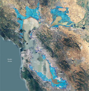
This map, provided by BCDC, depicts areas vulnerable to 16 inches of sea level rise (light blue) predicted by mid-century and 55 inches (purple) predicted by the end of the century.
Published: May, 2010
Bay Crossings was invited to attend the 23rd annual San Francisco Bay Decisionmakers Conference, “Climate 3.0 – Policies and Decisions for a Changing Landscape,” that took place last month in Oakland. An in-depth article by Bill Picture on the critical issues covered at the conference appears on the following two pages.
As an introduction to that story, we would like to present the opening remarks of Will Travis, executive director of the San Francisco Bay Conservation and Development Commission (BCDC), during a panel discussion on regulations and emerging policies to meet the challenge of a rising sea. Shown behind Travis, as he addressed the audience, was a slide with the following three quotes: “Jim Lovell was right,” “Albert Einstein was right,” and “H.L. Mencken was right.”
Here’s what the first point on my slide means. James A. Lovell was a member of Apollo 13, which was heading to the Moon exactly 40 years ago yesterday. When the spacecraft lost electrical power and both oxygen tanks failed, Lovell radioed NASA’s mission command on Earth to report, “Houston, we have a problem.”
This was a classic understatement of a potentially catastrophic emergency. Ultimately, through a combination of team work, imagination and thinking way outside the box, the crew returned to Earth, and the mission was deemed a “successful failure.” With hundreds of square miles of diked, filled and subsided land surrounding San Francisco Bay, most of it near or below current high tide elevations, accelerated sea-level rise in the future means, “Bay Area, we have a problem.”
BCDC is amending our Bay Plan to include sea-level rise policies that will guide the Commission in making its regulatory decisions and also be part of an integrated regional climate change strategy that sets high performance goals and then encourages collaboration, imagination and innovation to come up with the best way of meeting the goals.
As for the second point, Albert Einstein was a smart guy who said lots of brilliant things including this statement which is most relevant to the challenge we’re facing: “The world we have created today, as a result of our thinking thus far, has problems that cannot be solved by thinking the way we thought when we created them.”
In other words, we need to begin thinking in all new ways. Engineering approaches that rely on certainty won’t work in an uncertain future. Laws that mandate us to do certain things to deal with the problems of the past will need to be changed to deal with the problems we’ll face in the future. We’ll need to come up with new ways of planning, building and living in areas that are above sea level today, but will surely slip below sea level over the next century.
It’s folly to think we can build levees high enough and strong enough to prevent flooding from ever-rising seas and storms forever. But it’s equal folly to think we can restore the Bay ecosystem the way it was in the past. Instead, we need to design the Bay so it can adapt to the changes that will inevitably come about in the future.
Turning to the third point, among H.L. Mencken’s many oft-quoted remarks is this one: “For every complex problem there is an answer that is clear, simple and wrong.”
One strategy for cutting greenhouse gas emissions in the Bay region is to reduce the need to drive by encouraging more compact, mixed-use in-fill development along transit corridors. One strategy for dealing with sea-level rise is to begin a planned retreat from areas vulnerable to future flooding. However, some of these low-lying areas have existing development and transit. In the long term, it isn’t a good idea to put more development in areas we have to protect from flooding. But in the short term, that may be a good way to reduce driving.
So in some vulnerable areas, development may be appropriate. In others, it won’t. In some places we may want to start thinking about removing existing development and replacing it with wetlands as part of a planned retreat. No single approach will work everywhere.
That’s why we should begin developing a new Bay Plan created by working together as a region to decide where we will invest in shoreline protection, where we will concentrate on habitat enhancement, and what strategies we should adopt to bring us true sustainability in the face of rising seas, increased storms, hotter weather, more wildfires and a vastly different climate in the future.
As for my key take-home message, it’s this map (see photo) showing what rising sea levels could make our region look like a century from now, when 332 square miles of shoreline land will be flooded, causing at least $60 billion in damage to public and private development, including the homes of 270,000 people.
A half a century ago, another map illustrated what the Bay could look like if the historic trend of Bay filling continued. It showed that the Bay would become little more than a wide river. That map alarmed the citizens of the Bay area and inspired them to prevent that unwanted future from coming about. We hope our map will provide the same inspiration.
This isn’t the future we are predicting; this is the future we’re trying to prevent. Together we can shape our destiny by acknowledging we’re facing a serious problem, by embracing a nuanced approach for dealing with the problem rather than dogmatically advocating any single silver bullet solution, and by thinking about the problem in all new ways.
