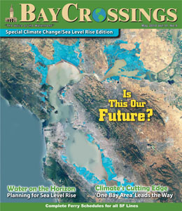
This map depicts the regions of the Bay Area that will be underwater in 2050 if the sea level rises as predicted. The 23rd Annual Bay Area Decisionmakers Conference, covered extensively in this issue, focused on finding solutions to help the Bay Area plan for the watery future and brainstorm ways to prevent it. See pages 9 - 15 for our special section on climate change. Map provided by the San Francisco Bay Conservation and Development Commission
Published: May, 2010
