Yes, San Francisco Bay is a beautiful place to sail! Views of the East Bay hills, Tiburon and Mt. Tamalpais behind, the bridges, and the City climbing up and down the hills are spectacular.
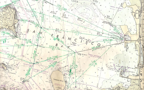
Notes made on navigation charts can be used to plot courses and distances between frequently used locations when “buoy hopping.”
By Captain Ray
Published: July, 2010
Yes, San Francisco Bay is a beautiful place to sail! Views of the East Bay hills, Tiburon and Mt. Tamalpais behind, the bridges, and the City climbing up and down the hills are spectacular.
On a beautiful sunny day, navigating on San Francisco Bay is also a very visual affair. You can see where you want to go (or at least to the next course change), and hazards and obstacles are easily spotted. Even the strength and direction of the almost ever-present current can be determined by just looking around, if you have a little bit of experience.
Even at night, navigation on the Bay is mostly visual. You look for the lights of buoys and lighthouses, and you consult your chart to identify the light patterns of these various aids to navigation. Sometimes this can be difficult because of the millions of people living around the Bay and the background light created by house lights, street lights and such. In order to traverse the Bay safely, nighttime sailors also look to see the lights of ships—or, even more commonly, the moving “black hole” where a ship blocks the background light.
“Naviguessing” changes dramatically, though, when thick fog blankets the Bay. Vision is our species’ primary sense mode and, when removed, we often become disoriented. The aid of a compass is comforting, but the lack of familiar visual landmarks is still unsettling. Holding a steady course can be challenging. With training and practice, you will improve in holding that course, but there is often some small error, and the error can be cumulative. If you are only one degree off course, after sailing one mile your position will be in doubt by plus or minus 100 feet. But, no one can steer within one degree! Even the very best sailors are only able to hold course within plus or minus three degrees. Because of these steering constraints, the uncertainty of our position grows as the length of the course increases. Some way of dealing with this ever growing uncertainty is needed.
One way is to break up these long courses into a series of short legs—that is, to reduce the amount of uncertainty in your position by decreasing the length of each leg. The name given to this technique is “buoy hopping,” because it is common practice to use buoys as checkpoints along the way. The Bay has many buoys and other aids to navigation that make this technique quite feasible.
I have used this trick successfully many times. To make this technique as quick and easy as possible, I usually carry a chart on which I’ve noted the courses and distances between frequently-used locations, useful buoys, and other aids to navigation. It is true that using this procedure will result in a longer and more circuitous route home. The additional time pays for itself, however, with a significant increase in safety and the skipper’s feeling of comfort.
Electronic aids to navigation, such as GPS, have greatly reduced the risk to mariners operating in restricted visibility and provide a much greater sense of comfort. Still, in the past several years I have seen two GPS units dropped over the side. They may well have been waterproof, because the lights were still on as they disappeared. In a situation like this, it’s smart to have simple, tried and true options, like a chart and compass, available.
Ray Wichmann, is a US SAILING-certified Ocean Passagemaking Instructor, a US SAILING Instructor Trainer, and a member of US SAILING’s National Faculty. He holds a 100-Ton Master’s License, was a charter skipper in Hawai’i for 15 years, and has sailed on both coasts of the United States, in Mexico, the Caribbean, and Greece. He is presently employed as the Master Instructor at OCSC Sailing in the Berkeley Marina.
