December and January have produced phenomenal amounts of rain, and the Delta has definitely received her fair share.

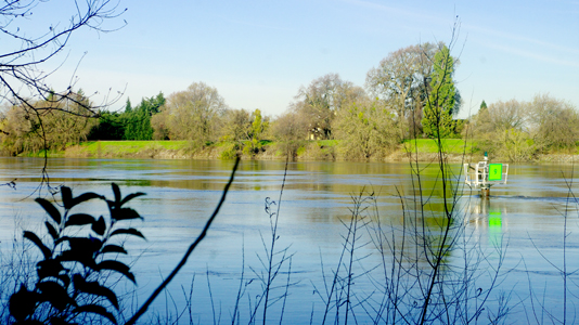
Under normal conditions, an additional 7-10 feet of this channel marker would be visible on the Sacramento River at the north end of Clarksburg. Photo by Jah Mackey
By Jah Mackey
Published: February, 2011
December and January have produced phenomenal amounts of rain, and the Delta has definitely received her fair share. Last month as I was wandering around enjoying the Delta, I was pleasantly surprised to see the banks of the San Joaquin and the Sacramento rivers bulging with runoff from this year’s most recent downpours.
Every year I hear reports of safety issues surrounding levee maintenance and concerns about possible levee breaks. After photographing the swollen river, my curiosity was piqued and I decided to investigate.
According to the National Weather Service, Clarksburg gets 17 inches of rain per year, well below the U.S. average of 37 inches. I chose Clarksburg as my starting point because the river was higher than I had ever witnessed there, and it was very close to one my favorite watering holes, The Old Sugar Mill. This year the rainfall and subsequent runoff seem far greater than normal, with experts predicting El Nino’s return for the 2010-2011 rainy season.
So, what does this mean for those concerned about their homes and jobs protected by the massive Delta levee system? Well, in the aftermath of Hurricane Katrina, the Army Corps of Engineers, the Department of the Interior, the EPA and many other government organizations embarked on a campaign to enforce levee standards more vigorously. Several reports, press releases and media advisories in 2007 announced new policies and programs to address many aspects of the overall problem.
In particular, the Corps of Engineers developed a heightened awareness with their partner agencies in the western United States generally and in the Delta region specifically, as the Delta presents many unique issues around the environment, agri-business, endangered species, history, water rights and the local economies that have set a precedent for other levee systems across the country.
A Department of the Interior publication, “Anticipating California Levee Failure,” focuses on the nightmare scenario of a levee breach due to inherent conditions of subsidence combined with a massive earthquake and the resulting oil spills from refineries along the river like those located next to the Port of Stockton.
According to the publication, the Delta has over 1,100 miles of levees. While they provide full protection from flooding, they are at risk from increased rains during the winter months, which can affect the levees’ ability to contain rising waters. All levees are designed to provide a specific level of protection, and can be overtopped, or fail, in larger flood events. Levees also require regular maintenance to retain their level of protection. Over time, this maintenance can become a serious challenge.
In more technical terms, a levee’s main function is to oppose the hydrostatic force of water and frequency of tides. Levee failure is usually associated with the size of the levee and height of the water exerting force on it; levee vulnerability increases with subsidence and the length of the levee on which water pressure is acting. Subsidence decreases levee integrity by reducing lateral support and shear resistance and facilitating settling or deformation of peat layers beneath.
Holistic and Organic Solutions
Solutions to our levee problems have been emerging on several fronts. The Army Corps of Engineers’ vegetation management approach, which was proposed at a 2007 symposium, garnered joint support from members of the Corps, the California Department of Water Resources, the State of California Reclamation Board, the U.S. Fish and Wildlife Service, NOAA’s National Marine Fisheries Service, the California Department of Fish and Game, Reclamation District No. 2068, and the Sacramento Area Flood Control Agency.
Many of the ideas that came from the 2007 symposium—including the vegetation management plan, which involves stripping some levee vegetation to manage threats to levee integrity—have continued to this day as the California Levee Vegetation Research Program. The agencies agreed to work together to draft a phased system-wide plan, with short-term and long-term elements, that will include vegetation management requirements for Central Valley levees and adjoining channels.
This phased approach will give the State and local levee-maintaining agencies time to plan, design and finance more intensive levee maintenance and vegetation management programs. For more information on the California Levee Vegetation Research Program and the ongoing efforts to protect life along the river, please visit the websites of the aforementioned organizations as well as IFC International at www.icfi.com.

