The Bay Area’s far-flung network of more than two dozen separate transit agencies has been known to present more than a few navigational challenges, not only to visitors but even to longtime area residents making out-of-the-ordinary transit trips.
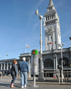
New signs at key Bay Area transit hubs are marked by a distinctive white i set in a bold orange circle. © 2011 Peter Beeler/MTC
By John Goodwin
Published: February, 2011
The Metropolitan Transportation Commission (MTC) is teaming with Bay Area transit agencies to install a standardized system of information displays at 21 key transit hubs throughout the region. The $10.2 million Hub Signage Program includes distinctive transit information displays, wayfinding signs and real-time transit departure indicators. Transit information displays and real-time departure times also will be installed at the San Francisco, Oakland and San Jose international airports.
Following the 2010 completion of a hub signage demonstration at the Embarcadero BART/Muni station in San Francisco, wayfinding signs and transit information displays are now being installed at the San Jose/Diridon, Mountain View, Palo Alto and San Francisco/4th and King Caltrain stations, the Fairfield Transportation Center, and the Santa Clara site occupied by Amtrak Capitol Corridor’s Great America station and the Santa Clara Valley Transportation Authority’s (VTA) Lick Mill station. Real-time departure displays will be added to these stations this fall.
“MTC is committed to making it easier and more convenient for Bay Area residents and visitors alike to use public transit for trips around the region,” said MTC Commissioner and Orinda City Councilmember Amy Rein Worth, who chairs the Commission’s Operations Committee. “As with the Clipper transit-fare payment card, the Hub Signage Program is a way to help knit the Bay Area’s more than two dozen separate transit systems into a true regional network.”
Funding for the Hub Signage Program includes $400,000 in Regional Measure 2 toll funds approved by Bay Area voters in 2004 and $9.8 million from the Proposition 1B transportation bond measure approved by California voters in 2006.
Subsequent phases of the Hub Signage Program will include installations at the 12th Street/Oakland City Center, Coliseum/Oakland Airport, Civic Center, Dublin/ Pleasanton, El Cerrito del Norte, Fremont, Millbrae, Montgomery, Pleasant Hill, Powell Street and Richmond BART stations; Golden Gate Transit’s San Rafael Transit Center; and the Vallejo Transit Center. New signage also is in the works for the soon-to-be-redeveloped Santa Rosa Transit Mall, a planned new transit hub in downtown Napa and the three major airports.
Wayfinding signs, which provide directions to transit and other services, are being installed at the entrances and exits of transit hubs — and at key decision points within the stations. Similar to signs used in airports, the wayfinding signs feature transit agency logos and other designs to help direct passengers. These signs are being placed overhead in BART stations, and may be mounted on poles or on walls in other locations.
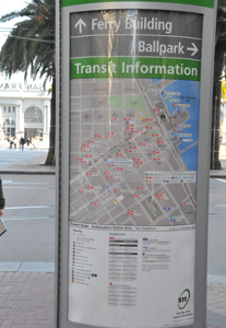
Transit information displays — marked by the distinctive, italicized white i (for “information”) set in a bold orange circle at the upper right corner of each panel — will be located at strategic sites similar to those selected for the Embarcadero BART/Muni demonstration, where three displays were installed. One is at the northeast entrance, adjacent to the cable car turnaround. Another is at the southeast corner of the station, with the third in the middle of the station opposite the Peet’s Coffee outlet. Each of the displays includes four printed panels: a station map; a route map showing the various bus routes serving the station; a map of nearby streets with bus stops clearly identified; and a panel showing transit fare and schedule information.
The white-on-orange “i” design also will be emblazoned on wayfinding kiosks placed in key locations with heavy foot traffic, and adjacent to real-time displays. The real-time displays will list the next three departures for all transit routes serving each hub. Work at all 24 locations is scheduled for completion by the summer of 2013.
A new wayfinding kiosk outside the Embarcadero BART/Muni station in San Francisco directs travelers to nearby transit services and major attractions. © 2011 Peter Beeler/MTC
