Offering spectacular views of the San Francisco skyline, the Marin Headlands and Mount Tamalpais, Angel Island is the largest island in San Francisco Bay. Local residents usually know where Angel Island is located—one mile south of the Tiburon Peninsula—but, surprisingly, most have never visited.
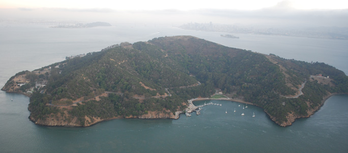
Angel Island is located one mile south of the Tiburon Peninsula but, surprisingly, most Bay Area residents have never visited this spectacular State Park right in our back yard. Photo by Joel Williams
Published: July, 2011
Offering spectacular views of the San Francisco skyline, the Marin Headlands and Mount Tamalpais, Angel Island is the largest island in San Francisco Bay. Local residents usually know where Angel Island is located—one mile south of the Tiburon Peninsula—but, surprisingly, most have never visited. Maybe that’s because the visitor’s center, in Ayala Cove on the north side of the Island, is only accessible by ferries or private boats.
Angel Island is a stunning, underutilized natural resource in the Bay Area, and Bay Crossings urges people to jump on a ferry boat this summer to visit this beautiful and historic island right in our own backyard. Over 13 miles of foot trails and fire roads circle the entire island. Trails lead to the 788-foot high summit of Mt. Livermore; eight miles of roadway are available for bike riding. Bicycles can be brought by ferry or rented and used on the island-circling Perimeter Road and the fire roads.
The island is alive with history. Three thousand years ago, it was a fishing and hunting site for Coastal Miwok Indians. It was later a haven for Spanish explorer Juan Manuel de Ayala, a cattle ranch, and a U.S. Army post. From 1910 to 1940, the island processed hundreds of thousands of immigrants, the majority from China. During World War II, Japanese and German POWs were held on the island, which was also used as a jumping-off point for American soldiers returning from the Pacific. In the 50s and 60s, the island was home to a Project Nike missile base. Finally, it became a State Park in 1954.
In a certain sense there are four completely different parks to see, each with its own identity.
The Quarantine Station and Ayala Cove
In 1775, Lt. Juan Manual de Ayala of the Royal Spanish Navy sailed into the Bay on the San Carlos, the first European ship to enter. He anchored in the cove that now bears his name, and spent over a month charting the Bay. Over a century later, in the early 1890s, the Marine Hospital Service, a branch of the federal government that has evolved into the U.S. Public Health Service, needed an isolated location to construct and operate a quarantine station to protect the west coast from contagious diseases traveling with passengers on ships sailing into the San Francisco Bay. The Marine Hospital Service constructed over 40 buildings in what was then known as Hospital Cove. Today all that remains are four of the original 40 structures.
Camp Reynolds
Established in September 1863, Camp Reynolds was named for one of the most beloved generals of the Union Army and the first general to be killed at the Battle of Gettysburg. Camp Reynolds—along with Fortress Alcatraz and Fort Point—was established to protect San Francisco from invading Confederate ships in search of guns and gold. Later, the camp was used during the 1870s as a training center for soldiers fighting in the Indian Wars. Today only a fraction of the original buildings exist, and the ones that have been protected serve as a reminder of California’s sometimes-overlooked importance during the Civil War.
East Garrison of Ft. McDowell
In about 1900, the miscellaneous military bases on Angel Island were reorganized into one base called Fort McDowell—named for the Civil War General Irvin McDowell. The facilities we see today at East Garrison were constructed by military prisoners from Alcatraz Island between about 1909 and 1910. The garrison was a model military base with all the pleasures of home—including a bowling alley, movie theater, hamburger stand, barber shop and a Wells Fargo office. During World War II, over 100,000 soldiers were processed going to and returning from the Pacific theater of the war, and soldiers’ letters have told us the food on Angel Island was the best they had at any base.
United States Immigration Station (USIS) and North Garrison
Located on the north side of Angel Island, the USIS opened in 1910 and operated until 1940, when a fire forced the closure of the site. During the 30 years it was in operation, over one million persons were processed on Angel Island. Sadly, the purpose of the site was to enforce the Chinese Exclusion Act of 1882, a law that prohibited most Chinese from becoming United States citizens. The immigrants who passed through the site had deep and agonizing experiences, and expressed these emotions by carving poetry into the walls of the detention barracks. The site was dedicated as a National Historic Landmark in 1997.
Angel Island is open from 8 a.m. to sunset all year and is accessible by ferries leaving from San Francisco, Tiburon, Alameda and Vallejo via transfer in SF (see ferry schedules on pages 24-25). Private boats can use the boat slips or the 27 mooring buoys at Ayala Cove. Slips, 30’ to 50’, cost $10. The California State Park Annual Day Use Pass, costing $125, can be used to pay dock fees. Mooring fees are $20 per night and can be used up to seven nights in a row. Slips and buoys are on a first-come first-served basis.

The Angel Island Ferry is a family owned operation that runs between Tiburon and Angel Island, about a 10-minute ride. Photo by Joel Williams
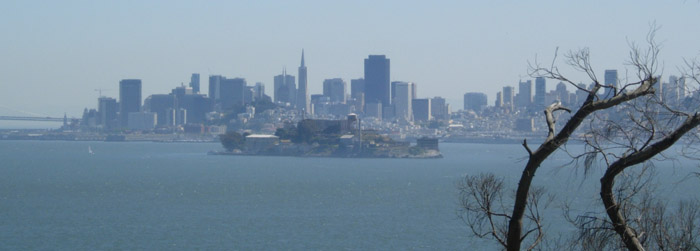
Some of the most breathtaking views of San Francisco’s skyline can be seen from Perimeter Road at the south end of the Island. Photo by Joel Williams
