Much of Mission Bay—several hundred acres sandwiched between San Francisco’s South of Market and Dogpatch neighborhoods on the north and south, and the San Francisco Bay and the Potrero neighborhood on the east and west—served as a railyard during the City’s days as a major working port.

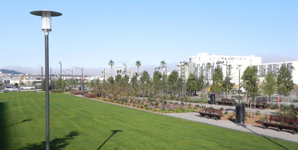
Last month, the team behind the redevelopment of Mission Bay unveiled P16, the newest section of a several-blocks-long chain of parks connecting 7th Street with 3rd Street and the waterfront. Developers report that people from other parts of The City have already begun traveling to Mission Bay to use its 41 acres of parks and open spaces.
By Bill Picture
Published: December, 2011
In November, the team responsible for the rebirth of San Francisco’s Mission Bay area unveiled two new pieces of the ongoing project—one finished and one nearly completed—that will further help connect a long-neglected part of San Francisco to both the waterfront and the rest of the City.
The San Francisco Redevelopment Agency, Mission Bay Development Group, the California Department of Toxic Substances Control, and the U.S. Environmental Protection Agency (EPA) led a tour of P16, one of several grassy stretches of Mission Bay Commons. The Commons is a several-blocks-long corridor that will eventually stretch from 7th Street to the San Francisco Bay.
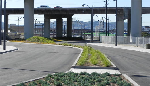
Guests also got a first peek at Mission Bay Circle, a landscaped turnaround that will eventually serve as a gateway to the park corridor and provide a secondary entrance for vehicles and pedestrians into Mission Bay from the west. For years, 16th Street provided the only access to Mission Bay from the west because of the I-280 freeway and Caltrain tracks. However, a new road will open in early-to-mid 2012 connecting Mission Bay Circle to 7th Street, providing a better link between Mission Bay to its neighboring district, Potrero.
“It’s pretty crazy how much is happening down there right now,” said Catherine Reilly of the S.F. Redevelopment Agency. “And the next wave of development is coming, so it was important to us to connect Mission Bay with the adjacent neighborhoods.”
An industrial past
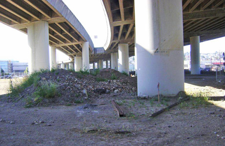
Much of Mission Bay—several hundred acres sandwiched between San Francisco’s South of Market and Dogpatch neighborhoods on the north and south, and the San Francisco Bay and the Potrero neighborhood on the east and west—served as a railyard during the City’s days as a major working port. But since the advent of containerization in the sixties and the shipping industry’s subsequent move across the Bay to the Port of Oakland, Mission Bay has sat largely idle.
Over the years, several new uses have been proposed for the area, which sits atop landfill. At one point, the City even considered building a large marina. But it was UCSF’s desire to expand within city limits and the booming biotech industry’s search for available real estate—along with the ever-present need for more affordable housing—that finally prompted action.
“It may look like this whole project came out of nowhere, but this is really the result of 20-plus years of planning,” said Reilly.
Like many former industrial areas, Mission Bay had contamination that needed to be remediated before new development could begin. Much of the landfill material underneath Mission Bay is rubble from the 1906 earthquake that contained some lead and asbestos, and topsoil contained additional harmful chemicals left behind by the area’s former industrial occupants.
Thankfully, the contamination was of such a low level that containment with a clean layer of topsoil was deemed the best course of action, thus qualifying the project for a Brownfield grant through the California Department of Toxic Substances Control and the EPA, with assistance from the Regional Water Quality Control Board. Brownfield grants are awarded for remediation of low-level contamination at former industrial sites proposed for reuse. The new layer of topsoil effectively serves as a cap on the contaminated soil underneath, which could otherwise be stirred up by winds or construction.
“Dealing with the contamination on-site was the best and safest remedy in this case,” said Tom Cota of the California Department of Toxic Substances Control. “Hauling away the contaminated material would be very expensive. Plus, where do you take it, to another landfill? And there are additional environmental impacts associated with trying to move it.”
More affordable housing, more open space, more jobs, little-to-no impact on the environment
When the project is completed in 2020, Mission Bay will include 6,000 market-rate and affordable housing units, 41 acres of new parks, and 30,000 new jobs, in addition to its four million square feet of commercial space. The development team says these were set as goals during the earliest stages of the planning process. So too, they say, were goals for minimizing Mission Bay’s environmental impact.
Mission Bay South features its own split sewer system to avoid further pressure on the City’s existing combined system. The network of sewer lines running under the rest of the City collect both wastewater and storm water, and send the combined flow to treatment facilities before it’s released into the Bay. To avoid backing up during heavy rains, the system is designed to release untreated overflow directly into the Bay. Mission Bay South will treat its wastewater and storm water on-site using traditional methods as well as bio-soils that filter out pollutants.
“They’re utilizing some really innovative methods,” said EPA Region 9 Brownfield Coordinator Noemi Emeric-Ford.
Permeable surfaces, including landscaped areas and a dozen-plus parks, help ease the strain on Mission Bay North’s combined system (part of the City’s existing network) by giving storm water somewhere to go other than the sewer.
All new construction in Mission Bay is subject to the City’s existing green building codes, which are some of the most stringent in the country. Still, those involved in the design and construction of Mission Bay’s various pieces are taking it upon themselves to go above and beyond the City-mandated green call of duty.
For instance, UCSF is shooting for LEED (Leadership in Energy and Environmental Design) Gold status for the 289-bed hospital complex it’s building in Mission Bay. That would make it the greenest hospital in the country. The hospital complex, which is scheduled to open in 2014, will include facilities specializing in the treatment of women, children and cancer patients.
Measuring success
“I think there are a few ways that we can define success here,” said Seth Hamalian of Mission Bay Development Group. “A big one is the sheer density of population in an area so well served by transit.”
But Hamalian says he’s even more proud of the fact that Mission Bay feels like a neighborhood. “For an area to be livable, you need several things: a grocery store, access to food—good food—and transit, retail, parks and plenty of open space,” he said. “I feel like we’ve succeeded on all of those fronts. In the case of the parks, we’re actually finding that people come to Mission Bay from other parts of the City.”
“There was a very deliberate effort made to balance housing and commercial so that Mission Bay feels just like the rest of the City,” added Phil Owen, President of Mission Bay Development Group. “There was an effort very early on to get in a grocery store. Now UCSF has a weekly farmer’s market. People feel like they have a reason to come to this part of town now, which they didn’t before. And that’s very exciting.”

Mission Bay used to be cut off from its neighbor, the Potrero district, by the I-280 Freeway and a set of Caltrain tracks, with 16th Street providing the only access to the area from the west. But a new road opening in early-to-mid 2012 will provide another way to get to Mission Bay from 7th Street, via the landscaped Mission Bay Circle turnaround.

Permeable landscaped surfaces like the Mission Bay Circle will ease the strain on The City’s combined sewer system during heavy rains by absorbing water that would otherwise flow into the sewers.

