The Bay Area’s 511 traveler information system is now offering its first smartphone app for transit riders.
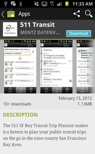
Appearing in the Android Market as 511 Transit, the new app was developed in conjunction with the Metropolitan Transportation Commission by the developer of the 511 Transit Trip Planner, Mentz Datenverarbeitung GmbH of Munich, Germany.
By Craig Noble
Published: April, 2012
The Bay Area’s 511 traveler information system is now offering its first smartphone app for transit riders. The free 511 Transit App is a multiple-agency public transit trip planner using GPS-based location tools for smartphones. Ideal for a daily commute, weekend errand or occasional trip, the app serves both residents and visitors who are planning transit trips within the nine-county region.
"We are pleased to offer this unique and powerful tool for transit riders in the Bay Area," said Adrienne J. Tissier, chair of the Metropolitan Transportation Commission (MTC). "Now you can use one app to plan trips on more than 30 public transit agencies, accessing the most complete coverage for the San Francisco Bay Area."
The free 511 Transit App is available both for the Android operating system, through Google Play (formerly the Android Market), and for the iPhone through the iPhone App Store using an iTunes account and by searching for "511 Transit." The new app provides door-to-door transit trip planning and scheduled departure times for transit routes near your location or from a location you specify. It includes information for 720 routes and more than 23,700 transit stops throughout the region. An interactive, dynamic map shows routes and stops along the way, as well as your current position while on the move. Walking directions to and from stops and fares (including transfers) are also displayed.
"Smartphones and on-the-go trip planning are becoming increasingly common, and 511 is now extending its Bay Area transit planning tools to these faster, more compact platforms," said Tom Spiekerman, 511 Transit project manager. "Currently, 511 customers plan more than one million transit trips per month using the popular website version of the 511 Trip Planner. The new app brings core features of this tool to customers on the go."
Additional app features include:
• Recently viewed locations and trips are saved automatically, as well as favorites.
• GPS positioning enables users to set their current location as a starting point for a trip, or to find nearby stops and transit routes with scheduled departure times.
• The app incorporates transit agency announcements that may affect a trip’s itinerary.
511 Transit App customers are able to provide feedback on the new app by clicking on the "Help/Info" button to send an email to the 511 Team.
The new app complements numerous options people already have to access 511 traveler information. Smartphone and other mobile phone users may access many of 511’s most popular features through the mobile 511 site (m.511.org), by calling 511 from any Bay Area phone, or by receiving real-time transit Departure Times texts (SMS). Desktop users can access the information from 511.org.
The 511 Transit App includes data from SF Muni, BART, AC Transit, VTA, SamTrans, Caltrain, Golden Gate Transit, County Connection, Vallejo Transit, LAVTA, Sonoma County Transit, VINE (Napa County) and more than a dozen additional agencies. For a complete list of all transit agencies included in the 511 Transit app, please visit the trip planning page at 511.org.
Apart from the new smartphone app, 511 is a one-stop phone and web source for up-to-the-minute Bay Area traffic, transit, rideshare and bicycling information. It’s free of charge and available 24 hours a day, seven days a week from anywhere in the nine-county Bay Area. 511 is managed by a partnership of public agencies led by the Metropolitan Transportation Commission, the California Highway Patrol, and the California Department of Transportation.
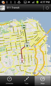
The 511 Transit app provides easy-to-read maps to help riders navigate the region on transit.
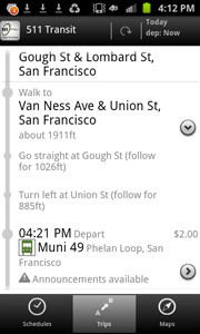
Using GPS technology, the 511 Transit app includes detailed walking directions to the appropriate bus stop, train station or ferry landing.
