On April 24, the Port of San Francisco will celebrate its 150th anniversary. On that day in 1863, the port was established with the legislature’s creation of the State Harbor Commission, which oversaw development of the port, including the building of the seawall that continues to serve our great City today.
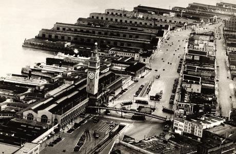
The Port of San Francisco’s Ferry Building and Embarcadero circa 1927. Photo courtesy of the Port of San Francisco
Published: April, 2013
On April 24, the Port of San Francisco will celebrate its 150th anniversary. On that day in 1863, the port was established with the legislature’s creation of the State Harbor Commission, which oversaw development of the port, including the building of the seawall that continues to serve our great City today. For perspective, the port’s history began just following the gold rush during President Lincoln’s first term, and during the Civil War.
The Port of San Francisco is a public agency responsible for managing the 7.5 miles of San Francisco Bay shoreline stretching from Hyde Street Pier in the north to India Basin in the south. The port’s responsibilities include promoting maritime commerce, navigation and fisheries; restoring the environment; and providing public recreation. More than 1,000 acres fall under its jurisdiction.
Beginning in April and throughout the remainder of 2013, the port plans to have events and activities on the waterfront, and throughout the City, that highlight the port’s rich maritime and cultural history and showcase the vibrant "people port" that it has become today.
With the gold rush attracting hundreds of ships to San Francisco Bay from around the world, the State Harbor Commission was created to improve the City’s harbor. As the City moved into the 20th century, the port grew in leaps and bounds. The waterfront became an industrial area of finger piers, railroad terminals and warehouses. With the outbreak of World War II, San Francisco became a military logistics center; troops, equipment and supplies left the port in support of the Pacific theater. The City’s shipbuilding and ship repair industries flourished. In the 1950s, San Francisco continued to be the West Coast’s premier cargo port.
In 1968, the State transferred its responsibilities for the San Francisco waterfront to the City and County of San Francisco through the Burton Act. As a condition of the transfer, the state required the City to create a commission that has the authority to manage the San Francisco waterfront for the citizens of California. Although the port is a department of the City and County of San Francisco, the port receives no financial support from the City, and relies almost solely on the leasing of Port property for its revenues.
Over the last 30 years, as the City’s downtown grew towards the water’s edge, new uses established themselves in previously industrial areas. The port today oversees a myriad of maritime, commercial and public activities. While at one time industrial maritime uses dominated the northern edge of the City, today cargo shipping and ship repair are located primarily south of China Basin. Cruise ships, excursion boats, passenger ferries, recreational boating, commercial and sport fishing activities and other commercial maritime operations remain on the northern waterfront which, because of its scenic value and lively mix of uses, now sees millions of visitors per year.
With the demolition of the double-decked Embarcadero Freeway in the wake of the Loma Prieta earthquake in 1989, the port had the opportunity to reunite the City with its waterfront. One of San Francisco’s most important landmarks, the century-old Ferry Building stands on the waterfront next to the City’s financial district at the terminus of Market Street. Between the Bay Bridge and China Basin, new residents on the land side of the Embarcadero now look to the adjacent waterfront for recreation. Throughout the waterfront, the Port provides plazas, walks, parks, and public access on piers, which afford City residents and visitors alike the opportunity to enjoy the spectacular waterfront setting.
In 1990, a citizen’s ballot initiative required the development of a waterfront land use plan. Following extensive public discussion, the port produced a plan that seeks a balanced array of uses to help meet the port’s public trust responsibilities and their financial requirements. The plan reserves most port properties for expansion of maritime operations, and encourages creation of new public access, recreation and open space along the Bay. The plan also identifies sites for compatible new commercial development that will increase public enjoyment of the waterfront, help subsidize maritime industries, fund new public access and open spaces and help stem the continuing deterioration of port property.
As an economically viable public agency intent on supporting maritime operations, environmental and historic preservation, and public recreation, the port today is at an important crossroads in its colorful history. Today, San Francisco has redefined its marketing strategies and continues to offer the world’s shipping fleet major assets such as naturally deep water, hundreds of thousands of square feet of covered storage, on-dock rail, acres of unobstructed lay-down space and modern well maintained cargo terminals. At the same time, San Francisco has begun a waterfront revitalization in recent years that will be a credit to the City for years to come.
The port has scheduled a Maritime Day on the Waterfront to coincide with this year’s Opening Day on the Bay on Sunday, April 28. The daylong public celebration along the waterfront will include events and activities from Hyde Street Pier in the north to Heron’s Head Park (Pier 98) in the south, from 10 a.m. to 5 p.m.
Activities will include public boat tours, bicycle tours, special discount offers at Fisherman’s Wharf, PIER 39 and various restaurants on port property, historical exhibits and lectures at Pier 1, inter-active art at Pier 14, public tours at AT&T ballpark, artists’ open studio at Pier 70 Noonan Building and an open house at the EcoCenter in Heron’s Head Park. There also will be an ongoing series of calendared celebratory events and activities that happen throughout the remainder of the year including museum exhibits, lectures, a film festival and interpretive displays.
For more details, visit www.sfport.com.
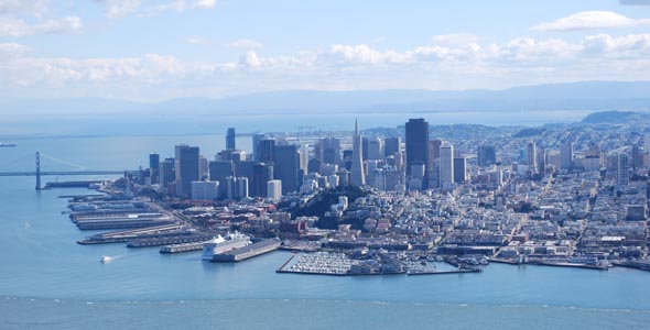
The Port of San Francisco covers 7.5 miles of San Francisco Bay shoreline, stretching from Hyde Street Pier in the north to India Basin in the south, with more than 1,000 acres under its jurisdiction.
