Nautical charts are a sailor’s roadmaps, but are much more detailed because of the requirements of navigation. Roadmaps may distinguish between freeways and dirt roads, but they don’t include information on the depth of the ruts or the height of overpasses.
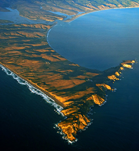
Drakes Bay is located Between Bolinas Bay and Tomales Bay west of Highway 1 in Marin County. Photo courtesy of OCSC Sailing
By CaptaIn Ray
Published: June, 2013
Nautical charts are a sailor’s roadmaps, but are much more detailed because of the requirements of navigation. Roadmaps may distinguish between freeways and dirt roads, but they don’t include information on the depth of the ruts or the height of overpasses. Charts, the result of centuries of experience and records, include depth markings, hazards to navigation, and notable on-land features to help the sailor establish the vessel’s position. Notations are now standardized, allowing sailors to reliably interpret the charts.
So, while studying a nautical chart of the Point Reyes/Drakes Bay area, I came across two objects that confused me. Both were shown with the symbol for a fixed or accurate position. One was labeled "BOB" and the other "CABESA." I’d never seen either of these terms on a chart and I had no idea what they represented.
My first thought was to look the terms up in Chart No. 1, the codebook for all symbols, abbreviations, and conventions used on U.S. charts. I was sure this hundred-page book would contain an explanation, but I was wrong. Chart No. 1 includes three pages dedicated to the "Nature of the Seabed," four pages each explaining "Tides and Currents," "Landmarks" and "Ports," and seven pages for "Lights," but no "BOB" or "CABESA."
My next step was to ask my co-workers. The ensuing discussion was interesting, fun, and (as is so often the case) wide-ranging, but of little help in unraveling this growing mystery. The best we could come up with was that:
1. "CABESA" might be a misspelling of cabeza, the Spanish word for head.
2. Sailing instructors often refer to the object (usually an empty juice container) tossed into the water to practice overboard rescues as "Bob" (because it bobs around), but it is highly unlikely that this type of Bob would be charted and it certainly would not be on the land!
I decided to visit these locations and see what is actually there. After a breakfast stop in Marin County, I arrived at the end of Sir Francis Drake Boulevard. The whales in the surf line of the Great Beach distracted me for awhile, but eventually I turned to my investigation of "CABESA." At the charted location, in an open, grassy field sloping down toward Drakes Bay, I found a solitary, vaguely head shaped rock. However, it was not visible from the sea and would not have been charted. Was this "CABESA"?
I then went to search for "BOB." The chart showed a side road leading down toward the beach. When I arrived at the turn-off, there was a sign that said "Authorized Vehicles Only." So I parked and walked down the road. After about 15 minutes, I was able to locate and identify another feature (a water tank) shown on the chart. It was just where the chart indicated it would be, so I felt well oriented. As I looked at where "BOB" should be, at first all I saw were sand dunes. Then I noticed the edge of a piece of concrete almost completely buried in the dunes. It turned out to be the foundation platform of a small building, perhaps 10x20 feet, but it was impossible to discern what the building had been or whether it was "BOB." I was zero for two in my investigation!
After returning home, I had an email conversation with the U.S. Coast Guard Waterways Management Department. They explained how much easier it is to get something placed on a chart than to have it removed. Those objects may have been on the chart for a very long time and it was unlikely that anyone today knew what "CABASA" or "BOB" meant. They thanked me for bringing these items to their attention, and assured me that both would be removed from the chart—no matter what they had once meant. Plus, I was encouraged to find and report "more charted objects that are not there."
Ray Wichmann, is a US SAILING-certified Ocean Passagemaking Instructor, a US SAILING Master Instructor Trainer, and a member of US SAILING’s National Faculty. He holds a 100-Ton Master’s License, was a charter skipper in Hawai’i for 15 years, and has sailed on both coasts of the United States, in Mexico, the Caribbean, and Greece. He is presently employed as the Master Instructor at OCSC Sailing in the Berkeley Marina.
