Nothing exemplifies the adage "the best things in life are free" like the San Francisco Bay Trail, the 330-mile path that offers endless outdoor joy to hikers, joggers, bikers, birders and anyone who loves meandering and discovering sights and scenes along our spectacular Bay shoreline.
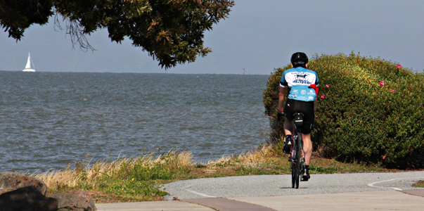
Photo by Wilfred J Jones
By Marjorie Blackwell
Published: June, 2013
Nothing exemplifies the adage "the best things in life are free" like the San Francisco Bay Trail, the 330-mile path that offers endless outdoor joy to hikers, joggers, bikers, birders and anyone who loves meandering and discovering sights and scenes along our spectacular Bay shoreline. From historic, natural and cultural interest points to sandy beaches, busy marinas, fishing piers, large cities and small towns, and more than 130 parks and wildlife preserves, the Bay Trail traverses the waterfront, offering closeup views of life in our multicultural region and the wonders of one of the world’s great estuaries.
Mile by mile and year by year, the Bay Trail is reaching its ultimate goal of encircling the entire Bay, extending 500 miles through all nine Bay Area counties. With a newly updated set of Bay Trail maps just issued, there is no time like the present to explore this recreational treasure. Since 2007, when the last Bay Trail maps were published, 60 miles of new trails have been completed, closing gaps and adding major new sections of paved, multi-use paths, dirt trails, bike lanes and sidewalks, with something new to explore in every county.
New Trail Sections
Among the newly completed sections are bike lanes in San Francisco on Illinois Street and a separated path on Cargo Way, which closed a gap in the BlueGreenway between 16th Street and Heron’s Head Park; the last piece of shoreline trail in South San Francisco, providing eight miles of continuous trail; 2.4 miles between Mountain View and Sunnyvale that opens up 26 miles of continuous trail between East Palo Alto and San Jose; a link at Oyster Bay Regional Shoreline in San Leandro that completes a 20-mile stretch between Oakland and Hayward; in Richmond, a lovely three-mile loop around a landfill and a one-mile connection to Wildcat Creek; a half-mile of new trail in the new Glen Cove Waterfront Park in Vallejo; four new miles of trail in American Canyon along the Napa River, including two miles of riverfront trail and a two-mile loop around the city’s former landfill; a new one-mile trail along the edge of the Sonoma Baylands wetlands; and bike lanes on East Road between Fort Baker and Sausalito.
Gaps to Fill
"We have about 170 miles of Bay Trail gaps left to complete," said Laura Thompson, Bay Trail project manager for the Association of Bay Area Governments (ABAG), "and each gap has a story of why it’s not finished." For example, on Paradise Drive in Tiburon and in several other places, there is a narrow road right-of-way with no room for a bike lane or sidewalk. Still, plans are afoot to close several gaps.
In some areas, a public utility has long-term plans that include the Bay Trail, such as the San Jose/Santa Clara Water Pollution Control Plant. At Skaggs Island in Sonoma County, a lengthy federal land transfer and restoration planning process will result in new Bay Trail segments, Thompson said.
Wetland restoration in the South Bay salt ponds in Union City and in other areas will include Bay Trail alignment, Thompson said, and planned developments, such as Bayview Hunter’s Point Naval Shipyard in San Francisco and Brooklyn Basin in Oakland, also will include trail alignments.
"In a number of areas," she added, "we have completed feasibility studies, but we don’t have funding for future phases such as design, environmental review and construction." These include the trail gap between Newark and Fremont, the Ravenswood trail gap in East Palo Alto, access to Alviso Marina County Park over the Guadalupe Slough in San Jose, and along Doolittle Drive in Oakland.
"The good news is new trail segments are under construction, including one on the new East Span of the Bay Bridge, between Oakland and Treasure Island, and the trail connection between the bridge and Emeryville. We’re also closing gaps in Richmond, as well as on Carquinez Scenic Drive in Contra Costa County, plus a segment in Hercules, and the Hamilton Bay Trail in Novato."
Favorite Trail Picks
The new and cleverly redesigned Bay Trail maps (see box) make it easier than ever to check out places to go. Just pick a card — any card — out of the map box, put it in your backpack and head out the door for a day of exploring the Bay Trail. Here are a few favorite places.
For views, Crissy Field in San Francisco will be a prime spot for watching the America’s Cup races this summer. From Fort Point under the Golden Gate Bridge, follow Marine Drive southeast along the water, passing the Warming Hut. A natural-surface trail hugs the shoreline through Crissy Field along the restored wetlands and sand dunes.
For outstanding bike rides, take the trail in Eastshore State Park from the Emeryville or Berkeley waterfront, ride past the Albany mudflats, along the Point Isabel Regional Shoreline in Richmond to Lucretia Edwards Park and the fascinating Rosie the Riveter World War II /Home Front National Historical Park. In Marin County, the Mill Valley-Sausalito path offers a lovely, smooth ride on a rail-to-trail conversion along Bothin Marsh, great for both bird- and people-watching.
For beautiful walks, visit the Glen Cove Waterfront Park in Vallejo, a tranquil 15-acre shoreline retreat with spectacular views of the Carquinez Strait. In Oakland, Middle Harbor Shoreline Park includes more than two miles of paved pathways encircling Middle Harbor Basin with marvelous views of the Bay, the Bay Bridge, tidal wetlands and maritime activity.
For kids of all ages, Coyote Point Recreation Area in San Mateo offers picnicking, swimming, windsurfing, bicycling, jogging, fishing, boating and sailing. Youngsters will love the giant, castle-and-dragon-themed Magic Mountain Playground.
For birding, the Bay Trail offers endless opportunities. The Palo Alto Baylands are a haven for Clapper Rails and other breeding, migrating and wintering marshland birds. Just to the south, the Shoreline at Mountain View, composed of Charleston Slough, former salt ponds and Shoreline Park and Lake, offers excellent year-round birding. Coyote Hills Regional Park in Fremont features a mix of woodland and marsh habitat, where you may see Marsh, Bewick’s and Rock wrens within a short distance. Wildlife viewing is part of the mission of the Las Gallinas Sanitary District wastewater treatment plant in San Rafael, where you will see a variety of ducks, Osprey, Golden Eagles, falcons and Great Horned Owls, as well as an occasional otter.
At the very southwest tip of the Bay Trail is Alviso, a 130-year-old town listed on the National Register of Historic Places and part of the city of San Jose. The quiet community is one of the last reminders of what Santa Clara Valley was like in the 19th century. Nearby are miles of levee trails abutting marshes, salt ponds, sloughs, freshwater creeks and Bay shallows. With some 250 species of resident and migratory birds, Alviso is home to the Don Edwards San Francisco Bay National Wildlife Refuge Environmental Education Center — run by the US Fish and Wildlife Service — which offers educational displays and information about wetland wildlife.
Wherever you go on the Bay Trail, say a quiet thank you to the California Legislature, which authorized ABAG in 1987 to develop a plan for "a ring around the Bay." In 1990, ABAG created the San Francisco Bay Trail Project as a nonprofit organization to plan, promote and advocate implementation of the trail. Today, a 28-member volunteer board of directors with a broad range of interests governs the project. The board meets twice a year and has a smaller steering committee that meets bimonthly to discuss program and planning issues. ABAG administers the Bay Trail Project, and it is funded in part by the Metropolitan Transportation Commission (MTC). Through statewide park bond funds, the State Coastal Conservancy has provided a significant amount of funding for planning and construction of Bay Trail throughout the region.
Put the Bay Trail in Your Pocket
ABAG has dealt the Bay Area a winning hand with its new Bay Trail map cards. The cleverly designed and updated Bay Trail map set consists of two dozen numbered map cards (4 x 7 inches each) tucked in a convenient, easy-to carry box, and a large fold-out map. The colorful map cards are the key to the Bay Trail, each zooming in on a detailed area of the system, with points of interest on the back. There’s even a separate card for birding the Bay Trail.
Bay Trail map sets are available for purchase at www.baytrail.org for $14.95, as well as at the Bay Crossings store at the San Francisco Ferry Building and in area bookstores. A companion online and mobile phone application is also available by visiting the website. The maps were funded in part by the State Coastal Conservancy.
For an outstanding bike ride with spectacular views of the City and Bay, take the Bay Trail from Richmond’s Marina Bay (pictured here) past the Albany mudflats and Point Isabel Regional Shoreline then along the Berkeley waterfront all the way to Eastshore State Park in Emeryville. Photo by Joel Williams

Maps designed by Lohnes & Wright
