The San Francisco Bay Area Water Trail sounds somewhat like an oxymoron since there is no path through the water, no trail markers, and the path has no start or end point.
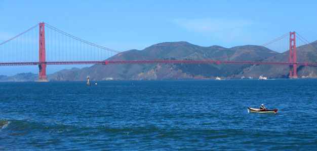
Photo by Galli Basson
By Marjorie Blackwell
Published: October, 2013
The San Francisco Bay Area Water Trail sounds somewhat like an oxymoron since there is no path through the water, no trail markers, and the path has no start or end point.
Yet, there is proof the Water Trail exists: it has a logo, a website — www.sfbaywatertrail.org —and a brochure. It is led by the State Coastal Conservancy working closely with the Association of Bay Area Governments (ABAG), and it’s engraved in law: the Water Trail Act passed by the California state Legislature in 2005.
The San Francisco Bay Area Water Trail also has hundreds of supporters: kayakers, windsurfers, dragon boat racers and canoe paddlers, who launch their boats and boards from sites all around the shoreline. They envision a linked network of new and improved launching and landing sites for non-motorized boats that will entice more people to experience the fun of being on the Bay, including overnight camping getaways. Water Trail supporters also seek to promote safe boating practices, reduce impacts on wildlife habitats and generate greater appreciation and stewardship of the Bay.
Although small boats and boards can be launched from dozens of beaches and piers around the Bay, the Water Trail, so far, has just four "designated" launch and landing sites. The Tidewater Boating Center on the Oakland Estuary is the first site to be designated as part of the network. This small, East Bay Regional Park District oasis, tucked away in an industrial area off of High Street, has a Park District office, a parking lot, picnic tables, restrooms, and a large floating dock with two gangways, one of which is fully accessible to disabled persons, a top priority for Water Trail launching sites. From here, boaters can paddle south to San Leandro Bay, a good spot to view birds and seals, or head north toward Jack London Square past working industrial areas and on out into the Bay.
Ayala Cove on Angel Island is a designated Water Trail site where boaters can pull their boats onto the beach or share dingy slips. The state park has picnic areas, restrooms, a visitors’ center, and an overnight camping area. In the South Bay, the Sailing Center in the Palo Alto Baylands Nature Preserve, a popular windsurfing site, has a pier where boaters can launch canoes, kayaks and windsurfing boards to explore the winding sloughs. And the Alviso Marina County Park at the southern tip of the Bay is the most recent designated Water Trail site, adjacent to salt ponds and marshes of the Don Edwards San Francisco Bay National Wildlife Refuge. From the park’s two boat launch ramps, there is a clear route through the salt marshes to the open waters of the Bay. The next place likely to become an official Water Trail site is Ferry Point Beach in Richmond. Don’t own a boat? No problem. The Water Trail’s website lists boating recreation programs by county, as well as numerous places to rent boats, join clubs and take classes.
In an effort to encourage and assist more Bay Area communities and nonprofit organizations to create or improve suitable launch and landing sites, ABAG is offering a total of $500,000 worth of grant funds from the Coastal Conservancy. (Information on applying for grants is available on the Water Trail website.)Water Trail signage and information at the launch sites about boater safety and wildlife stewardship are also in the works, and the Coastal Conservancy is developing a plan that outlines accessibility improvements for launch sites eligible for grant funds.
The idea of creating a Water Trail began over a decade ago when Bay Access, a local kayakers club, set out to do something to save boat launch sites around the Bay that were fast disappearing due to development. According to Bay Access President Penny Wells, "We decided to pursue state legislation, and the Water Trail Act passed with flying colors in 2005." The Bay Conservation and Development Commission (BCDC) then stepped up to develop the Bay Water Trail Plan in 2007. The Coastal Conservancy certified the plan’s Environmental Impact Report in 2011 and awarded ABAG a $1 million grant to help implement the plan.
Wells and other Water Trail supporters dream of having places all around the Bay where boaters can camp overnight, such as at Point Pinole in Richmond, or stay in a nearby waterfront hotel, such as in downtown Petaluma.
"The Bay is our largest open space," notes Galli Basson, ABAG’s Water Trail planner. "And we have such a diversity of habitats – urban, natural, marshy wetlands, sandy beaches and rivers. There’s something for everyone on the Bay, from exciting experiences to quiet and peaceful ones. People travel long distances to visit places that they can experience right here on the Bay."
The Water Trail joins two other regional trail systems in progress: the San Francisco Bay Trail, which will ring the 500-mile shoreline around the Bay, and the Bay Area Ridge Trail, a 550-mile trail along ridgelines overlooking the Bay. "The Water Trail will greatly increase opportunities for Bay Area residents to enjoy the beauty and wonders of our region," said Project Manager Ann Buell of the Coastal Conservancy.
The Bay Area Water Trail brochure can be downloaded at www.sfbaywatertrail.org
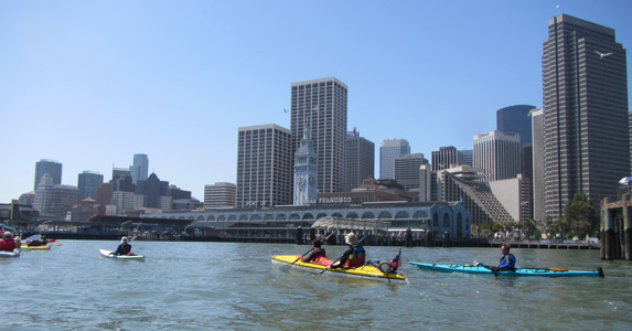
Kayakers celebrating San Francisco’s Maritime Day on the water in front of the Ferry Building. Photo by Galli Basson
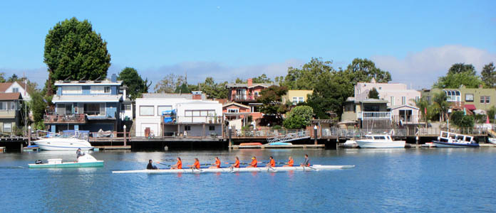
Rowers practicing in the Oakland Estuary near Tidewater Boating Center. Photo by Galli Basson
