For a weekend sail out the Gate, there are two destinations you can reach in daylight, spend the night and sail home the next day.
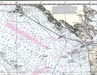
Captain Ray’s chart showing the path he took to Drakes Bay this March.
By Captain Ray
Published: June, 2014
For a weekend sail out the Gate, there are two destinations you can reach in daylight, spend the night and sail home the next day. One is to the north and one to the south. This month, I’d like to tell you about the trip north, to Drakes Bay.
Drakes Bay is located about 15 miles north and 20 miles west of the Golden Gate. It is the bay formed by Pt. Reyes and it makes up part of the Gulf of the Farallones National Marine Sanctuary. To quote the note on the nautical chart: “National Marine Sanctuaries are protected areas, administrated by NOAA [the National Oceanic and Atmospheric Administration] which contain abundant and diverse natural resources such as mammals, seabirds, fishes, and tidepool invertebrates. These areas are particularly sensitive to environmental damage such as spills of oil and other hazardous materials, discharges, and groundings.”
Getting to Drakes Bay can often be a very rousing upwind sail from the Gate. However, the weather during my last trip, this past March, was quite benign. In order to take advantage of the ebb (outflowing) current at the Gate, we departed Berkeley about 0700. The current was due to change at 0930, and we wanted to be well beyond the reach of the flood (inflowing) as it strengthened.
We transited Bonita Channel, between the Potato Patch, a shoal area just outside and north of the Gate, and the Marin Headlands. While not always passable, when it is, this channel reduces the travel time by about an hour. By late morning, we were abeam Buoy “1DR” off Bolinas. The wind remained light, but no one complained.
The day was beautiful, the seas gentle and the highlight of our trip was sighting whales. We didn’t get the great aerial displays that humpbacks often enthrall us with, just the blows and backs of California greys. Still, when you consider that we hunted them almost to extinction, it is a great pleasure each time we are graced with a sighting. Approximately 15 more miles to the northwest from “1DR” and the entrance buoy to Drakes Bay was in sight. By mid-afternoon we were securely anchored and being serenaded by the barking sea elephants on the beach.
Once all our gear was stowed and the kettle on, we settled in the cockpit and I told my crew that this is the same bay that (the not-yet Sir) Francis Drake anchored in June 1579. (He wasn’t knighted until he returned to England.) Yes, that is correct; 40 years before the Mayflower, the English were in California! Drake had sailed around Cape Horn (the southern tip of South America) and was the first English ship in the Pacific Ocean. He pillaged and plundered Spanish settlements on his way north, and when he reached California he had a ship full of Spanish gold and silver. He also had a ship that was leaking and sorely in need of a refit.
While some suggest that the location of this refit is a controversy, Drake himself tells us where it was—at latitude 38.0° north and described as “a faire and good bay... with white bancks and cliffes, which lie toward the sea.” As we sat in the cockpit gazing at the white cliffs with the GPS reading 38.0° north latitude, there seemed little doubt that this was the place Drake took refuge while making the very necessary repairs to his boat.
If you want to read more about Drake’s sojourn in California, I recommend Lost Harbor: The Controversy Over Drake’s California Anchorage, by Warren L. Hanna.
Ray Wichmann, is a US SAILING-certified Ocean Passagemaking Instructor, a US SAILING Master Instructor Trainer, and a member of US SAILING’s National Faculty. He holds a 100-Ton Master’s License, was a charter skipper in Hawai’i for 15 years, and has sailed on both coasts of the United States, in Mexico, the Caribbean, and Greece. He is presently employed as the Master Instructor at OCSC Sailing in the Berkeley Marina.
