A small remote-controlled boat, mounted with an innovative camera, has recently been cruising with Baykeeper's pollution patrol boat along the San Francisco Bay shore.
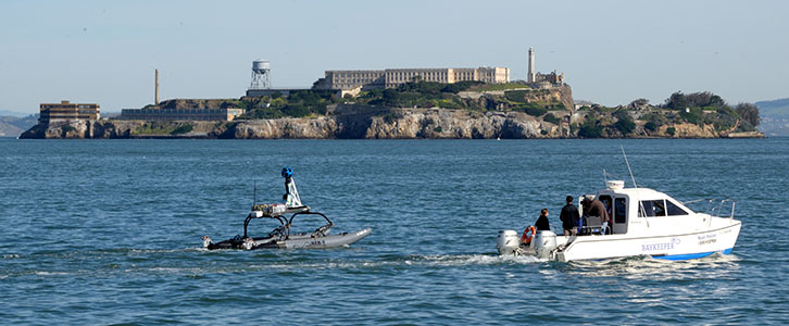
Baykeeper is using a remote-controlled boat (left), mounted with a special camera and operated from the Baykeeper pollution patrol boat (right), to photograph the entire San Francisco Bay shoreline from the water. They’ll use the photos to create a new tool to help protect the Bay from sea level rise caused by global climate change. Photo by Robb Most
By Sejal Choksi-Chugh
Published: April, 2015
A small remote-controlled boat, mounted with an innovative camera, has recently been cruising with Baykeeper’s pollution patrol boat along the San Francisco Bay shore. We’re creating a new tool to help protect the Bay from sea level rise—the San Francisco Bay Shore View Project.
As global climate change causes sea levels to rise, San Francisco Bay’s shorelines are at greater risk of flooding. And as water levels reach more pollution sources—such as sewage treatment plants, industrial facilities and landfills—contamination will be a growing threat to the Bay. But exactly where will flooding occur? And where will pollution hotspots emerge? It will be easier for everyone to answer these questions with a view from the water.
That’s where the little remote-controlled boat comes in. It’s designed to keep the Google Trekker camera mounted on its top steady in the Bay’s waves. With support from Google, Baykeeper is photographing the entire San Francisco Bay shoreline from the water. We’ll use the photos to create the San Francisco Bay Shore View, a complete set of “Street View” images of the Bay shoreline. The public will have free online access to the images later this year, along with added information about the shoreline’s vulnerability to rising water levels.
The San Francisco Bay Shore View images will allow residents of Bay Area communities to answer questions such as:
What parts of my shoreline community are likely to be flooded as sea levels rise?
Will pollution levels near my home, school or park increase due to rising tides?
Is a newly proposed shoreline development project likely to be flooded in the next 50 years?
The Shore View images will also show where the Bay’s wetlands are at risk. Wetlands are crucial to the Bay’s health. They provide habitat for wildlife, filter pollutants and protect shorelines from flooding. These marshy areas depend on the tides; they need time both underwater and above water for part of each 24-hour cycle. Tens of thousands of acres of Bay wetlands have been restored in recent decades, some as a direct result of Baykeeper litigation, but they could be flooded as sea levels rise, keeping them underwater 24 hours a day.
Baykeeper will use the Shore View Project in our work to defend San Francisco Bay from pollution. Bay Area residents, city planners and community organizations will also be able to use this tool to advocate against unwise shoreline development. Moreover, all Bay Area shoreline communities will increasingly grapple with the tough questions about how to adapt to sea level rise. We hope our Shore View Project will help local leaders craft sustainable solutions to protect their communities, San Francisco Bay and the Bay’s wildlife in the years ahead.
Sejal Choksi-Chugh is the Program Director and Interim Executive Director of San Francisco Baykeeper, www.baykeeper.org. Baykeeper uses on-the-water patrols of San Francisco Bay, science, advocacy and the courts to stop Bay pollution. To report pollution, call Baykeeper’s hotline at 1-800-KEEP-BAY, e-mail hotline@baykeeper.org, or click “Report Pollution” at www.baykeeper.org.
