Over the last two issues, we have explored the colorful history and recent activity at Richmond's Point Molate.
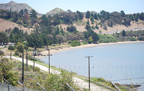
Point Molate Beach Park is located just north of the Richmond-San Rafael Bridge on Stenmark Drive and consists of slightly over 11 acres of parkland along a 1/3-mile stretch of shoreline. Photo by Joel Williams
By BC Staff
Published: September, 2015
Over the last two issues, we have explored the colorful history and recent activity at Richmond’s Point Molate. In this last installment of the series, we will explore what the future could hold for this 413-acre waterfront site with 1.4 miles of unobstructed shoreline just north of the Richmond-San Rafael Bridge.
Point Molate’s historic buildings, waterfront location, unobstructed Bay views, expansive open space and recreational opportunities make it an ideal site for development. That being said, the costs and management challenges of converting the former military site to other uses are significant.
The San Pablo Peninsula, where Point Molate is located, is zoned for community and recreational uses, with the exception of marine or light industrial uses for Terminal 4 and Chevron’s Point Orient. The majority of property remains vacant, except for Building 123, but efforts to remediate and restore the site continue.
The Point Molate Community Advisory Committee (PMCAC) was formed in 2011 to work with the Richmond City Council, citizen advisory boards and commissions to provide oversight on Point Molate matters. The committee’s work has included advising the city council on environmental remediation, land use planning and financial management.
Among other things, intensive industrial use over the last half-century by the U.S. Navy resulted in extensive environmental contamination of the groundwater and soil at Point Molate. The City of Richmond oversees cleanup efforts at Point Molate with advisory assistance from the PMCAC.
Shoreline
Point Molate Beach Park is located just north of the Richmond-San Rafael Bridge on Stenmark Drive and consists of slightly over 11 acres of parkland along a 1/3-mile stretch of the site’s shoreline. The park originally opened to the public in the mid-1970s as a popular recreational destination until its closing in 2003.
The park reopened in October 2013 after volunteers led by Citizens for a Sustainable Point Molate restored the beach and the City of Richmond invested $115,000 for park improvements and upgrades. The city has maintained the park since 2013. However, the beach is experiencing significant shoreline erosion, with accelerated losses in the past two years of over one foot of bluff line. A combination of storm-driven and seasonal tides along with waking from the Vallejo ferry has scalloped the shoreline from Point Molate Beach Park to Point Orient.
Another distinctive feature of the shoreline is the 1,450-foot pier that extends into San Francisco Bay at a depth of 18 feet. The pier was built in 1942 and has been periodically restored.
Bay Trail
There have been discussions with the San Francisco Bay Trail Project about pedestrian and bicycle accessibility, and about linking the Bay Trail around Point Molate along the shoreline area. A 50-foot-wide railroad right-of-way crosses the property along the shoreline and continues north around the Point San Pablo Peninsula. The Southern Pacific rail line is no longer in use and is in disrepair.
As part of the I-580 Access Improvement Project, the shoulder on the eastbound I-580 exit lane will be converted to a third travel lane. The project will upgrade the current bicycle access to Point Molate and the shoreline with a separate bicycle-pedestrian path on the north side of I-580 adjacent to westbound traffic. The project is expected to be completed in 2018. Additionally, in 2014, Chevron donated a 0.9-mile easement to East Bay Regional Park District to continue the Bay Trail from the Richmond-San Rafael Bridge along the shoreline to Point Molate Beach Park.
Infrastructure
Point Molate’s crumbling infrastructure is insufficient at the present time to support any new development or build-out. A general overview of the current state of the system:
• All water is supplied by East Bay Municipal Utility District (EBMUD) through one 12-inch water main along Stenmark Drive from the Potrero and Richmond reservoirs. The water pumping and distribution system is inadequate to meet the capacity needs of a large build-out or development and would require substantial repair and upgrading.
• Power is a significant problem. The power plant servicing Point Molate is broken down, power lines are disabled and the transformers are dated. Any new development would require substantial new power infrastructure.
• Currently, there is no collection system for sewage. A sewage treatment plant for the Naval Fuel Depot was later replaced by a smaller, portable treatment plant that now treats groundwater. The current system is inadequate to serve large-scale development. Furthermore, it would be a massive undertaking to build a collection system to connect the property to the sewage treatment plant at Point Richmond.
A Navy assessment in 1999 estimated infrastructure replacement costs at $18 million. In the intervening years as the property has remained vacant, homeless encampments appeared and vandals stripped the plumbing and copper wiring in the Winehaven winery, winemaster’s residence, Building 6 and the cottages in that area. The property’s crumbling infrastructure and associated costs could serve as significant deterrents to marketing and developing the property.
Access
Another major barrier to developing Point Molate is poor vehicular access. Stenmark Drive, located between I-580 and Terminal 4, provides the only public access to Point Molate. This two-lane road lacks sidewalks and lighting and is only accessible to westbound I-580 traffic from the Western Drive/Point Molate exit. There is no direct access from eastbound I-580.
Drivers travelling eastbound on I-580 must take the exit past the toll gate, cross under the freeway, get back on I-580 and continue west to the Stenmark Drive/Point Molate exit. The City of Richmond owns and maintains a 40-foot-wide right-of-way adjacent to the road. Secondary roads throughout the site are narrow and steep, full of potholes and poorly maintained.
Attempts to broaden or modify Stenmark Drive would be difficult, if not impossible. Chevron property abuts Stenmark Drive and the underlying infrastructure of the Richmond-San Rafael Bridge makes widening the road financially and structurally prohibitive. There is no public transit, designated bicycle lanes nor pedestrian paths linking Point Molate to surrounding areas.
Funding
One of the greatest constraints on redeveloping Point Molate is the lack of capital or a dedicated funding source. The City of Richmond’s financial capabilities are limited, and a military base reuse project—traditionally administered through a redevelopment agency and funded through tax increment financing—is no longer a viable option.
Securing funding for infrastructure and historic preservation, as well as ensuring financial sustainability, will ultimately determine the success of Point Molate. The site needs a management structure that will address these funding needs and help guide future implementation decisions. A number of management options for Point Molate have been proposed over the years, each with its own benefits and limitations. Those options include:
1. Private Developer Acquires All or Part of Point Molate
The City of Richmond has traditionally pursued development projects through a master developer or developer to lease or purchase the property and could follow a similar strategy for Point Molate. Under this model, the city seeks a developer to develop all or part of the site.
2. Chevron Purchases Point Molate
In 2004, Chevron submitted a proposal to purchase Point Molate for $80 million and convert it to open space with some light industrial and commercial use. The proposal included $1 million per year to the city for 25 years for site maintenance. Given that Chevron has coveted Point Molate as a security buffer, the company assumedly maintains interest in purchasing the property and may submit a similar proposal.
3. Point Molate Left Undeveloped as Open Space and Park Lands
Given the city’s financial constraints, this model assumes Richmond would partner with East Bay Regional Park District or some other public or nonprofit entity in developing and preserving open space and parkland. The property could be transferred under a Public Benefit Conveyance. This model would require a partner with experience in developing and leasing historic assets and would most likely involve a collaboration with a land trust or conservancy as a primary fundraising partner to ensure financial sustainability.
4. Management Entity Oversees Point Molate Redevelopment
Under this model, a management entity (such as a trust, public/private partnership, agency or nonprofit corporation) would oversee the marketing and management of Point Molate. The entity would be structured similarly to a nonprofit organization, where proceeds from the property are reinvested back into the development and maintenance of the site. Primary responsibilities would include real estate development and leasing of existing assets, and to a lesser extent environmental remediation, planning, community engagement, advocacy and partnership development. This model assumes partnership with a conservancy or land trust that would provide fundraising support.
Whether Point Molate is successfully developed will ultimately also depend on the ability to build a solid, sustainable financial foundation, one that will support the restoration, rehabilitation, conservation and redevelopment of the site. Furthermore, any capital investment would need to be independent of City of Richmond funding. A management entity, independent of but accountable to the city, could oversee that effort while maintaining all or some of the site for public use.
Funding to support the redevelopment of Point Molate could be generated through land sales, a partnership with a fundraising organization or through other funding sources. Like at the Presidio, leasing revenue from commercial and residential space at Point Molate could be reinvested back into restoring the site and its structures. The establishment of a management entity for Point Molate places the City of Richmond in the best position to proceed with the redevelopment of the property and its transformation into a first-class regional waterfront recreational resource.
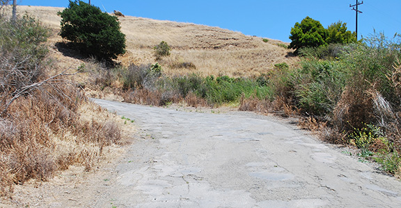
One major barrier to developing Point Molate is the poor conditions of the roads that have been poorly maintained over the years. Photo by Joel Williams
