Our New York tri-state area brethren are grappling with many of the same issues we are when it comes to how to make the most and best of the new waterfront lifestyle. Here, Neal Kronley and Carter Craft of the Metropolitan Waterfront Alliance weigh in on waterfront highways.
By Neal Kronley and Carter Craft
Published: November, 2002
As the baseball playoffs begin, we here at Waterwire recall that fateful World Series in October 1989 when an earthquake disrupted play and brought down the Embarcadero Expressway in San Francisco. One unlikely result of this tragedy was the formation of a new waterfront park and promenade easily accessible to the city’s downtown and surrounding neighborhoods. Long before this tumultuous event, neighborhoods, planners, policy makers, and a myriad of other parties were already awakening to the negative consequences of building waterfront highways.
It would be an injustice to write this article without at least one mention of the man responsible for encouraging a culture of infrastructure building and improvements centered on the automobile. Robert Moses—both the tyrannical and the heroic—believed that drivers should enjoy a pleasant view during car outings and lined the waterfront with highways for their benefit. There’s a great irony here that Moses never drove himself anywhere, and yet the legacy of this policy continues to be the isolation of countless citizens—locally, nationally, and internationally—from their waterfront.
Neighborhood activists, citizens seeking new parks and renewed waterfront access, and advocates for transportation alternatives consistently agree on the need to closely examine highway developments and improvements. Some victories have been made in the New York and New Jersey region, but the course remains an uphill struggle.
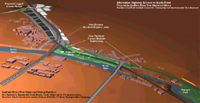
Among the mad looping highways of the Bronx, the Sheridan is not the most widely traveled. Only 2 miles long, the expressway travels along the Bronx River to connect the Cross Bronx and Bruckner Expressways. The development of nearby Hunts Point as an industrial center has resulted in an increase of truck traffic in this Bronx neighborhood. Responding to this situation, NYS DOT has proposed a new exit from the Sheridan that would increase traffic and, to many in the neighborhood, forever isolate this neighborhood from its waterfront. Joan Byron, an architect with the Pratt Institute for Community and Environmental Development, is working with a broad coalition of neighborhood groups in the South Bronx to stop the proposed development. Ms. Byron stated that “After 50 years of the Interstate Highway System, we have to question if it makes sense.”
As an alternative to the NYS DOT proposal, a number of organizations that comprise the Southern Bronx River Watershed Alliance—Nos Quedamos, The Point, Sustainable South Bronx, Youth Ministries for Peace and Justice, The New York City Environmental Justice Alliance, Tri -State Transportation Campaign, and PICCED—have proposed closing the Sheridan to vehicular traffic and developing a 28-acre waterfront park. Although this park would complement the exciting projects already underway on the Bronx River, the Governor’s office has refused to direct NYS DOT to study the community plan. The community groups hope to make progress at a neighborhood meeting with state officials on October 10.
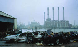
Like many highways in our region, New Jersey’s Route 21 abuts a riverfront, the Passaic River. Recent developments on the New Jersey side of the Hudson River have been both innovative and encouraging for residents, visitors, and urbanists alike: a new state park is being created in Newark, light rail transit projects are enhancing linkages between communities, and the renowned NJ Performing Arts Center has struck a new cultural tone for Newark. Despite these forward thinking actions, NJ DOT is currently going forward with plans to expand the highway closer to the waterfront—a move that will further distance local communities from their waterfront. NJ DOT’s response to the need for improved waterfront access is to build an access plaza over the highway, a move that leaves activists such as Janine Bauer of the Tri-State Transportation Campaign unfulfilled. Ms. Bauer believes that “NJ DOT sees the waterfront as a traffic corridor.” A claim that is difficult to refute given the agency’s current development plans. Such planning is distant from the careful work of planners and architects to enhance the rich culture of Newark’s “Ironbound Community” by providing better access to the waterfront next to busy Raymond Avenue.
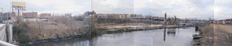
Later this month, the NYC Parks Department will officially open a new park between 135th and 139th Streets along the Harlem River in Manhattan. This new parkland is the first phase of the Harlem River Park, a much desired waterfront promenade not unlike those in Brooklyn Heights or Hoboken, New Jersey, which will eventually extend to 145th Street.
Building a park between the waterfront and the bustling Harlem River Drive comes with a number of concerns for residents and community activists: protective fencing must dissuade people from entering the highway but encourage people to use the park, access to the water itself must be developed, and “amenities” such as restrooms should be provided if residents are to fully utilize the space. Complementing these arduous but navigable boundaries, the NYC DOT plans to rebuild or improve the condition of all of the Harlem River bridges and use a stretch of riverfront between 131st and 123rd Streets as a staging area. NYC DOT will give the staging area to the Parks Department after the completion of its construction projects, but this will not occur until 2012. Tom Lunke, Director of Planning for the Harlem CDC, explains the park’s predicament, “NYC DOT wants no public access through the staging area although there are different stages of construction.” Mr. Lunke hopes a compromise will be made that allows the public to use the riverfront safely during the construction process. As MWA has pointed out in numerous meetings, construction of the Hudson River Park/Route 9A project did include an interim pathway that was installed beside the staging area and allowed for continuous access. “What worked in the Village would work in Harlem, too,” says MWA’s Carter Craft.
The NY/NJ region is linked by the waterfront yet many people fail to notice the beauty and open spaces along those corridors because they are zooming past or over on highway. As the preceding examples indicate, there is an entrenched culture of building and expanding expressways, highways, and parkways next to the waterfront. Although it is unlikely that we will part with highways and automobiles in the near future, a dramatic shift in policy is not entirely unlikely. The NY/NJ region has the capacity for and a cultural disposition towards the use of more mass transit. MWA encourages local community groups to advocate for smart uses of the regions waterfront for pedestrian, bicycle, and waterborne transit