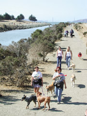
You may be among the hundreds of thousands of Bay Area residents who cross over or under San Francisco Bay every day, but how often do you think of going around it? Thanks to a visionary project begun more than a decade ago, walkers and bicyclists can now explore 230 miles of Bay shoreline.
Published: December, 2002
You may be among the hundreds of thousands of Bay Area residents who cross over or under San Francisco Bay every day, but how often do you think of going around it?
Thanks to a visionary project begun more than a decade ago, walkers and bicyclists can now explore 230 miles of Bay shoreline and enjoy the tremendous variety of human activities and wildlife that the Bay supports, from marinas, fishing piers, seaports, and parks to habitat for oysters, sea lions, pelicans, peregrine falcons, and hundreds of other species. The Bay Trail, when completed in the next decade, will extend more than 400 miles around the region’s most valuable natural asset, linking the 9 Bay Area counties and 47 cities.
The Bay Trail is a discovery route that travels through cities and towns, past historic and cultural points, along beaches and into remote natural areas. The Bay Trail network consists of a continuous main path (the "spine") as well as spurs that lead to points of interest close to the shoreline and inland connectors leading to commercial and residential areas. In San Mateo County, the trail meanders for 17 miles from Coyote Point Park to Redwood Shores, while across the Bay, it runs a straight 9 miles along the edge of the shoreline from the San Leandro Marina to Hayward Regional Shoreline. From San Francisco’s Fisherman’s Wharf, it stretches 20 miles across the Golden Gate Bridge to Sausalito and all the way to Tiburon. Depending on locale and terrain, the trail consists of paved paths, dirt trails, bike lanes, sidewalks, or signed bike routes.
In addition to offering refreshing, recreational, and get-away-from-it-all opportunities for nearly 3 million people who live within 2 miles of the route, the Bay Trail serves as a commuter path for bicyclists and pedestrians who can connect to residential neighborhoods, schools and colleges, commercial and industrial areas, and, most importantly, to public transit. The trail is within 2 miles of 23 Caltrain, 22 BART, and 19 VTA stations; 5 Muni Metro, 6 Amtrak, and 2 ACE stations; hundreds of bus stops; and all 10 Bay Area ferry terminals.
Trail segments are built and maintained by local, regional, state and federal agencies, and special districts, in partnership with citizens’ organizations, business, and industry. The Bay Trail is administered by a nonprofit organization housed in ABAG that coordinates its development. Administrative costs of the Bay Trail Project are shared by ABAG and MTC, with MTC’s $140,000 annual portion provided through toll bridge revenues.
When the plan to develop the Bay Trail was adopted in 1989, 170 miles of it already existed, due largely to persistent efforts of the San Francisco Bay Conservation and Development Commission (BCDC) to provide public access to the waterfront. It took a few years to build awareness and momentum, but now, according to Bay Trail Project Director Janet McBride, "Piece by piece, the Bay Trail is coming together."
Private developers are often urged to incorporate public access and construct trail segments as part of new development near the bay. Seismic retrofit projects of three Bay bridges—the Benicia/Martinez, Carquinez, and the new eastern span of the Bay Bridge—include bicycle/pedestrian paths. (Currently, the Golden Gate and Dumbarton bridges are the only two Bay crossings that have bicycle/pedestrian paths.)
Over the past few years, MTC has allocated nearly $2 million in federal transportation funds to Bay Trail projects. State grants to local communities to construct Bay Trail sections also have increased in recent years. "In 2000," McBride said, "$7.5 million from the Proposition 12 park and open space bond was allocated for new Bay Trail development."
Military base reuse has provided opportunities to create more access to the Bay. The closings of Skaggs Island Naval Reservation in Sonoma County, Hamilton Field in Novato, Mare Island Naval Shipyard in Vallejo, the Alameda Naval Air Station, the Oakland Army Base, and the Presidio Army Base and Hunters Point Naval Shipyard in San Francisco have all opened the door for improving shoreline Bay Trail alignment.
Although the trail is more than halfway developed, McBride pointed out that the easiest sections have been built, and the more difficult areas remain. The obstacles include industrial operations such as airports and salt harvesting, hazardous or toxic clean-up areas, private property, sensitive habitat, and roadways unsafe for bicycles or pedestrians. Trail development in some areas may depend on long-term roadway improvements, such as the possible widening of Highway 37 in the North Bay.
While it may be another decade before anyone can circle the entire Bay on foot or by bicycle, opportunities abound now to head down to the waterfront and take in the beauty of the region’s shimmering estuary and the graceful hills surrounding it.
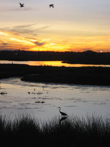
Standing on the shoreline, you can visualize how concepts of the Bay have changed from the days when sailing ships and ferryboats plied from shore to shore, to an inglorious era of its use as a dumping ground for fill, to our recognition today of the Bay’s inestimable value and the need to restore its natural contours and wetlands, and to increase public access. The desire to get close to the water is instinctual. The Bay Trail offers a splendid way to celebrate the water’s edge. After all, if it were not for San Francisco Bay, we would be just another area.
San Francisco to Marin County Ferry Loop
A spectacular 20-mile bike ride from Pier 41 in San Francisco to downtown Tiburon. The route follows city streets to Fort Mason, along the Crissy Field shoreline promenade, across the Golden Gate Bridge, through Sausalito and Mill Valley to Tiburon, where you can catch a ferry and relax on a 30-minute ride back to San Francisco. Or take a shorter, 8-mile route from Pier 41 to Sausalito and return on the ferry.
An easy 1-mile route for walking, bicycling, or rollerblading that offers views of San Francisco International Airport and its runways from a shoreline pathway along the edge of hotels in Millbrae and Burlingame. A great place for kids to learn to bicycle or rollerblade.
Palo Alto Baylands to Mountain View Shoreline Park
Along this 14-mile route, hikers and bicyclists can enjoy shorebird viewing in the Palo Alto Baylands at the Lucy Evans Interpretive Center and public art sculptures at Byxbee Park, stopping off at the historic Rengstorff House and the Stevens Creek Shoreline Nature Study Area in Mountain View Shoreline Park.
Sunnyvale Baylands Park
Great bird-watching for hikers and bicyclists on this 7-mile trip that follows a gravel levee trail around the Open Water Bird Preserve and passes by the Sunnyvale Environmental Center on the way to Baylands Park. Continue on the levee loop spur trail for an additional 4.5-mile trek.
San Leandro Marina to Hayward Regional Shoreline
Hike or bicycle through a mosaic of landscapes including mud flats, salt marshes, and grasslands along 7 miles of levee trails through the 1,800-acre Hayward Regional Shoreline, rich in history, views, and wildlife. Easy trip.
Martin Luther King, Jr. Regional Shoreline
Garretson Point to Arrowhead Marsh
Nestled in San Leandro Bay, Arrowhead Marsh is a hidden jewel providing critical habitat for shorebirds and an oasis for trail enthusiasts. The 4-mile route is highlighted by a wooden boardwalk extending into the marshland with a viewing platform on Arrowhead Point (named for its shape as viewed from the air). The park features the "Whale Garden" playground and an expansive lawn and picnic area.
Bay Farm Island Loop Trail
Walkers, skaters, runners, and bicyclists love this Bay Trail loop for its smooth paved path, convenient location, and picture-perfect views of natural and urban wonders. The trail loops around the perimeter of the island, passing by a ferry terminal, Bay wetlands, a golf course, and a model airplane park. To extend the 6-mile route, cross the bicycle drawbridge and follow the trail through the Elsie Roemer Bird Sanctuary to Robert Crown Memorial Beach.
Albany Bulb to Richmond Marina Bay
Enjoy spectacular views of the San Francisco skyline, as well as great people- and bird-watching along this popular recreational stretch. Check out the Rosie-the-Riveter Memorial sculpture in Marina Bay Park, and detour to the Albany Bulb to view constantly changing murals and found-object sculptures. Easy 11-mile trip trip for hiking, rollerblading, and bicycling.
Benicia Marina to the Benicia State Recreation Area
This moderately difficult 12-mile route boasts rich history, views across Carquinez Strait, and cool breezes on a hot day for hikers and bicyclists. It takes you from the marina to Point Benicia, through historic downtown Benicia, past the old State Capitol, to the State Recreation Area.
Tolay Creek Trail
This 9-mile segment follows Tolay Creek in the San Pablo Bay National Wildlife Refuge from Highway 37 to Lower Tubbs Island and Midshipman Point. Follow the levee trail along tidal marshes for exceptional shorebird and waterfowl viewing. The trail is closed to dogs and horses.
For complete descriptions and information, check the Bay Trail Web site: http://www.baytrail.org
(Route length is stated as round-trip miles)