Richmond has traditionally been a water-oriented, railroad community with a big oil refinery. Is it the next “hot spot” for waterside development, including casinos and even ferries?
Published: February, 2005
Richmond has traditionally been a water-oriented, railroad community with a big oil refinery. Its first maritime facility, Ellis Landing, was established in 1860 at the foot of what is now Harbour Way. That is the same location as the terminal for the Richmond ferry that operated for a short period after the 1989 Loma Prieta Earthquake. It is also adjacent to the Port of Richmond’s operating container terminal and is on the
opposite side of Harbour Way from the old Ford Assembly Building, which is about to be rehabilitated and transformed into a commercial center. Ellis Landing operated for more than 40 years until the beginning of the 20th century, with sailing scows carrying farm produce to the City (San Francisco) and ferrying passengers back and forth across the Bay, but only when the tide was high enough to navigate through the mudflats. Ellis Landing was eventually sold to the city.
Toward the end of that century, in 1895, one of Richmond’s founding fathers, Augustin Macdonald, in an ill-fated duck-hunting expedition, first viewed the western shore of what was then an island, Point Richmond. He was impressed not only with the beauty of the shoreline but with its deep water, and learned that the shoreline of Point Richmond was “the only point on the east side of the Bay where land and navigable deep water meet.” He used that information to promote Point Richmond as the western terminus of both the Southern Pacific and Santa Fe railroads. Santa Fe accepted, and on one of Richmond’s most memorable days, July 3, 1900, the ferry “Ocean Wave” discharged the first passengers at Point Richmond’s Ferry Point to a waiting Chicago-bound train. Later that same day, the first Santa Fe train pulled in from Chicago and transferred its passengers to the ferry for San Francisco. Point Richmond had become the western terminus of the continental railroad.
Over the years, Ferry Point became a very busy terminal, not only for ferry-to-rail passengers, but also for railroad cars that were transferred to barges for the trip to San Francisco. In recent years, operations declined as passengers shifted from rail to air and as ports and railroads shifted to containerized cargo, with the Port of Oakland becoming the predominant container port of the Bay Area. Eventually, Santa Fe abandoned operations at Ferry Point, and the terminal has since become a part of the Regional Park System.
Available Land Attracts Developers
Today, as the Bay Area’s population continues to surge and close-in land has become ever scarcer, both residential and commercial developers have been attracted by the availability of land in Richmond, both for residential and commercial developments. So, Richmond has attracted an increasing number of developers, especially for projects along the south shore, around Marina Bay where Henry Kaiser’s World War II shipyards once operated.
Taken together, these developments can be expected to translate into a growing demand for transportation facilities, including a San Francisco-bound ferry service. Such a service was tried immediately after the 1989 Loma Prieta Earthquake, which knocked out a key section of the east span of the Bay Bridge. According to Architect Tom Butt, a member of the Richmond City Council, “We always thought that the potential was there for a ferry service to San Francisco. But it is going to take the right equipment, the right location, and the right schedule to make a ferry system work.”
The site that was chosen for the 1989 ferry service and remains earmarked for future ferry service is the site of Ellis Landing, which is located on city-owned land at the foot of Harbour Way, opposite the Ford Assembly Building and adjacent to the port’s container terminal. Only a short distance from an area of growing residential and commercial development, it is the only site along the ship channel with an essential ingredient, adequate parking. According to Tom Butt, the 1989 post-earthquake ferry service from there would have worked except that “they gave us the slowest, clunkiest ferry they had.” Will Travis, head of the Bay Conservation & Development Commission, concurs and termed it “a ratty old ferry!”
Since 1989, more business parks and residential developments have been built in and around the adjacent Marina Bay area on Richmond’s south shore. Those developments are undoubtedly a factor in the city’s recent population growth at a rate of some 1,000 persons annually, reaching an estimated 101,370 residents in 2003.
Another development about to take place along the south shore is the rehabilitation of the 517,000-square-foot Ford Assembly Plant, located at the foot of Harbour Way with ship-docking facilities directly on the channel leading to Marina Bay. Built in 1931, the Ford Building was severely damaged during the 1989 Loma Prieta Earthquake, but the city was able to secure sufficient funds from the Federal government to seismically strengthen the structure. Now, the building has been turned over to Orton Development, Inc. for renovation into a center for commercial and retail tenants. The Orton firm has said that it will build a “working wharf” that may eventually “include ferry service to bring consumers from across the Bay.” A member of the city council fancies the transformation into “a Jack London Square or a Fisherman’s Wharf.”
The city is also preparing a development plan for the area that would include office, research and development, and industrial uses, accompanied by housing along Harbour Way from the Ford Building to the I-580 Freeway. So, significant projects are underway throughout Richmond’s south shore.
Rosie the Riveter
An interesting and unusual development that will eventually attract visitors to the area is the recently established national park honoring the thousands of women who were a substantial part of the work force that built the Liberty, Victory, and Naval ships that helped win World War II. The park, known as the “Rosie the Riveter World War II Home-Front National Historical Park,” is located on the site of one of Henry Kaiser’s Richmond shipyards that employed 90,000 workers and turned out 747 Liberty, Victory, and Naval ships during World War II. It already includes monuments and exhibits honoring the “Rosies,” as well as one of the ships built at the shipyard, the “Red Oak Victory,” which is now docked near Ferry Point, but will eventually be docked at or near the Ford Assembly Plant, which is expected to serve as the Visitor’s Center for the park.
Brickyard Cove
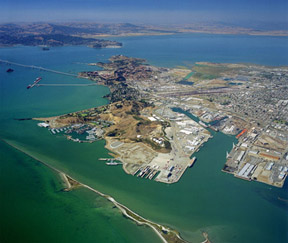
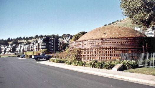
Other than the south shore, Richmond’s other area of dramatic residential development is Point Richmond’s Brickyard Cove, which is hidden in a secluded cove not far from Ferry Point and the Port of Richmond’s Terminal No. 1, where the Red Oak Victory is now berthed. Brickyard Cove is where, for many years, bricks were produced in large kilns for use in buildings throughout the Bay Area. The old plant hasn’t operated for decades, but some of the old brick kilns have been retained as a monument. In recent years, Brickyard Cove has been discovered as a sheltered area with magnificent views of San Francisco across the Bay, and is currently in the midst of a housing boom.
Established during the 1960s, the Richmond Yacht Club’s vast marina at Brickyard Cove probably sparked the cove’s development, with several hundred nearby custom-built homes built on landfill or pilings, together with a couple of office buildings and more recently an Executive Center. Meantime, on the hillside adjacent to the brickyard’s quarry, 240 condominiums have been built, with 70 more currently being added to meet the demand.
Until recently, the development at Point Richmond was impeded by its remote location, accessible only through a long, dark tunnel and an industrial drive past the marine terminal and a tank farm belonging to a former vegetable oil plant. All of that changed when the national luxury-home builder Toll Brothers became interested in Brickyard Cove, and built a direct access road over the hill from the Canal Area of Richmond. Currently, Toll Brothers is completing its “Seacliff” project, 149 luxury homes, most of which have already been sold.
The most recent development is the city’s sale of Terminal No. 1 and the adjacent tank farm to Toll Brothers. The tank farm will be cleaned up and the terminal warehouse will be torn down by the city, leaving a 16-acre site with direct water access upon which Toll Brothers plans another development, Point Richmond Shores, comprising 289 luxury condominiums.
Other residential developments at Brickyard Cove appear to be in the pipeline, including one by Signature Properties. So, adding current residents to future residents of the various developments would mean that there should be at least 3,500 upscale residents at Brickyard Cove, many of whom would have jobs in San Francisco and be interested in direct ferry service. Even after the warehouse has been removed, Terminal No. 1 will still retain its wharf and docking facilities for tying up boats and ferries, although the site will be without parking. Perhaps a shuttle bus service could connect to a ferry service that would make a single stop at Brickyard Cove between San Francisco and a possible terminal along the main ship channel near the Ford Building.
The Casino Scene Moves to Point Molate
Indian-owned casinos have become the latest cash cow for the financially strapped cities of California. Several casinos have been proposed in and around Richmond, but the casino/resort proposed for the former Point Molate Naval Fuel Depot, located within city limits north of the Richmond-San Rafael Bridge, appears to have the greatest momentum, at least as far as the City of Richmond is concerned. However, its isolated waterfront
location will require not only an improved access roadway and an enlarged I-580 interchange, but also ferry service to San Francisco to bring locals and tourists to the gaming tables.
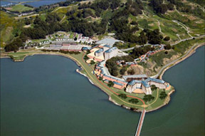
Point Molate is located on Point San Pablo, which jets out into the Bay with an abandoned whaling station and a shipping terminal once used by the Port of Richmond at its point, the remnants of Chinese shrimp fishing stations along its shores, and the Chevron-Texaco oil refinery on the other side of its 500-foot ridge. Point Molate came alive after the 1906 Earthquake, when the California Wine Association’s buildings in San Francisco were destroyed, and the organization sought a new location for its winemaking operations. The site was found along the bayshore at Point Molate, which provided access by both water and rail. The association built an 1800-foot wharf, a company town, and an imposing structure called Winehaven for aging and bottling wines. Even today, Winehaven is an imposing structure with a massive steel-and-concrete building with turrets, parapets, and a brick exterior. Winemaking continued until Prohibition in 1920 when operations came to an end.
Very little happened at Point Molate until World War II. Then, the U.S. Navy needed a fuel supply depot in the Bay Area, so they purchased the Winehaven property plus an additional 400 acres. Oil storage tanks were built along the ridge, and a pier was extended into the Bay where Navy ships could refuel. In the post-war years, after many of the Bay Area’s Naval installations were closed, the Point Molate Naval Fuel Depot was no longer needed. It was declared surplus, a re-use plan was developed, and the property was transferred to the City of Richmond in 2003. By November 9, 2004, Richmond’s City Council had two proposals before it regarding the former Navy property at Point Molate:
A purchase and sale agreement with Chevron/Texaco that would realize a large immediate infusion of cash ($55 million) and a smaller continuing stream of revenues; and a Land Disposition Agreement with Upstream Investments LLC to develop a resort and casino that would realize a smaller infusion of cash, but a larger stream of long-term revenue, an opportunity for economic development, and a significant number of jobs for the community. The property would “subsequently be taken into trust by the United States for the benefit of the tribe.”
The City Council, after examining the two proposals, chose the agreement with Upstream Investments LLC, which “may potentially provide revenues in excess of $350 million” from the proposed resort and casino. The agreement also provides that Upstream will fully restore key historic structures and provide for the “renovation of the fueling pier that will accommodate ferry service linking the Richmond shoreline with San Francisco.” Upstream will also “widen Western Avenue to facilitate ease of egress off the freeway” and “provide for the acceleration of the environmental cleanup of the site.”
Because of the uncertainties of securing state approval for the casino, Upstream also provided the city with a backup development plan. It would replace the casino “with 800 units of multi-family housing, while maintaining the resort, retail, and hotel elements of the proposal” which would reduce “the estimated potential income from $350 million to about $250 million during a 20-year period.”
Upstream Development’s managing partner is Jim Levine. Other members include John Salmon, former director of the Governor’s Office of Asset Management, and the Cohen Group, headed by the former Secretary of Defense, William Cohen. Upstream is partnered with the Guideville Band of Pomo Indians and Harrah’s entertainment company of Las Vegas.
Jim Levine is a civil engineer who was involved with the development of a wetlands restoration project in Suisun Bay for the disposal of dredged materials from the Port of Oakland. Jim explained that, “Ours is really a resort project with the casino as one element. We’re talking about 85 stores, 15 restaurants and cafes, a shoreline park, a 1,100-room hotel with entertainment, a spa and more. The center of this development is going to be the restoration of the historic Winehaven, which would be the casino itself. It is a wonderful use for it, and we would really not affect the outside of the building. But it’s an expensive project to restore an old building like that. It is a steel-and-concrete structure with a brick face on it. We’ve looked at it, and the restoration can be done quite magnificently. It will be the focal point of the development. There will be two major parking garages and linkages to public transit, including ferries. There will be no cars in the interior of the site, since it is going to be a pedestrian village.”
A Key Role for Ferries
Jim Levine continued, “We think that the Point Molate Resort will bring huge numbers of new tourists to the Bay Area. With a ferry linkage to San Francisco, which we have yet to establish, tourists and business groups will be able to hop on a ferry, and in 20 minutes be at Point Molate. We have a running start at this because the Navy tied 1,100-foot warships to the Point Molate pier in deep water. Retrofitting it for ferries is really doable. So, we are very high on ferry service to San Francisco.”
Because the proposed Point Molate development is so new, the San Francisco Bay Water Transit Authority (WTA) has yet to address its specific needs, but the WTA recently approved an agreement with URS Corp. “for land-use planning and terminal planning service in conjunction with the Richmond Ferry Terminal Site Selection Project.” As we have pointed out, Richmond’s growing number of housing and
commercial developments on the south shore and at Brickyard Cove can be expected to grow the demand for public transit services, including ferries. The Point Molate Resort, although on the opposite side of the Richmond-San Rafael Bridge, will add to the overall demand for ferry service in the area. At the same time, the agreement with Upstream Development puts the City of Richmond firmly on the road toward having an Indian Casino which, the city fathers hope, will pump cash into their depleted coffers.