As Oakland grew into a larger and larger seaport, it’s waterfront became more and more separated from the local community. In fact, many never knew that their city had a waterfront, in spite of the city’s 19 miles of shoreline from the Bay Bridge to the San Leandro city line. As the Oakland Navy Supply Depot is transformed into the Middle Harbor Shoreline Park and Habitat, Oakland opens the door to its waterfront.
Published: April, 2003
As Oakland grew into a larger and larger seaport, its waterfront became more and more separated from the local community. In fact, many never knew that their city had a waterfront, in spite of the city’s 19 miles of shoreline from the Bay Bridge to the San Leandro city line. Between Oakland and its waterfront were the Oakland Navy Supply Depot and the Oakland Army Base, as well as the Port of Oakland’s container terminals. Long-time Oakland residents such as Sandra Threlfall, knowing full well the problems and the frustrations, set out to do something about opening up the waterfront, first through the League of Women Voters and then with the founding of the Waterfront Coalition in 1994. These activists brought pressure to bear on the city and the Port. At the same time, the closing of the Navy Supply Depot and then the Army Base provided opportunities for the city to begin reclaiming its waterfront.
The transfer of the Navy Supply Depot back to the Port of Oakland (it had originally been Port land that was ceded to the Navy during the war for one dollar), opened up the magnificent Middle Harbor Cove that was once a tidal area, but had been dredged to 40 feet to accommodate ships docking at the depot. Citizen groups joined the Port staff, and, after countless meetings, developed plans for the Middle Harbor Shoreline Park. The removal of the piers and warehouses of the Navy Supply Depot and the transformation of the 180-acre cove into a park would finally open Oakland’s waterfront to the people. There are two other parts to this story, however: one is dredging and the other is changing attitudes at the helm of the Port of Oakland.
The Dredging Factor
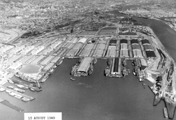
Oakland is not blessed with natural deep-water shipping channels. In its early days, the city built out into the Bay to reach deep water, and the result was the Southern Pacific Mole (now the Seventh Street Marine Terminal) where transcontinental trains met ferries for the last leg of the trip to San Francisco. To the south, a competing railroad built another mole for its trains. In between was a shallow tidal area called Middle Harbor Cove that was transformed into the Oakland Navy Supply Depot during World War II.
Filling the Bay did not solve shipping problems for the Port of Oakland, and the Port was forced to dredge channels so that ships could reach its dockside facilities. The problem grew with the dawn of the age of the container ships, which actually started in Oakland with the world’s first container terminal. As container ships grew larger, the Port had enormous problems in dredging channels deep enough to accommodate them and in finding places in which to dispose of the dredged materials. Initially, the ships needed a 35-foot depth, then 42 feet, and now 50 feet for the large ships that are carrying 4,000 containers and more.
As Will Travis, Executive Director of the Bay Conservation & Development Commission (BCDC) put it, "At one time, the Port of Oakland seemed to have the capability of choosing the worst of a whole gamut of opportunities. First, they were going to take dredged materials to a site in the Bay where it would eventually have to be dredged up and moved someplace else. Next, they selected a site off Half Moon Bay that turned out to be a prime fishing area. Then, they selected a site in the delta, where the farmers didn’t want salt contamination from the material."
Eventually, the Port was forced to choose between one of several costly sites for the disposal of dredged materials, either ocean dumping 50 miles beyond the Golden Gate, landfill restoration projects around the Bay, or cover for upland landfills.
Changing Attitudes
Change was also taking place on another front. With the Port’s selection of Executive Director Chuck Foster, and more recently Executive Director Tay Yoshitani, attitudes were beginning to change, and a new environment began to dawn at the Port.
Will Travis points out that, "It takes a long time to turn an organization around, but with Chuck Foster’s ascension to the executive director’s position, he gathered around him a group of people who were truly committed to the protection of the environment, particularly the Port’s environmental manager, Jim McGrath. They began involving the community in their decisions, and by now, they have institutionalized those changes, with the right people in the right places."
Shortly after Yoshitani took over as Port director, I heard him speak at a business conference, saying that, "There are three things that we will use to measure a project at the Port of Oakland: one is economic sustainability, the second is environmental sustainability, and the third is its contribution to the community." To me, that speech before a business audience showed a lot of courage and a deep commitment to those ideals.
Dredged Materials to the Cove?
At some point in planning for the transformation of Middle Harbor Cove into a park for the people of Oakland, an idea dawned. There was the cove, originally a tidal marsh, which had been dredged to a depth of 40 feet to accommodate vessels at the now closed Navy Supply Depot. Adjacent to the cove was the Oakland Estuary, now 42 feet deep, but which needed a 50-foot depth to accommodate today’s container ships. So, why not take dredged materials, at least the clean sand from the estuary and use it to fill the cove to a depth of about four feet, thereby creating a tidal marsh resembling the pristine condition of the area? The result would be not only a park for people but a habitat for birds and wildlife.
The Port’s environmental director, Jim McGrath, approached regulator Will Travis with the idea. Travis recalls that, "When Jim McGrath first approached me with the idea of creating a tidal basin at the middle harbor, I said, you’re crazy, you’re just trying to find a cheap way of dumping that dredged material. But after he walked me through the idea, I had just two questions: First, will it work? And second, what if it doesn’t work? As it turned out, the project was designed in a fashion that has the greatest likelihood of working, and the Port is committed to taking it away if it doesn’t work. That project was brought before a skeptical BCDC with the support, the strong support, of the environmental community.
"Yes, the Port brought us around. The project was contrary to our policies and our regulations. But ultimately, we changed our policies and our regulations to accommodate that project, because we think that it has a good chance of providing a net benefit to the Bay. By using the savings that are generated by disposing of the dredged material close at hand, the Port now has the economic capability of investing in making the Hamilton wetland project in Marin County and the Monetzuma wetland project in Suisun Bay work. The Port could not have done that if they were not able to take the savings in dredged material disposal costs and reinvest it in other beneficial environmental projects."
Current Activity
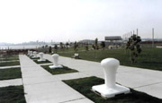
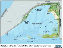
The Middle Harbor Shoreline Park and Habitat is being built in phases. The first phase, completed and in use, includes a fishing pier and a parking area, together with the Seafarers Club (an ecumenical ministry to seafarers from around the world) adjacent to the Seventh Street Marine Terminal. In addition, the Port has moved an historic train-switching tower to the park and refurbished it to create an exhibit called a "Room with a View." On the second floor, visitors can observe operations of the adjacent container terminal, and also see remarkable interpretive exhibits of the area. At nearby Point Arnold, there is a completed 10-acre segment of the park set aside for active recreation, family activities, and picnicking. There is also a large elliptical field suitable for a variety of sports and even a beach, which is still being developed.
From the Point Arnold area, a promenade will lead along the cove through an area of the park that is still being developed and will include habitat areas and a salt marsh with plantings of native grass. At the far end of the cove will be a grassy area known as "The Mole," where a 45-foot observation tower is to be constructed that will provide a 360-degree view into the adjacent container terminal. With the completion of the tower this September, the Middle Harbor Shoreline Park and Habitat will be dedicated, and the operation of the park turned over to a group such as the East Bay Regional Park District.
However, the habitat remains to be completed because of delays in federal funding for dredging the 50-foot channel in the Oakland Estuary. Eventually, however, Oakland’s Middle Harbor will offer not only a park for the citizens of Oakland, but also a habitat for the birds.