Jim Mallory was a Richmond ferry rider
The Pinnacle, a new condominium homes at Brickyard Landing
By Jim Mallory
Published: August, 2001
Jim Mallory was a Richmond ferry rider
Richmond. It’s a 55-square mile city on the northeastern corner of San Francisco Bay whose history and its future is as inexorably tied to boats of all kinds, including ferries, as the tides that lap its shores. In fact, Richmond owes its very existence to being selected by the Santa Fe Railroad as the western terminus of the company’s cross-country rail lifeline that delivered essential goods to San Francisco. Those goods traveled the final five miles across the bay by ferry from Richmond’s Ferry Point. Richmond Mayor Rosemary Corbin calls the city ""the hub of the bay"" because of the transportation options that are available in all directions.
The rush for California gold saw passenger service spring up in Richmond as the lure of riches attracted thousands of people and Captain George Ellis began operating schooners from Ellis landing, about where Richmond Terminal 3 is currently located. At the tip of Point San Pablo, now the site of Richmond Municipal Terminal 4, sardine canneries served by about 100 sardine boats operated during the 1940s, and the last active whaling station operated at a site between Terminal 4 and the Point San Pablo Yacht Harbor until 1968 when it was closed after the U.S. banned whaling. The site later burned and was torn down in 1998.
Ferry Point, the railroad pier where Santa Fe loaded its freight cars onto ferries for the trip across the bay to San Francisco, still stands at the end of Miller Knox Regional Park in the southwest corner of the City. Before the construction of the Bay Bridge East Bay residents could load their cars onto the ferry for a trip to the City. Park officials say funds have been allocated to renovate Ferry Point, allowing local residents to once again fish from the restored pier.
When the United States entered World War II Richmond played an important part in the national defense effort as the Kaiser Shipyards, now the site of several upscale gated housing communities in Marina Bay at the foot of 23rd Street, turned out more than 700 cargo ships to carry war materials to U.S. troops in faraway places. During the war, Richmond grew from a population of 23,000 in 1940 to 123,000 by 1942 and attracted workers from as far away as Arkansas, many of whom shared a bed in shifts until more housing could be built.
The workers, many of them women, launched the SS Robert E. Peary in an astounding and record four days, 15 hours and 26 minutes after laying the first strip of steel that became the keel. One of the ships built at Richmond, The Red Oak Victory, was brought back to Richmond in 1999 and is being restored by a crew of dedicated volunteers, some of whom served on the ship during World War II. Plans call for the Red Oak Victory to be permanently docked at a new park that will be built near the now closed Ford Assembly plant. The factory will be the home for a historic museum organizers hope to construct as part of the World War II Home Front National Historic Park scheduled to open in 2003. The ship was given to the Richmond Museum of History in 1996 by an act of Congress.
Checkin’ Out Richmond
By Nancy Salcedo
It will be nice when ferry service to Richmond is restored. A good portion of the Richmond Bay Trail is completed, and winds through plenty of waterfront open space, marsh, and past 150 years of interesting history. The Rosie the
Riveter Home Front National Historical Park is nicely taking shape here, with three memorials along the Richmond waterfront, and the Red Oak Victory, of which you can arrange a tour. From the Port of Richmond, the Bay Trail continues south to the Berkeley Marina where you can hook up with the Cal Sailing Club and California Adventures for sailing or windsurfing lessons in the South Sailing Basin. From there you can continue south and enjoy the waterfront restaurants on the Emeryville peninsula. For rest and refueling, the town of Point Richmond provides good restaurants and lodging, all while acting as a gateway to Richmond’s parks and historic points of interest located through The Tunnel. Historic and beautiful Western Drive exposes still more of the shoreline’s historic sites from rolling hills above San Pablo Bay. At the end of this road, a boat leaves to take you to the East Bay Light Station for a once in a lifetime opportunity to spend a night in the bed and breakfast lighthouse on an island in the bay.
Visible remnants of the shipyards stll exist. On the east side of the Santa Fe channel is a huge concrete building which served as the general warehouse, and the steel building to its north served as the shipyard’s machine shop. Five concrete basins nearby that served as drydocks for the shipyards are now docking sites for various ships, including two former navy floating machine shops that were used in the storm sequences of the movie, The Perfect Storm.
Ferry service returned to Richmond in September 1999 when Red & White Fleet initiated daily commuter service to and from San Francisco and ferries to PacBell Park for Giants home games, but the commuter service was discontinued 14 months later due to a lack of ridership. However, would-be commuters, local realtors and Richmond officials believe bringing ferry service back to Richmond would be an asset to the economic development of the city. New friendships, some of which still endure, were made on the ferries and many of the commuters still communicate via e-mail and an occasional social gathering.
""I’d love to have ferry service come back. That’s Richmond’s history. We also had a ferry to Marin before the Richmond-San Rafael Bridge was built,"" said Richmond Mayor Corbin."" Just north of that bridge are the remains of the terminal and pier that served ferries from 1915 until 1956 when the 5.5 mile span linking Marin County and Richmond was completed. Today the bridge carries an estimated 60,000 commuters each day. ""Ferries and Richmond have a long happy history together. I’m hoping we can get a ferry back,"" said Corbin.
Corbin said she believes the commuter service failed because the boats were too big and too slow. Commuters who rode the ferries disagreed, claiming the service was inadequately promoted. According to ferry operator Red & White Fleet ridership less than 50 people used the commuter service each work day. The boats used for the daily commute took about 50 minutes to make the one-way trip and had a passenger capacity of over 300 people. ""Hopefully we can get a more appropriately sized ferry and one that can offer a faster commute,"" the mayor told Bay Crossings.
Corbin said restoring ferry service would give the city another transportation option and remove cars from the freeway. She is optimistic that one day in the not too distant future ferries will once more ply the waters of the Richmond Channel. ""It’s not going to happen this year, but we are looking at possibilities. PG&E, before they filed for bankruptcy, was considering applying for a demonstration grant to run a clean ferry of smaller dimensions. People are trying to figure out how to get money. The problem is there are no public transportation modes that don’t have large subsidies. Our ferry was not being subsidized,"" said Corbin.
The Mayor said the city has grown and changed significantly in the last few years. ""The direction we are going is more diversity in terms of types of businesses. We are developing both housing and businesses so that what we call ‘jobs to housing balance’ is pretty good."" The mayor’s vision for Richmond includes a wider variety of employment opportunities as well as more variety in housing opportunities.
Richmond’s strategic location on the bay is a tremendous asset, says the mayor. ""We have 32 miles of shoreline, so in addition to port we have upscale housing of all sorts, from apartments to huge luxury houses. We have the (Chevron) refinery and we have four marinas. We have the Bay Trail, wonderful recreational opportunities, opportunities for employment and opportunities for living with great bay views.""
The Bay Trail, which will one day link the entire Bay Area waterfront, is now intact between Richmond’s Marina Bay and Point Isabel. From Point Isabel, Eastshore State Park stretches seven miles to Radio Point Beach near the Bay Bridge Toll Plaza. En route are piers, great bay views, shoreline parks, marinas and numerous waterfront restaurants to choose from. One of the trail fingers out into the bay takes you out to the Emeryville peninsula, which hosts Trader Vic’s, and other restaurants that provide classic waterfront dining. At the tip of Emeryville Peninsula is Marina Park, and the Emeryville Fishing Pier with 360-degree bay views. The Berkeley Marina has 5 miles of trails, more restaurants, a small craft launching dock (where Cal Sailing Club and California adventures offer instruction,) the Shorebird Park Nature Center and Adventure Playground, and a popular Recreation Pier that brings you 3,000 feet out over the Bay. From the pier’s end, you can see the remnants of the earlier Berkeley Ferry Pier which, in the old days, went out 3.5 miles to water deep enough to dock large ferry boats. This ferry service, however, ended when the Bay Bridge was completed.
The Bay Trail enters Richmond from the south at Point Isabel. From here to Marina Bay is the most popular. At Point Isabel you can indulge at K-9 Coffee for an
espresso (so named because this is a popular dog park-they even have Mudpuppies Tub & Scrub dog wash here.) You continue north along the shoreline to Marina Bay, which bears little resemblance to the former industrial site, Kaiser Shipyard #2, that was here before. In fact, most of the shoreline between the marina and Potrero Point was occupied by Kaiser Shipyards during W.W.II.
Corbin acknowledges that some people may think of Richmond as a city known only for its high crime rate and high unemployment. But she says the city has changed a great deal in the past few years. She said the crime rate has dropped over 50 percent, and according to Contra County officials unemployment, which is under five percent, is at an all-time low. ""It’s easy to get a bad reputation and hard to get over it,"" said the mayor. ""That image was formed decades ago. They ought to come take a look,"" she said.
Richmond City Manager Isiah Turner also supports the return of ferry service. ""Ferries are an asset for the working population,"" said Turner. ""With our population growth in the next 10 years the roads will be crowded. The ferry can provide service between Richmond and San Francisco for workers, and people will come to Richmond to tour the waterfront."" Turner said the daytime labor force in Richmond currently numbers about 50,000, with about 40 percent of the city’s working residents employed outside the city.
The waterfront Turner refers to is Richmond’s 32 miles of shoreline , more than any other city on the Bay, and includes a significant section of the Bay Trail as it follows the eastern curve of the bay along Interstate 580 then turns west through 21-acre Pt. Isabel Regional Shoreline, the Marina Bay Esplanade and Miller Knox Regional Park, then follows the shoreline northeast through Wildcat Creek to Point Pinole.
City officials see the trail, while still incomplete in some places, as a significant tourist attraction and a key element in their five-year vision statement. The trail, with its wetlands teeming with waterfowl as well as opportunities for bay fishing, jogging and running, bird watching, kite flying and dog walking, is expected to attract tourists from San Francisco. Pt. Isabel Regional Shoreline is one of the few parks in the East Bay where dogs can legally run off-leash.
""As the Bay Trail develops people are able to go farther and they find out about communities they haven’t known about before. Richmond is one of the communities benefiting from people coming and seeing what a marvelous place this is,"" said Mayor Corbin. City officials are considering the possibility of using water taxis or small ferries to close the existing land gaps in the trail at the Santa Fe Channel and at Wildcat Creek, according to information on the city web site (www.ci.richmond.ca.us)
Other attractions expected to attract visitors include the historic Ford Assembly Plant adjacent to the now unused ferry landing at the foot of Harbor Way. Originally built on the bay to assemble and ship automobiles, the plant turned out tanks for the Army during World War II and is now listed on the National Register of Historic Places. Richmond is currently seeking proposals for redevelopment of the building, which they hope will include a museum, waterfront apartments, retail and office space and a small transportation museum.
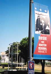
The Richmond museum already has obtained the very first car produced at the plant, a black 1931 Ford Model A. ""It was built for the Richmond City Manager, it’s in excellent shape and it still runs,"" said Richmond Museum Assistant Curator Shelby Sampson. The museum periodically conducts historic tours of the city of Richmond. An October tour will focus on areas involved in the World War II homefront effort, such as the shipyards and the recently dedicated ‘Rosie the Riveter"" Park, named in honor of the women who worked in the defense industries of World War II, including the Kaiser Shipyards in Richmond. The park features a gigantic piece of art by artist Susan Schwartzenberg, who won a national competition with her 441 foot long bronze ribbon that represents the length of the Liberty Ships built at Richmond. A sloping ""Keel Walk"" leads to the water’s edge and a propeller from one of the original Liberty Ships.
Brooks Island, lying just a half-mile off shore from the Richmond Marina is the largest of the four islands within the Richmond city limits. Now a regional shoreline preserve operated by East Bay Regional Park District and closed to the public except for visit by permit, the former rock quarry provided some of the rock used to construct a portion of San Quentin. Most recently the island was a private hunting preserve for a small club which included crooner Bing Crosby. Pheasants descended from those once hunted on the island now keep the island’s resident caretaker company.
Local property developers, realtors and business executives also believe ferry service between Richmond and San Francisco would benefit the community and recruiting efforts.
""There is a definite interest here from our employees who live in the city. They are quite interested,"" said Sangamo BioSciences Inc. Senior Director of Corporate Communications Julie Wood. BioSciences, a biotech company that focuses on gene regulation research, is located a short walk from the now unused ferry landing at the foot of Harbor Way South.
Providing a link to that past, there are three memorials pertaining to Rosie the Riveter National Historical Park along the Bay Trail in Marina Bay: The Shimada Peace Memorial, named for the City of Shimada, Richmond’s sister city in Japan, and dedicated to peace following the war; Shipyard Stories Memorial with its oral histories and historic photographs located at Barbara and Jay Vincent Park; and the enlightening Rosie the Riveter Memorial in Marina Park. When it is completed, the National Historical Park will incompass all of the former Kaiser Shipyard sites on Richmond’s waterfront, as well as additional historical points of interest elsewhere in the city, like the original Kaiser Field Hospital, worker’s housing at Atchinson Village, and two still-operating day care centers that served the workers’ children during the war. In all, the park will include 14 sites within walking distance of each other. For now, the existing memorials combine with some of the greatest shoreline trails in the bay area for an informative and beautiful walk or bike ride. Eventually, the craneway of the Ford Assembly Building will house the park’s Home Front Visitor Center.
The Rosie the Riveter memorial is a fascinating place. W.W.II was one of the biggest things to ever happen to Richmond. During the war, workers were recruited from throughout the country, especially in the south and midwest, for jobs building liberty and victory ships at the Kaiser Shipyards. Few people probably know the story of the women who came with their families to Richmond to work in the shipyards, and how their efforts on the home front helped build Roosevelt’s ""Arsenal of Democracy"" that served the United States during W.W.II. The Kaiser Shipyards built more ships faster and better than anyone ever before. Rather than a woman named Rosie, the Rosie memorial commemorates the tens of thousands of women who went to work in the shipyards, who became collectively known as Rosie the Riveter. As the oral histories along a timeline here point out, Richmond’s population quadrupled from 25,000 to 100,000 people in response to the workload at the Kaiser Shipyards. Henry Kaiser became a pioneer in providing managed health care for the workers and child care for their families, rendering Kaiser Shipyards the county’s first employer to provide such services for workers. From here Kaiser Permanente evolved into the nation’ss first HMO, and changed forever the way industry employs society.
Another employer that could benefit from bringing ferry service back to Richmond is Contra Costa County. The County has leased a 60,000 square foot facility on Hall Ave., about three blocks from the ferry terminal. Facilities Manager Michael Jameyson said more than 300 employees of the county’s Employee and Human Services Department who now work in Richmond and Hercules will move to the new facility. That could happen as early as November 2001, according to Jameyson. He said access to San Francisco via ferry would benefit workers at the new facility, which has enough room for the department to expand.
""We were very disappointed to learn that the ferry was cancelled,"" said Jameyson. ""The potential that the ferry might be re-activated would be a big plus. The more public transportation the better,"" he said.
Jeff Leenhouts, a sales associate at BT Commercial in Oakland, is the leasing agent for commercial properties near the Richmond ferry landing. He said ferry transportation to and from San Francisco would make it easier to attract the companies the city wants to bring to Richmond.
""It would raise the level of the types of employees. Companies would feel they could attract employees (from San Francisco), and it’s always good to mention ferry access within walking distance. It helps tremendously,"" said Leenhouts.
Once a shipyard town, city leaders are now dedicated to bringing what they call ""clean"" businesses to the area to take advantage of cheaper land and an available labor force. ""We want to diversify our economy,"" Mayor Corbin told Bay Crossings. We have already attracted biosciences companies like Berlex Biosciences and Dicon Fiber Optics Inc., and several other fiber optic companies.""
""Eight years ago we began an economic renaissance,"" said City Manager Turner. We are no where built out and land prices, while up, still are less expensive."" Turner said several thousand new homes, with price tags ranging from $80,000 to $700,000 are being built or are planned. ""Those will help us recruit ‘clean’ companies and provide housing for their staff and executives,"" said the city manager.
Turner said people who will eventually work at the companies who locate at Point Molate, a former U.S. Navy fueling depot at the east end of the Richmond-San Rafael Bridge that is expected to be turned over to the city within a year, will also benefit from ferry service. How the area will be developed still hasn’t been decided, said Turner.
Despite its renaissance, Richmond is still a port town. Port Director Jim Matzorkis said the city is building new facilities at the 200-acre port to handle increased business, which could soon include automobiles arriving from factories in Japan. ""That puts Richmond back on the automobile map,"" said Matzorkis.
Unlike neighboring port Oakland, Richmond’s port specializes is handling non-containerized, or bulk cargo including food oils. Matzorkis said the new facilities will allow the port to double its present operating revenue in the next two to three years.
Richmond is definitely a waterfront city. Many citizens and city officials are working hard to bring ferry service back to Richmond. Meantime new houses are being built with price tags ranging from $80,000 to $700,000, job training programs tailored to the employer’s needs, a downtown transit village that includes a new BART garage and housing units, a $35 million revitalization of the Easter Hill public housing project and $50 million in bonds to repair the city’s 100-year old infrastructure are signs the city may be a place to both live and work. And the numerous signs erected by the state to direct travelers to the ferry landing still stand at numerous locations along I-80 and I-580, pointing the way to what many hope will once again be an active ferry service.
When the war ended, the shipyards closed, and the resulting loss of work left the community in economic despair that the town is just beginning to recover from. Students from Richmond’s Kennedy High School are at work on an oral history project of their own, photographing and interviewing the local Rosies. The memorial is designed to evoke the scale and forms of Kaiser-built ships. It is sited on the launch site of the former shipyard, its 441’ length representing that of a keel. The hull is 18 feet tall, with the fantail out over the water. You can visit the last original Liberty Ship, the Jeremiah Obrien at Fort Mason in San Francisco.
Just north of the Rosie memorial, you can enjoy a fabulous waterfront meal at Salute’s or grab a gourmet sandwich at Amini’s next door. From Marina Bay, you can take surface streets to Sheridan Observation Point, at the southern end of Harbor Way. Here, you can view the Port of Richmond’s gantry cranes in action moving cargo between ship and shore along the Santa Fe and Inner Harbor channels. Sheridan Observation Point is on the former site of Kaiser Shipyards #1 and #4. Across the water is Kaiser Shipyard #3, Richmond’s only remaining historic Kaiser Shipyard. The long, brick, neoclassical building adjacent
on the other side of the point is the Ford Building, which will soon house the visitor center for the Rosie the Riveter National Historical Park. On the National Register of Historic Places, this is a huge, and, in its time, innovative assembly building used by Ford until 1954. The first Model A Ford built in Richmond is on display at the Richmond Museum of History on Macdonald Avenue. Richmond’s longed-for ferry’s terminal is located here, too.
Richmond Greenway Receives $1.9 Million Capitol Funding Grant
The Metropolitan Transportation Commission recently announced recommendation of $1.9 million in Transportation for Livable Communities (TLC) funding to construct a trail and greenway on 2.5 miles of abandoned Santa Fe Railroad right-of-way. The trail project, sponsored by the City of Richmond, Rails-to-Trails Conservancy, and the Community Youth Council for Leadership and Education (CYCLE) will create a link to local and regional parks and trails, schools, Richmond BART/Amtrak station, downtown shopping and newly proposed residential and commercial developments, including a new affordable housing development.
MTC received 39 capital project applications totaling about $46 million in requests. Approximately $9 million is available in federal funds for TLC capital projects through the Transportation Enhancements and Congestion Mitigation and Air Quality programs for this cycle. For more information contact Kate Bickert at RTC(kbickert@transact.org) or Judith Henderson at CYCLE (c-y-c-l-e@email.msn.com).
The Richmond Greenway will hook up with the Ohlone Greenway at San Pablo Avenue, where a portion of Baxter Creek surfaces ( see www.creativedifferences.com/baxtercreek.). The Ohlone Greenway is a landscaped linear park along the former Santa Fe right of way in Albany and El Cerrito, where it parallels the BART right-of-way. Albany’s section is broader and more attractive than El Cerrito’s, but there are some interesting sections in El Cerrito, including crossings by two branches of Cerrito Creek, a recently daylighted bit of creek near El Cerrito’s City Hall, and a garden featuring plants that have been around since the Jurassic. For more information about the history of the Ohlone and Richmond Greenway, see www.bpfp.org/SFRW/OhloneGreenway.htm.
The terminal site is historic in that it was also the point of departure for Richmond’s Santa Fe trains and ferryboats heading to Tiburon and San Francisco from 1900 until the 1960s, and then again for a short time in the aftermath of the 1989 Loma Preita earthquake to ease traffic congestion while the Bay Bridge was closed.
From the Sheridan Observation Point is a great view of Brooks Island. The island is sacred to Native Americans. Access to Brooks Island is by reservation only, and is accessible by East Bay Regional Parks District’s Brooks Island Kayak trips. Trips offer an easy, short 0.5 mile paddle in the protected bay water to the island. Introduction on equipment and strokes is provided along the trip through the Richmond Harbor, followed by a paddle along the shoreline of the island, and a visit to the sand spit for potluck lunch and a two-mile hike around the island.
Hoboken Success Story Model for Richmond
Ferry service has been particularly good to Hoboken, New Jersey. The suburban town is directly across the river from the New York City neighborhoods of Greenwich Village, Chelsea, and Hell’s Kitchen, and a ferry runs between Hoboken North and Manhattan in only 5 minutes. One of the most interesting and historic buildings in town is the Hoboken terminal built in 1907 which has 6 ferry slips and tiffany glass skylights in its ceiling. The terminal is unique in that it is also the terminus of New Jersey Transit Railroad. The only other intermodal terminal in the country that served both ferries and rail was here,
in Tiburon. In the early 1900s, ferries carried commuters between the New York waterfront and Hoboken, but service dwindled in the 1950s. Being just one mile square, Hoboken is a self-proclaimed small town, and it stagnated when the Manhattan-Hoboken run ceased in 1967. When compared to hip Manhattan, Hoboken was not.
It was Arthur Imperatore who brought ferry service back to the area in 1985. Arthur was a Hudson County waterfront property owner who felt it might be time to stir things (and property values) up. His previous involvement in the trucking business had provided him the insight to understand both the cost of driving and value of transit. His plunge into the ferry business drew doubt from most who thought the concept was a waste of money sure to end in bankruptcy. ""Arthur’s folly"" they called it. That was over
fifteen years ago. Today, transporting 35,000 passengers each day, he currently runs the largest privately run ferry transit business in the United States. And, best of all, Hoboken is gaining hip status, even when compared to Manhattan. Why just last year, independent book publisher John Wiley & Sons, Inc., who had been publishing in Manhattan for the last 170 years (making it the oldest in the business in the United States) signed a lease to move its headquarters to the Southern Waterfront Development in Hoboken. Next, the Sierra Club, encouraging
projects that make neighborhoods friendly to people on foot, offer residents public transportation options, and create a healthy balance of shops, jobs, and housing around a downtown or mainstreet, named Hoboken’s same Southern Waterfront as one of the best examples of a development project in their national report entitled ""Smart Choices or Sprawling Growth.""
Hoboken works because its got commuter rail, (and a subway rail (PATH) connecting the Arthur’s NY Waterway ferries’ 5 minute ride from Manhattan. The region’s most active intermodal facility, ""Arthur’s folly has become Arthur’s fable,"" muses Carter Craft of the Metropolitan Waterfront Alliance (MWA), a growing network of
organizations and individuals dedicated to helping the region reclaim and reconnect to the harbor, rivers and estuaries of the NY and NJ waterfront. The MWA provides grassroots efforts to facilitate environmentally sustainable and appropriate development. MWA hosts shipboard tours of the Port of New York and New Jersey to increase public awareness of the port and to encourage environmentally sustainable economic development. One of MWA’s tours visits the Hoboken Terminal, and the Battery Maritime Building in Lower Manhattan, which is being considered for use in helping to accommodate the region’s expanding ferry system. These tours are meant to increase public awareness of the potential for such underutilized resources. There are 47 municipalities under the MWA’s umbrella, and they all have to work as one. As Carter points out ""You can’t build a transportation system by building one stop.""
One of MWA’s goals is a regionwide ferry system to link waterfront communities. In that direction, MWA is currently studying the feasibility of a New York Harbor Ferry Loop, in which 7 day service would connect 25 waterfront sites and 2 dozen cultural and recreational attractions on the waterfront of the Upper Bay. To get things rolling, MWA uses education, grass roots organizing, and media advocacy to include the public’s voice in decision making. To help connect the regions’ waterfront, MWA, basically an on-line community center for the metropolitan area’s current waterfront issues, publishes Waterwire, an electronic newsletter covering waterfront and watershed issues throughout the region. For more information, visit www.waterwire.net
Brooks Island shows up on old maps as Rocky, Bird, and Sheep Island. The Ohlone people lived here for over 4,000 years, and shellmounds and burial sites are preserved. Even though in historic times the island has been used for business endeavors like a private hunting reserve and oyster beds, it retains much of its native vegetation and wildlife. The Caspian Terns and Canada Geese who nest here are among the hundreds of native birds who have been sited here.
Where the shoreline is occupied by the Port of Richmond, the Bay Trail is undeveloped from here to Point Richmond, so one must follow surface streets. You can find accommodations along the way at the Quality Inn on Cutting Boulevard, or continue to the historic Hotel Mac in Point Richmond, with 6 rooms that will charm you with their vintage flair.
In fact, the entire neighborhood of Point Richmond is charming. A registered historic district on the National Register of Historic Places, this is the oldest part of Richmond, and many of the original buildings remain. Originally named Santa Fe, Point Richmond began as a railroad town in 1897. The Richmond History
Association operates a visitor center in a tiny building next to the library at the heart of town where you can pick up a map. The place is staffed by old timers who can tell you stories about the old days as you get oriented. There are two small old-time grocers and several good restaurants, like Louis’ Cafe, The Baltic, the Point Orient, and Hotel Mac. Guillermima’s Oriental Antiques is a very special shop you won’t want to miss. So is the woodshop of Shigoto Ya, which provides an opportunity to explore Japanese style woodwork. Inside, Gordan Hirano, along with partner
Frank Zia constructs custom cabinets, screens, fences, decks and other Japanese accents for both interiors and exteriors that are highly prized by Shigoto Ya’s many local resident customers. In fact, their reputation has extended their work throughout the Bay Area. 2000 Treasures, a couple of doors down with a wide range of treasures (as the name implies) from distant points of the globe, and near-wholesale candle prices.
The large, intriguing building in Point Richmond adjacent The Tunnel is the Richmond Municipal Natatorium, or the Plunge, Richmond’s indoor swimming pool built in 1911 as an exploratory oil well. Instead of oil, they found water, a pool was built, and has remained open since 1924. Next to the plunge is The Tunnel, which opened in 1915 to allow for passage through Nicholl Knob. The Tunnel is graced by one of John Wehrle’s murals. John Wehrle is a Richmond muralist who adds a sense of whim to the Richmond street scene at other sites as well, like the 150’ mural at the Macdonald Avenue I-80 underpass off San Pablo, which depicts a mirror image of the street with a ghost trolley and passengers from 1908 materializing across from the freeway onramp. He has done another one at Barrett and San Pablo Avenue, depicting Ohlone and early Californios interacting with current residents on a street scene of storefronts with historical references. Beyond the mural, The Tunnel leads to Miller Knox Regional Park, Ferry Point, the Red Oak Victory (which is slated to move closer to the Rosie the Riveter Memorial), and eventually ends at the Brickyard Marina.
Miller Knox Regional Shoreline houses the Golden State Model Railroad Museum where you can watch 5 working model trains in action and. You can hike the to the
top of Nicholl Knob in the hills for fabulous views of the bay. Keller Beach provides shoreline access, with a sandy beach. At the southern end, Ferry Point, also an East Bay Regional Park, has a nice walk out to the original pump house building and pier from the old Santa Fe Terminal. This was the western terminus of the Atchinson, Topeka and Santa Fe railroad, which from 1900, ran ferries, tugs, and barges to San Francisco and China Basin. Santa Fe continued barging freight cars to China Basin well into the 1980s. For a short time in the late 1920’s, the Southern Pacific’s Golden Gate Ferry Terminal was located nearby, just west of Richmond Terminal #1, at the foot of Dorman Drive. Richmond Terminal #1 is visible to the south from the shoreline, and from Ferry Point you can see the bough of the Red Oak Victory, which is being lovingly restored here. The ship is open for tours weekends through the Richmond Museum. Some of the volunteers working to restore the Red Oak Victory are women who helped build the ships.
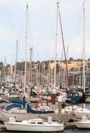
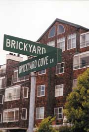
You can continue around the corner into the Brickyard Cove, home of the Brickyard Cove Marina and the Richmond Yacht Club. It has been built around the kilns and smokestack of the Richmond Pressed Brick Company, the last to close down of Richmond’s local brickyards. Richmond Pressed Brick Company was around at the turn of the century, and supplied brick for the rebuilding of San Francisco after the 1906 earthquake. The brick kilns and smokestack have been preserved by the developers for character. All’s Fair restaurant in the Brickyard Marina offers tasty waterfront meals.
From Point Richmond, you can take surface streets to Western Drive. From the base of the Richmond-San Rafael Bridge, this 4-mile, paved road leads past some of the area’s more colorful history-an old Chinese shrimp village, a whaling station, and a castle that housed Richmond’s first and only winery, before heading through the Point Molate US Naval Fuel Depot, and out to the San Pablo Yacht Harbor. From here the boat departs to take you to historic East Brother Light Station. Western Drive also delivers great views of the Bay and the Richmond-San Rafael Bridge. The bridge was completed in 1956, built in part as a result of a series of ferry strikes that badly maimed regional transportation. In addition to carrying traffic, the bridge now houses a colony of nesting cormorants. With up to 300 nests in this group, biologists have scaled the bridge and learn more about cormorant behavior. They contemplate that the cormorants are here, in part, to feed on the humming toadfish that migrate in the bay in the summer months, providing a food source for the cormorants, who, at that time of year, are feeding their young.
Along Western Drive, you will pass Castro Point, site of the Richmond-San Rafael Ferry Terminal from 1915 until Richmond-San Rafael Bridge was opened. Nearby Point Molate Beach Park, is the site of a Chinese Fishing Village that bustled here from the 1860s to 1912. In its heyday, the village consisted of about 30 shacks and several wharves, where shrimp were harvested and either sold locally, and dried and sent to China. Traces of the village have since been reclaimed by the bay. Off shore is Red Rock, also known as Golden Rock in the past, in reference to the legend of treasure hidden here in the days when pirates patrolled the bay. This was also the site of the Red Rock Fishing Resort in days gone by. Back on Western Drive, you soon enter the Naval Depot. A sign directs you to stop at the Visitor Center if you plan to do anything but pass through to the Yacht Harbor. They have historic photographs of the area worth checking out. Nearby is Winehaven. (""Our castle,"" boasts Mary, lifetime Point Richmond resident and docent at the Richmond History Association museum.) This fabulous brick building indeed maintains the architectural lines of a castle. From 1906 to 1919, Winehaven was one of the world’s largest wineries. Conveniently located near shipping lanes and rail service, grapes were brought here from all over California, and wine made here was shipped all over the world. Winehaven produced over 60 wines, as well as brandy and champagne. In its heyday, it’s ships carried barrels of wine across the bay daily to San Francisco. Prohibition officially halted operations in 1919. The buildings are national historic landmarks, and were used by the Navy fuel depot from 1941 to demilitarization in 1995.
Western Drive continues along the shoreline to Point Orient, where the East Brother Light Station comes into view, then climbs up and over a hill to the San Pablo Yacht Harbor. Overlooking the San Pablo Bay, and isolated from the rest of the world by hills covered with sticky monkey flower and coyote bush, the harbor is delightfully worlds away from modern times. The harbor changed hands recently, which has triggered a remodel of The Galley restaurant here. It will be re-opening soon for harborside meals. This harbor is near the site of a former whaling station, but, the station buildings (to the west of the harbor) have since burned to the waterline. Now stumps in the water there are all that’s left of Point San Pablo’s whaling days. The whaling station here at Point San Pablo was in business from 1956 until 1971, and whales caught in the Pacific were brought here for processing. San Francisco was, by the late 1800s, the world’s largest whaling port, but the whaling industry collapsed when petroleum replaced whale oil, and steel replaced whale bone. Whaling everywhere ended when the fishery was closed down by the federal government’s ban on commercial whaling in 1971. There was also a small sardine port and processing point near the tip of Point San Pablo during the 1940s which thrived until that fishery collapsed. You can still try your hand at fishing with one of the sportfishing outfits out of Point San Pablo Yacht Harbor.
If you are continuing on to the East Brother Light Station, you can see the remains of the whaling station from the boat, the last whaling station on the west coast. The boat delivers you to a 5-foot ladder which you must negotiate from the bobbing boat to the island. Upon your successful completion of the journey, you will be pampered at the inn by the exquisite accommodations and gourmet food offered at the 1878 lighthouse. Or, if you’ve just come for the day, you can bring a picnic, have a lighthouse tour, and relax for the afternoon. The lighthouse was manned by Lighthouse Services personnel until it was automated in 1969. It was decommissioned and restored by local preservationists in 1980.
If you’d like to see more of San Pablo Bay, you can take AC Transit, or the bike surface streets to Point Pinole Regional Shoreline, which is, with over 2,000 acres, one of the bigger East Bay Regional Parks. Here you can hike 11 miles of trails, watch for colonies of monarch butterflies who migrate here to flock the eucalyptus trees, or take the shuttle to the pier which juts over 1,200 feet out into San Pablo Bay. From the pier, you can appreciate this large open shoreline, a breath of fresh air in the lair of the East Bay’s oil refineries. Like most of the bayshore, this little peninsula has an interesting past. The Giant Powder Company moved here in 1892 and set up the company town of Giant, along with its plant to produce explosives used throughout the world in major earth moving efforts. Since 1960, when the company left, the company town became part of a residential development, and mother nature has taken over the rest. All that remains are some in-cognito, blast-pro
Brickyard Cove Marina