The Metropolitan Transportation Commission recently announced recommendation of $1.9 million in Transportation for Livable Communities (TLC) funding to construct a trail and greenway on 2.5 miles of abandoned Santa Fe Railroad right-of-way. The trail project, sponsored by the City of Richmond, Rails-to-Trails Conservancy, and the Community Youth Council for Leadership and Education (CYCLE) will create a link to local and regional parks and trails, schools, Richmond BART/Amtrak station, downtown shopping and newly proposed residential and commercial developments, including a new affordable housing development.
Published: August, 2001
The Metropolitan Transportation Commission recently announced recommendation of $1.9 million in Transportation for Livable Communities (TLC) funding to construct a trail and greenway on 2.5 miles of abandoned Santa Fe Railroad right-of-way. The trail project, sponsored by the City of Richmond, Rails-to-Trails Conservancy, and the Community Youth Council for Leadership and Education (CYCLE) will create a link to local and regional parks and trails, schools, Richmond BART/Amtrak station, downtown shopping and newly proposed residential and commercial developments, including a new affordable housing development.
MTC received 39 capital project applications totaling about $46 million in requests. Approximately $9 million is available in federal funds for TLC capital projects through the Transportation Enhancements and Congestion Mitigation and Air Quality programs for this cycle. For more information contact Kate Bickert at RTC(kbickert@transact.org) or Judith Henderson at CYCLE (c-y-c-l-e@email.msn.com).
The Richmond Greenway will hook up with the Ohlone Greenway at San Pablo Avenue, where a portion of Baxter Creek surfaces ( see www.creativedifferences.com/baxtercreek.). The Ohlone Greenway is a landscaped linear park along the former Santa Fe right of way in Albany and El Cerrito, where it parallels the BART right-of-way. Albany’s section is broader and more attractive than El Cerrito’s, but there are some interesting sections in El Cerrito, including crossings by two branches of Cerrito Creek, a recently daylighted bit of creek near El Cerrito’s City Hall, and a garden featuring plants that have been around since the Jurassic. For more information about the history of the Ohlone and Richmond Greenway, see www.bpfp.org/SFRW/OhloneGreenway.htm.
The terminal site is historic in that it was also the point of departure for Richmond’s Santa Fe trains and ferryboats heading to Tiburon and San Francisco from 1900 until the 1960s, and then again for a short time in the aftermath of the 1989 Loma Preita earthquake to ease traffic congestion while the Bay Bridge was closed.
From the Sheridan Observation Point is a great view of Brooks Island. The island is sacred to Native Americans. Access to Brooks Island is by reservation only, and is accessible by East Bay Regional Parks District’s Brooks Island Kayak trips. Trips offer an easy, short 0.5 mile paddle in the protected bay water to the island. Introduction on equipment and strokes is provided along the trip through the Richmond Harbor, followed by a paddle along the shoreline of the island, and a visit to the sand spit for potluck lunch and a two-mile hike around the island.
Hoboken Success Story Model for Richmond
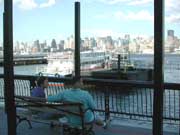
Ferry service has been particularly good to Hoboken, New Jersey. The suburban town is directly across the river from the New York City neighborhoods of Greenwich Village, Chelsea, and Hell’s Kitchen, and a ferry runs between Hoboken North and Manhattan in only 5 minutes. One of the most interesting and historic buildings in town is the Hoboken terminal built in 1907 which has 6 ferry slips and tiffany glass skylights in its ceiling. The terminal is unique in that it is also the terminus of New Jersey Transit Railroad. The only other intermodal terminal in the country that served both ferries and rail was here,
in Tiburon. In the early 1900s, ferries carried commuters between the New York waterfront and Hoboken, but service dwindled in the 1950s. Being just one mile square, Hoboken is a self-proclaimed small town, and it stagnated when the Manhattan-Hoboken run ceased in 1967. When compared to hip Manhattan, Hoboken was not.
It was Arthur Imperatore who brought ferry service back to the area in 1985. Arthur was a Hudson County waterfront property owner who felt it might be time to stir things (and property values) up. His previous involvement in the trucking business had provided him the insight to understand both the cost of driving and value of transit. His plunge into the ferry business drew doubt from most who thought the concept was a waste of money sure to end in bankruptcy. "Arthur’s folly" they called it. That was over
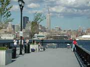
fifteen years ago. Today, transporting 35,000 passengers each day, he currently runs the largest privately run ferry transit business in the United States. And, best of all, Hoboken is gaining hip status, even when compared to Manhattan. Why just last year, independent book publisher John Wiley & Sons, Inc., who had been publishing in Manhattan for the last 170 years (making it the oldest in the business in the United States) signed a lease to move its headquarters to the Southern Waterfront Development in Hoboken. Next, the Sierra Club, encouraging
projects that make neighborhoods friendly to people on foot, offer residents public transportation options, and create a healthy balance of shops, jobs, and housing around a downtown or mainstreet, named Hoboken’s same Southern Waterfront as one of the best examples of a development project in their national report entitled "Smart Choices or Sprawling Growth."
Hoboken works because its got commuter rail, (and a subway rail (PATH) connecting the Arthur’s NY Waterway ferries’ 5 minute ride from Manhattan. The region’s most active intermodal facility, "Arthur’s folly has become Arthur’s fable," muses Carter Craft of the Metropolitan Waterfront Alliance (MWA), a growing network of
organizations and individuals dedicated to helping the region reclaim and reconnect to the harbor, rivers and estuaries of the NY and NJ waterfront. The MWA provides grassroots efforts to facilitate environmentally sustainable and appropriate development. MWA hosts shipboard tours of the Port of New York and New Jersey to increase public awareness of the port and to encourage environmentally sustainable economic development. One of MWA’s tours visits the Hoboken Terminal, and the Battery Maritime Building in Lower Manhattan, which is being considered for use in helping to accommodate the region’s expanding ferry system. These tours are meant to increase public awareness of the potential for such underutilized resources. There are 47 municipalities under the MWA’s umbrella, and they all have to work as one. As Carter points out "You can’t build a transportation system by building one stop."
One of MWA’s goals is a regionwide ferry system to link waterfront communities. In that direction, MWA is currently studying the feasibility of a New York Harbor Ferry Loop, in which 7 day service would connect 25 waterfront sites and 2 dozen cultural and recreational attractions on the waterfront of the Upper Bay. To get things rolling, MWA uses education, grass roots organizing, and media advocacy to include the public’s voice in decision making. To help connect the regions’ waterfront, MWA, basically an on-line community center for the metropolitan area’s current waterfront issues, publishes Waterwire, an electronic newsletter covering waterfront and watershed issues throughout the region. For more information, visit www.waterwire.net
Brooks Island shows up on old maps as Rocky, Bird, and Sheep Island. The Ohlone people lived here for over 4,000 years, and shellmounds and burial sites are preserved. Even though in historic times the island has been used for business endeavors like a private hunting reserve and oyster beds, it retains much of its native vegetation and wildlife. The Caspian Terns and Canada Geese who nest here are among the hundreds of native birds who have been sited here.
Where the shoreline is occupied by the Port of Richmond, the Bay Trail is undeveloped from here to Point Richmond, so one must follow surface streets. You can find accommodations along the way at the Quality Inn on Cutting Boulevard, or continue to the historic Hotel Mac in Point Richmond, with 6 rooms that will charm you with their vintage flair.
In fact, the entire neighborhood of Point Richmond is charming. A registered historic district on the National Register of Historic Places, this is the oldest part of Richmond, and many of the original buildings remain. Originally named Santa Fe, Point Richmond began as a railroad town in 1897. The Richmond History
Association operates a visitor center in a tiny building next to the library at the heart of town where you can pick up a map. The place is staffed by old timers who can tell you stories about the old days as you get oriented. There are two small old-time grocers and several good restaurants, like Louis’ Cafe, The Baltic, the Point Orient, and Hotel Mac. Guillermima’s Oriental Antiques is a very special shop you won’t want to miss. So is the woodshop of Shigoto Ya, which provides an opportunity to explore Japanese style woodwork. Inside, Gordan Hirano, along with partner
Frank Zia constructs custom cabinets, screens, fences, decks and other Japanese accents for both interiors and exteriors that are highly prized by Shigoto Ya’s many local resident customers. In fact, their reputation has extended their work throughout the Bay Area. 2000 Treasures, a couple of doors down with a wide range of treasures (as the name implies) from distant points of the globe, and near-wholesale candle prices.
The large, intriguing building in Point Richmond adjacent The Tunnel is the Richmond Municipal Natatorium, or the Plunge, Richmond’s indoor swimming pool built in 1911 as an exploratory oil well. Instead of oil, they found water, a pool was built, and has remained open since 1924. Next to the plunge is The Tunnel, which opened in 1915 to allow for passage through Nicholl Knob. The Tunnel is graced by one of John Wehrle’s murals. John Wehrle is a Richmond muralist who adds a sense of whim to the Richmond street scene at other sites as well, like the 150’ mural at the Macdonald Avenue I-80 underpass off San Pablo, which depicts a mirror image of the street with a ghost trolley and passengers from 1908 materializing across from the freeway onramp. He has done another one at Barrett and San Pablo Avenue, depicting Ohlone and early Californios interacting with current residents on a street scene of storefronts with historical references. Beyond the mural, The Tunnel leads to Miller Knox Regional Park, Ferry Point, the Red Oak Victory (which is slated to move closer to the Rosie the Riveter Memorial), and eventually ends at the Brickyard Marina.
Miller Knox Regional Shoreline houses the Golden State Model Railroad Museum where you can watch 5 working model trains in action and. You can hike the to the
top of Nicholl Knob in the hills for fabulous views of the bay. Keller Beach provides shoreline access, with a sandy beach. At the southern end, Ferry Point, also an East Bay Regional Park, has a nice walk out to the original pump house building and pier from the old Santa Fe Terminal. This was the western terminus of the Atchinson, Topeka and Santa Fe railroad, which from 1900, ran ferries, tugs, and barges to San Francisco and China Basin. Santa Fe continued barging freight cars to China Basin well into the 1980s. For a short time in the late 1920’s, the Southern Pacific’s Golden Gate Ferry Terminal was located nearby, just west of Richmond Terminal #1, at the foot of Dorman Drive. Richmond Terminal #1 is visible to the south from the shoreline, and from Ferry Point you can see the bough of the Red Oak Victory, which is being lovingly restored here. The ship is open for tours weekends through the Richmond Museum. Some of the volunteers working to restore the Red Oak Victory are women who helped build the ships.
You can continue around the corner into the Brickyard Cove, home of the Brickyard Cove Marina and the Richmond Yacht Club. It has been built around the kilns and smokestack of the Richmond Pressed Brick Company, the last to close down of Richmond’s local brickyards. Richmond Pressed Brick Company was around at the turn of the century, and supplied brick for the rebuilding of San Francisco after the 1906 earthquake. The brick kilns and smokestack have been preserved by the developers for character. All’s Fair restaurant in the Brickyard Marina offers tasty waterfront meals.
From Point Richmond, you can take surface streets to Western Drive. From the base of the Richmond-San Rafael Bridge, this 4-mile, paved road leads past some of the area’s more colorful history-an old Chinese shrimp village, a whaling station, and a castle that housed Richmond’s first and only winery, before heading through the Point Molate US Naval Fuel Depot, and out to the San Pablo Yacht Harbor. From here the boat departs to take you to historic East Brother Light Station. Western Drive also delivers great views of the Bay and the Richmond-San Rafael Bridge. The bridge was completed in 1956, built in part as a result of a series of ferry strikes that badly maimed regional transportation. In addition to carrying traffic, the bridge now houses a colony of nesting cormorants. With up to 300 nests in this group, biologists have scaled the bridge and learn more about cormorant behavior. They contemplate that the cormorants are here, in part, to feed on the humming toadfish that migrate in the bay in the summer months, providing a food source for the cormorants, who, at that time of year, are feeding their young.
Along Western Drive, you will pass Castro Point, site of the Richmond-San Rafael Ferry Terminal from 1915 until Richmond-San Rafael Bridge was opened. Nearby Point Molate Beach Park, is the site of a Chinese Fishing Village that bustled here from the 1860s to 1912. In its heyday, the village consisted of about 30 shacks and several wharves, where shrimp were harvested and either sold locally, and dried and sent to China. Traces of the village have since been reclaimed by the bay. Off shore is Red Rock, also known as Golden Rock in the past, in reference to the legend of treasure hidden here in the days when pirates patrolled the bay. This was also the site of the Red Rock Fishing Resort in days gone by. Back on Western Drive, you soon enter the Naval Depot. A sign directs you to stop at the Visitor Center if you plan to do anything but pass through to the Yacht Harbor. They have historic photographs of the area worth checking out. Nearby is Winehaven. ("Our castle," boasts Mary, lifetime Point Richmond resident and docent at the Richmond History Association museum.) This fabulous brick building indeed maintains the architectural lines of a castle. From 1906 to 1919, Winehaven was one of the world’s largest wineries. Conveniently located near shipping lanes and rail service, grapes were brought here from all over California, and wine made here was shipped all over the world. Winehaven produced over 60 wines, as well as brandy and champagne. In its heyday, it’s ships carried barrels of wine across the bay daily to San Francisco. Prohibition officially halted operations in 1919. The buildings are national historic landmarks, and were used by the Navy fuel depot from 1941 to demilitarization in 1995.
Western Drive continues along the shoreline to Point Orient, where the East Brother Light Station comes into view, then climbs up and over a hill to the San Pablo Yacht Harbor. Overlooking the San Pablo Bay, and isolated from the rest of the world by hills covered with sticky monkey flower and coyote bush, the harbor is delightfully worlds away from modern times. The harbor changed hands recently, which has triggered a remodel of The Galley restaurant here. It will be re-opening soon for harborside meals. This harbor is near the site of a former whaling station, but, the station buildings (to the west of the harbor) have since burned to the waterline. Now stumps in the water there are all that’s left of Point San Pablo’s whaling days. The whaling station here at Point San Pablo was in business from 1956 until 1971, and whales caught in the Pacific were brought here for processing. San Francisco was, by the late 1800s, the world’s largest whaling port, but the whaling industry collapsed when petroleum replaced whale oil, and steel replaced whale bone. Whaling everywhere ended when the fishery was closed down by the federal government’s ban on commercial whaling in 1971. There was also a small sardine port and processing point near the tip of Point San Pablo during the 1940s which thrived until that fishery collapsed. You can still try your hand at fishing with one of the sportfishing outfits out of Point San Pablo Yacht Harbor.
If you are continuing on to the East Brother Light Station, you can see the remains of the whaling station from the boat, the last whaling station on the west coast. The boat delivers you to a 5-foot ladder which you must negotiate from the bobbing boat to the island. Upon your successful completion of the journey, you will be pampered at the inn by the exquisite accommodations and gourmet food offered at the 1878 lighthouse. Or, if you’ve just come for the day, you can bring a picnic, have a lighthouse tour, and relax for the afternoon. The lighthouse was manned by Lighthouse Services personnel until it was automated in 1969. It was decommissioned and restored by local preservationists in 1980.
If you’d like to see more of San Pablo Bay, you can take AC Transit, or the bike surface streets to Point Pinole Regional Shoreline, which is, with over 2,000 acres, one of the bigger East Bay Regional Parks. Here you can hike 11 miles of trails, watch for colonies of monarch butterflies who migrate here to flock the eucalyptus trees, or take the shuttle to the pier which juts over 1,200 feet out into San Pablo Bay. From the pier, you can appreciate this large open shoreline, a breath of fresh air in the lair of the East Bay’s oil refineries. Like most of the bayshore, this little peninsula has an interesting past. The Giant Powder Company moved here in 1892 and set up the company town of Giant, along with its plant to produce explosives used throughout the world in major earth moving efforts. Since 1960, when the company left, the company town became part of a residential development, and mother nature has taken over the rest. All that remains are some in-cognito, blast-protecting concrete bunkers.
Though I hope Point Pinole, the shoreline along Western Drive, and the enclave of Point Richmond don’t change much at all, because they are charming the way they are, Richmond’s southern waterfront is very much emerging. As the Rosie the Riveter National Historical Park takes shape alongside the ever developing Bay Trail, coupled with the restoration of ferry service, the Richmond waterfront will draw increasing attention to the natural and cultural attributes of this hard working town. And well deserved attention it will be. Richmond’s waterfront setting is beautiful, and Richmond’s role in the wartime shipyards is a fascinating story worthy of the national interest it has begun to receive. Enjoy your visit to Richmond.
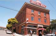
Historic Hotel Mac was built in 1911
