Your relatives back East are coming to San Francisco. They’re still not sure why you migrated to California and want some convincing answers. You’ve got to show the Bay Area at its best. And there’s the clue… the Bay itself… that magnificent body of water that unifies this scenically spectacular region.
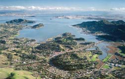
Ferries already serve Marin County from scenic points along the pictured shoreline: Sausalito, Tiburon, and Larkspur. Photo courtesy Robert Campbell, Chamois Moon.
By Michael Nolan
Published: January, 2002
Your relatives back East are coming to San Francisco. They’re still not sure why you migrated to California and want some convincing answers. You’ve got to show the Bay Area at its best. And there’s the clue… the Bay itself… that magnificent body of water that unifies this scenically spectacular region.
To orient your guests, you’ve chosen a trip on the Sausalito Ferry with its marvelous views of the Golden Gate and Bay Bridges, the San Francisco skyline, Alcatraz and Angel Islands, and gentle approach to the Sausalito waterfront.
But hold on a minute, what if this were only the first leg of a circle route around the entire Bay? This exciting water travel experience is exactly what your friends at the Golden Gate National Recreation Area (GGNRA) and the Water Transit Authority are currently envisioning.
GGNRA, a division of the National Park Service, was created by Congress in 1972 and is the largest urban park in the country. It embraces many shoreline parks potentially accessible by boat, including Fort Mason, Fort Baker, Alcatraz Island and Crissy Field in the Presidio. Last year GGNRA initiated a Ferry Access Study on the desirability of water shuttle access to park sites with piers in the Bay "thereby enhancing the visitor experience and providing alternative means (besides automobile) to reach the park."
Using circular or radial routes, a recreational traveler can visit two or three sites in a day with little or no driving required. The options are numerous. Picture boarding a ferry at Fort Mason, crossing the Golden Gate to Fort Baker, then on to Sausalito, Tiburon, Angel Island, Berkeley, Alameda, Candlestick State Park, PacBell Park, the Ferry Building, Fisherman’s Wharf and back to Ft. Mason. These tours can be enhanced with island hops to Treasure and Alcatraz Islands.
The prospect of a Bay circle line that touched down is already inspiring waves of imagination.
Have we been missing the boat?
"I believe that our most underutilized resource in San Francisco is the Bay," comments John Marks, President & CEO of the San Francisco Convention & Visitors Bureau. "Not only would a circle route provide trips to various points around the Bay, but there is no better way to enjoy the beauty of the region. We think San Francisco looks good from land but from the water, it’s magical," says Marks, a native San Franciscan and now a Marin County resident.
"The key to making it work is a high level of frequency, record of dependability, and quality of service both for the resident and visitor markets."
Marks was inspired by what he saw on Italy’s Lake Como where an extensive network of ferry transportation carries tourists from Bellagio to Mennagio and other points around the Alpine lake.
Richmond resident and sailing enthusiast Lucie Van Breen delights at the recreational possibilities. "I’d love to ride my bike from the Harbor Bay Island ferry to the bird sanctuary on the tip of Alameda Island and then to the Martin Luther King Shoreline Park and the Western Aerospace Museum. I could also visit the Rosenblum Cellars at the Alameda Ferry Terminal. The USS Hornet would be a gentle bike ride from there."
Ms. Van Breen misses the discontinued Richmond ferry. "It’s the closest I’ve been to my neighbors. You never think of talking to your fellow passengers on a bus."
Ferries can bring visitors and locals to many restaurant, shopping and entertainment attractions. Oakland’s Jack London Square, for example, affords the ferry rider a tempting array of eating establishments, blues and salsa clubs, bookstores and retail outlets.
The creation of the Eastshore State Park has fostered growing interest in easy public transit access to these open spaces. Local citizens and park planners are now looking at a variety of recreational alternatives including shoreline trails, wildlife observation points, picnic and turfgrass areas, and launch ramps for kayaks. The Eastshore State Park comprises about 1,800 acres of wetlands, beaches and uplands along eight miles between Oakland and Richmond. The property has spectacular views of the Bay and San Francisco.
Just to the north, the Miller/Knox Regional Shoreline has become an attractive park for group picnics, joggers and bicyclists, fishermen and kite fliers. The Golden State Model Railroad Museum is right across from the park entrance.
Making the case for increased investment
GGNRA is surveying riders and potential riders to gauge the actual interest in new ferry routes. They are looking not only at visitor flow but also at potential terminal sites, environmental issues such as "wake erosion" caused by ferries, and business issues facing ferry operators that would make recreational routes economically feasible. The GGNRA expect to report results from its study by June. It will then integrate its studies with current WTA research on ridership estimates and costs.
GGNRA planning chief Mike Savidge said, "We want our survey to complement the WTA’s research." As they look at park and beach attendance numbers, planners will inquire whether a policy of improved public park access justifies investment in piers and ferries to serve these sites, and some form of subsidy for the service.
The WTA’s study of recreational ferry routes is part of a larger study that deals with water transit as a means to alleviate traffic congestion in a cost-effective, convenient and environmentally responsible system. WTA must submit its findings and recommendations to the California Legislature in the form of an Environmental Impact Report and an Implementation and Operations Plan by June of 2003.
Ferrying to Educational Experiences
Nestled just north and east of the Golden Gate is Fort Baker, current home of the Bay Area Discovery Museum, a popular attraction for young children and their parents. The National Park Service is moving ahead with plans to develop a conference center. This "Fort Baker Institute" would be modeled after the successful Asilomar Conference Center in Asilomar State Park in Pacific Grove, a unit of the California State Park System.
Sausalito officials have expressed opposition to the current plan because of concerns that the conference center would create significant traffic congestion. Some observers have pointed out that regular ferry service from San Francisco and the East Bay to Fort Baker could make a significant difference in alleviating the anticipated traffic congestion and negative environmental impact.
New vistas for city kids
Gladys Dalmau teaches science and math in the Spanish immersion program at James Lick Middle School in San Francisco’s Noe Valley neighborhood. The school population is approximately 50 percent Latino and 30 percent African American, largely from lower income families. As an integral part of their recreation and education, Ms. Dalmau likes to bring her students from the inner City to the shoreline.
Ms. Dalmau envisions a ferry system that will enable future visits to bird sanctuaries and marshland habitats. "It’s really difficult right now to do more than one thing at a time on a field trip," Ms. Dalmau observes. "These kids have short attention spans, so a circle route on the Bay that enabled us to visit several places in a day would be marvelous."
Catch a Glimpse of the Future. Semi-Circle Recreational Routes Available Now!
You can preview the proposed circle line by taking advantage of current ferry rides
to Alcatraz and Angel Islands. Follow the steps below for a delightful and scenic day
on the Bay.
Alcatraz – Ferries leave from Pier 41 at Fisherman’s Wharf
Advance ticket purchase is strongly recommended. Call 415-705-5555 to charge tickets by phone or visit the Blue & Gold Fleet website at: www.blueandgoldfleet.com where web reservations are available. For group reservations, call 415-705-8214. Or visit the ticket booth at Pier 41 at Fisherman’s Wharf.
Round trip fares for daytime tours are $13.25 for adults (this includes the self-guided Cellhouse Audio Tour), $9.25 without the Audio Tour. For seniors 62 and over, the fares are $11.50 with Audio and $7.50 without. For children 5 to 11, the fares are $8.00 with Audio, $6.00 without.
Evening round trip fares are $20.75 for adults 18 to 61, $18.00 for seniors 62 and over, $18.00 for youth between 12 and 17, and $11.50 for children between 5 and 11.
Angel Island - Ferries leave from 5 Bay Area locations
Ferries leave from Tiburon, San Francisco, Vallejo, Oakland and Alameda. During the off-season and winter months, ferries leave only from Tiburon and San Francisco (Pier 41 at Fisherman’s Wharf).
For the Tiburon Ferry schedule, call 415-435-2131 or visit www.angelislandferry.com
Adult and senior round trip fares are $5.50, children 5 to 11 are $4.50. There’s an additional one dollar charge for bikes and trailers.
Round trip fares to Angel Island from San Francisco’s Pier 41 are $10.50 for adults 13 years and older, $5.50 for children 6 to 12, and free for kids 5 and under.
For the other starting points, call Blue & Gold at 415-773-1188 or visit www.blueandgoldfleet.com or the ticket booth at Pier 41.
For general information about recreational opportunities on Angel Island including hiking, bicycling, picnicking, fishing and visiting historical sites, call 415-435-1915.
Island Hop from Alcatraz to Angel Island – Ferries leave from Pier 41
For this special combination tour, call Blue & Gold at 415-773-1188 or visit www.blueandgoldfleet.com
Round trip fares are $35.25 for adults 12 to 61, $32.50 for seniors over 62, $21.00 for children between 5 and 11, and free to kids under 5.
Remember, ferry schedules change throughout the year and run more frequently during the summer, so check with the ferry service you plan to use before arriving at the dock.
For detailed schedules and fares to all ferry destinations on the Bay, consult pages 24-25 in this issue of Bay Crossings.
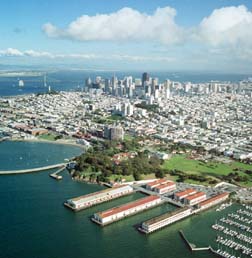
Ft. Mason: one small part of the Golden Gate National Recreation Area (GGNRA), the largest federal urban park system in the world. Photo courtesy Robert Campbell, Chamois Moon.
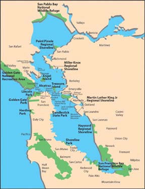
The Bay, ringed by recreational opportunities accessible by ferry. Illustration by Yvonne Chen/ABAG for WTA
